Search Results
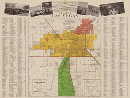
Map of the city of Las Vegas, North Las Vegas, the "Strip", 1957
Date
1957
Description
35 x 50 cm., folded to 22 x 10 cm. Panel title: Inside the greater Las Vegas area. Copyright held by Robert E. Barringer. Map is irregularly shaped. Map of California from San Francisco to Los Angeles to Las Vegas by Beth Bergh, index and advertisements on verso. Includes advertisements for Las Vegas businesses. Stamped on panel of Library's copy: Harrington Insurance Agency. Original publisher: Redwood Publishing Co..
Image
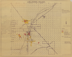
Map of Las Vegas Valley, 1968
Date
1968
Description
'This map compiled by General Drafting Service to show purchases in the Las Vegas area by Howard Hughes and others reported to be affiliated with him.' Shows land owned by Howard Hughes and land owned by Hughes Tool Company. Includes locations of casinos on Las Vegas Strip. Original publisher: General Drafting Service. Scale [ca. 1:48,000]. 1 in. to 4,000 feet. Hand-colored.
Image
#70389: Dawn Nielson, Boyd School of Law alum, became involved with endurance sports following surgery to remove a brain tumor. Photographed for the Law School Magazine on August 12, 2015., 2015 August 12
Level of Description
File
Archival Collection
University of Nevada, Las Vegas Creative Services Records (2010s)
To request this item in person:
Collection Number: PH-00388-05
Collection Name: University of Nevada, Las Vegas Creative Services Records (2010s)
Box/Folder: Digital File 00
Collection Name: University of Nevada, Las Vegas Creative Services Records (2010s)
Box/Folder: Digital File 00
Archival Component
Photograph used as source for an oil painting of Howard Cannon and Colonel Frank Krebs, original photograph taken on October 29, 1944 after they escaped following getting shot down in the Netherlands: photographic print, 1959
Level of Description
Item
Archival Collection
Howard Cannon Photograph Collection
To request this item in person:
Collection Number: PH-00192
Collection Name: Howard Cannon Photograph Collection
Box/Folder: Folder 05
Collection Name: Howard Cannon Photograph Collection
Box/Folder: Folder 05
Archival Component
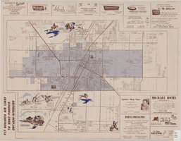
Map of the city of Las Vegas, 1953
Date
1953
Description
24 x 38 cm. on sheet 43 x 56 cm., folded to 28 x 13 cm. Includes advertisements for Las Vegas businesses. Advertisements for Las Vegas businesses, inset map of North Las Vegas, and index on verso. Copyright held by Redwood Pub. Co. Includes inset map of the Strip (U.S. 91 or Los Angeles Highway). Map is irregularly shaped. Original publisher: Redwood Pub. Co..
Image
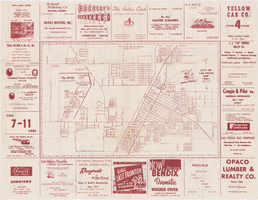
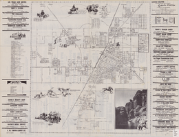
General map of Las Vegas, Nevada, circa 1957
Date
1955 to 1959
Description
'Compiled and issued by the Campbell Realty Company.' At top pf map: ' Greater Las Vegas.' Shows names of housing tracts and locations of hotels and motels on the Las Vegas Strip. Includes indexes and photographs of local recreation and attractions. Originally published by Campbell Realty
distributed by Las Vegas Nevada Chamber of Commerce . Scale (ca. 1:39,000. 1 in. to approx. 3,250 ft.].
distributed by Las Vegas Nevada Chamber of Commerce . Scale (ca. 1:39,000. 1 in. to approx. 3,250 ft.].
Text
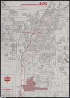
Map of metropolitan Las Vegas, Nevada, 1971
Date
1971
Description
At top of map: 'Avis Rent a Car System.' 'Copyright The H.M.Gousha Company... San Jose, Calif.' '8-SS-1044-S.' Scale [ca. 1:43,718]. 1 in. equals approx 0.69 miles. On verso: map of 'Las Vegas [and] Lake Mead Recreational Area, 1971 edition'; map of McCarran International Airport ('1274-S'); and list of Avis Rent A Car locations. H.M. Gousha Co.
Text
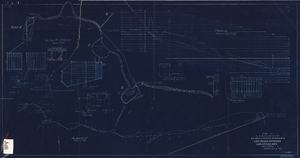
Blueprint showing proposed improvement of Las Vegas Springs, Las Vegas, Nevada, September 21, 1916
Date
1916-09-21
Archival Collection
Description
'Exhibit A'. 'Approved Sept. 21, 1916.' '2-N-1719' handwritten in lower right corner. 'W.E.J."--Lower left corner. "L-44 - 50 to 61. T-75 - 17 & 46"--Upper left corner. Includes discharge figures and plans for improvements to springs. Scale [ca. 1:240]. 1 in. to 20 feet. -- Scale [ca. 1:2,400]. 1 in. to 200 ft. Vertical scale [ca. 1:48]. 1 in. to 4 feet. -- Scale [ca. 1:4,800]. 1 in. to 100 feet. 1 map. Contents: Detail at springs -- Profile -- Alignment.
Image

Topographic map of Nevada-California, Las Vegas quadrangle, 1951
Date
1951
Description
'Edition of Mar. 1908, reprinted 1951.' 'E.M. Douglas, geographer in charge; Topography and triangulation by R.H. Chapman, B.D. Stewart, J.E. Blackburn, and D.F.C. Moor. Surveyed in 1906-1907.' Scale 1:250,000 ; polyconic proj. (W 116°00--W 115°00/N 37°00--N 36°00). Relief shown by contours and spot heights. Title in lower-right corner: Nev.-Calif., Las Vegas. Contour interval 100 feet. Datum is mean sea level. U.S. Geological Survey
Image
Street map of the city of Las Vegas, North Las Vegas, the "Strip", 1955
Date
1955
Description
41 x 38 cm., folded to 28 x 15 cm. Panel title: Welcome map, greater Las Vegas area. Includes inset map of Meikle Manor subdivision. Includes list of churches in Las Vegas, mileages from Las Vegas to other cities in the Southwest and notes. Helldorado ed. 1955. Map is irregularly shaped. Index and advertisements on verso. Original publisher: Adco Publishing Co..
Image