Search Results
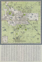
Map of Las Vegas and vicinity, 1963
Date
1963
Description
42 x 39 cm., folded to 21 x 9 cm. Panel title: Las Vegas and southern Nevada map and street guide. Includes index. Includes illustrations . Advertisement for Nevada State Bank, text with facts about Las Vegas and maps of Henderson, Boulder City and downtown Las Vegas on verso. "Courtesy of Nevada State Bank."--Panel. Original publisher: Thomas Bros. Maps.
Image

Street map of greater Las Vegas, Nevada, 1965-1966
Date
1965 to 1966
Description
Rev. 1965-1966 ed. 55 x 42 cm., folded to 29 x 12 cm. Panel title: Front Boy's official street map. Relief shown by spot heights. Copyright held by Russell A. Meador. Includes notes, quotations and indexes. Street index on verso. "Detailed guide of North Las Vegas, Las Vegas, Paradise Valley, and vicinity." Original publisher: Meador, Russell A.
Image

Street map of the Las Vegas area, circa 1960
Date
1959 to 1960
Description
53 x 65 cm., folded to 22 x 9 cm. Panel title: Welcome map & established guide to the greater Las Vegas area and scenic routes to and from there. Includes index and advertisements for local businesses. Las Vegas Motel Association map on verso along with advertisements, information on the Las Vegas Convention Center, and sightseeing information. Map was probably distributed by the Las Vegas Chamber of Commerce. Library's copy has freeway, service road, and streets connecting to the freeway marked with different colors of crayon and includes notes. 1960 ed. Map is irregularly shaped. Original publisher: Las Vegas Motel Association.
Image
Concert prep and follow up teacher's guide, 1972-1973
Level of Description
File
Archival Collection
Young Audiences New York, Nevada Humanities Collection
To request this item in person:
Collection Number: MS-00227
Collection Name: Young Audiences New York, Nevada Humanities Collection
Box/Folder: Box 05
Collection Name: Young Audiences New York, Nevada Humanities Collection
Box/Folder: Box 05
Archival Component
Hotel, Round Mountain, following a flood, 1931 August 12
Level of Description
File
Archival Collection
Nye County, Nevada Photograph Collection
To request this item in person:
Collection Number: PH-00221
Collection Name: Nye County, Nevada Photograph Collection
Box/Folder: Folder 39
Collection Name: Nye County, Nevada Photograph Collection
Box/Folder: Folder 39
Archival Component
Nevada trip: follow-up memorandum, background information, 1987
Level of Description
File
Archival Collection
Senator Chic Hecht Political Papers
To request this item in person:
Collection Number: MS-00003
Collection Name: Senator Chic Hecht Political Papers
Box/Folder: Box 036
Collection Name: Senator Chic Hecht Political Papers
Box/Folder: Box 036
Archival Component
Procedures to be followed by the cameramen and assistant cameramen, approximately 1930 to 1933
Level of Description
File
Archival Collection
Howard Hughes Film Production Records
To request this item in person:
Collection Number: MS-01036
Collection Name: Howard Hughes Film Production Records
Box/Folder: Box 477 (Restrictions apply)
Collection Name: Howard Hughes Film Production Records
Box/Folder: Box 477 (Restrictions apply)
Archival Component
Rise to Follow by Albert Spalding, 1944 July
Level of Description
File
Archival Collection
Beverly Rogers Collection of Armed Services Editions
To request this item in person:
Collection Number: MS-00913
Collection Name: Beverly Rogers Collection of Armed Services Editions
Box/Folder: Case ase_bookcase
Collection Name: Beverly Rogers Collection of Armed Services Editions
Box/Folder: Case ase_bookcase
Archival Component
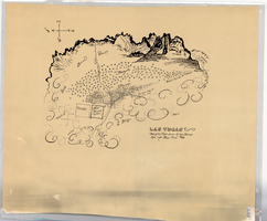
Hand-drawn map of Las Vegas, Nevada, circa 1855
Date
1850 to 1859
Description
Not drawn to scale. Relief shown pictorially. Facsimile of manuscript map. Oriented with north to left. Shows Las Vegas Mormon Fort, desert, mountains.
Image

Map of Las Vegas, Nevada, annotated to show different soil types, September 2, 1948
Date
1948-09-02
Archival Collection
Description
'Types of soil as determined by James M. Montgomery for use in appraisal. (Copy). LRM 7/10/52'--handwritten in blue pencil in lower right corner of map. 'September 2, 1947. Revised September 2, 1948.' Soil was designated as badly corrosive, mildly corrosive, or non-corrosive by hand-drawn colored lines and hand-printed labels. Soil was surveyed to measure its effect on water pipes. Scale [ca. 1:7,200] 1 in.=600 feet.
Image