Search Results
Las Vegas McCarran International Airport resumes flights after 'temporarily' suspending them following shooting | Fox News: archived website, 2017
Level of Description
Other Level
Archival Collection
Web Archive on the October 1, 2017 Shooting in Las Vegas, Nevada
To request this item in person:
Collection Number: MS-00866
Collection Name: Web Archive on the October 1, 2017 Shooting in Las Vegas, Nevada
Box/Folder: N/A
Collection Name: Web Archive on the October 1, 2017 Shooting in Las Vegas, Nevada
Box/Folder: N/A
Archival Component
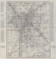
Street map of greater Las Vegas, 1963
Date
1963
Description
55 x 44 cm. Panel title: Front Boy's official 1963-1964 edition street map : detailed guide of North Las Vegas, Las Vegas, Paradise Valley and vicinity. Relief shown by spot heights. Originally folded to: 29 x 12 cm. "Note, revised and recorded 1st - 1961, 2nd - 1962, 3rd 1963, 4th - 1963."On verso: "MAR 1964" stamped in red ink on upper right hand corner. Includes notes and quotations. Includes indexes. Original publisher: Front.
Image

Topographic map of the Las Vegas Valley and surrounding northern and western mountain ranges, 1943
Date
1943
Description
'Edition of Mar. 1908, reprinted 1943.' 'E.M. Douglas, Geographer in charge. Topography and triangulation by R.H. Chapman, B.D. Stewart, J.E. Blackburn and D.F.C. Moor. Surveyed in 1906-1907.' Scale 1:250,000 ; polyconic proj. (W 116°00´--W 115°00´/N 37°00´--N 36°00´). Relief shown by contours and spot heights. 'Contour interval 100 feet.' 'Datum is mean sea level.' Includes township and range lines. Text and illustrations from the Topographic maps of the United States series on verso. Series: The topograhic maps of the United States. Map includes the Desert Range; Sheep Range; Pintwater Range; Las Vegas Range; Spring Mountains; Indian Springs Valley; Spotted Range. United States, Dept. of the Interior, Geological Survey
Text

Map of Las Vegas Valley, Clark County, Nevada, 1954
Date
1954
Description
Scale [ca. 1:63,360. 1 in. to approx. 5,280 ft.].Cadastral map. 'Compiled for C.D. Baker, Reg. Civil Engineer Nevada No. 6 and Licensed Real Estate Broker by Tyson Engineering Co., Las Vegas, Nevada.' 'Copyright 1954 Tyson Engineering Co., Las Vegas, Nevada. Drawn by E.M. Ballinger' Tyson Engineering Company
Image

Map of city of Las Vegas, Nevada, October 1, 1940
Date
1940-10-01
Description
'Compiled by C.D. Baker, Oct. 1, 1940.' Scale [ca. 1:11,400]. 1 in. to 950 ft. Cadastral map.
Image
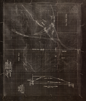
Topographic map showing proposed reservoir for the Las Vegas Rancho, August 4, 1931
Date
1931-08-04
Archival Collection
Description
'Chief Engineers Office, Los Angeles, Calif. August 4, 1931. Scale: 1"=100'. Drawn by L.P.D. 1"=10'.' Accompanies: Letter from R. L. Adamson to F. H. Knickerbocker, August 18, 1931 (Folder 6B: 18-1-9).
Image

Blueprint map showing proposed changes to water system, Las Vegas Land & Water Co., Las Vegas, Nevada, circa 1936
Date
1931 to 1941
Archival Collection
Description
'U.P.C. Co. #1799.31-T3-L3.'
Image

Map of Las Vegas and vicinity, Clark County, Nevada, November 1952
Date
1952-11
Description
'Copyright 1950. 3rd issue, November 1952.'
Image

Topographic map of groundwater in the southwest quadrangle of Las Vegas, Nevada, 1985
Date
1985
Description
'Las Vegas Area Map 3Bf.' 'Prepared in cooperation with the U.S. Geological Survey.' ' Water Resources Division, U.S. Geological Survey, Carson City, Nevada.' Scale 1:24,000 (W 115°15´00?--W 115°07´30? / N 36°07´30?--N 36°00´00?). Series: Las Vegas area map ; 3Bf. Urban area maps. Las Vegas area map ; 3Bf. Relief shown by contour lines and spot heights. Title in right and left margins: Las Vegas SW quad : ground water. Title on publications list on Nevada Bureau of Mines and Geology website: Groundwater map of the Las Vegas SW quadrangle. Series: Urban area maps [Las Vegas area map] from list of publications on Nevada Bureau of Mines and Geology website. Nevada Bureau of Mines and Geology
Text

Street map of the city of Las Vegas & vicinity, showing streets, main roads and recreation areas, 1954
Date
1954
Description
7 maps on 3 sheets, 2 leaves ; 21 x 31 cm. or smaller on sheets 22 x 35 cm. folded to 22 x 13 cm. in paper cover. Title from cover. Copyright held by James E. Stringer. 1st ed. Includes maps of North Las Vegas, the Strip and Vegas Heights and Meadow Acres. Includes key to map coordinates. Includes index. "Map of Las Vegas & Vicinity showing streets, main roads, and recreation areas." Original publisher: R.W. Baldwin.
Image