Search Results
Procedures to be followed by the cameramen and assistant cameramen, approximately 1930 to 1933
Level of Description
File
Archival Collection
Howard Hughes Film Production Records
To request this item in person:
Collection Number: MS-01036
Collection Name: Howard Hughes Film Production Records
Box/Folder: Box 477 (Restrictions apply)
Collection Name: Howard Hughes Film Production Records
Box/Folder: Box 477 (Restrictions apply)
Archival Component
Hotel, Round Mountain, following a flood, 1931 August 12
Level of Description
File
Archival Collection
Nye County, Nevada Photograph Collection
To request this item in person:
Collection Number: PH-00221
Collection Name: Nye County, Nevada Photograph Collection
Box/Folder: Folder 39
Collection Name: Nye County, Nevada Photograph Collection
Box/Folder: Folder 39
Archival Component
Rise to Follow by Albert Spalding, 1944 July
Level of Description
File
Archival Collection
Beverly Rogers Collection of Armed Services Editions
To request this item in person:
Collection Number: MS-00913
Collection Name: Beverly Rogers Collection of Armed Services Editions
Box/Folder: Case ase_bookcase
Collection Name: Beverly Rogers Collection of Armed Services Editions
Box/Folder: Case ase_bookcase
Archival Component

Blueprint map showing proposed changes to water system, Las Vegas Land & Water Co., Las Vegas, Nevada, circa 1936
Date
1931 to 1941
Archival Collection
Description
'U.P.C. Co. #1799.31-T3-L3.'
Image

Topographic map of groundwater in the southwest quadrangle of Las Vegas, Nevada, 1985
Date
1985
Description
'Las Vegas Area Map 3Bf.' 'Prepared in cooperation with the U.S. Geological Survey.' ' Water Resources Division, U.S. Geological Survey, Carson City, Nevada.' Scale 1:24,000 (W 115°15´00?--W 115°07´30? / N 36°07´30?--N 36°00´00?). Series: Las Vegas area map ; 3Bf. Urban area maps. Las Vegas area map ; 3Bf. Relief shown by contour lines and spot heights. Title in right and left margins: Las Vegas SW quad : ground water. Title on publications list on Nevada Bureau of Mines and Geology website: Groundwater map of the Las Vegas SW quadrangle. Series: Urban area maps [Las Vegas area map] from list of publications on Nevada Bureau of Mines and Geology website. Nevada Bureau of Mines and Geology
Text

Topographic map of the northeast quadrangle of the metropolitan Las Vegas, Nevada area, 1967
Date
1967
Description
Scale 1:24,000 ; polyconic proj. (W 115°730--W 115°0000/N 36°1500--N 36°730) ; 1 map : col. ; 58 x 47 cm ; 7.5 minute series (topographic) ; Relief shown by contours and spot heights ; Filing title: Las Vegas NE, Nev ; "AMS 2956 II NE--Series V896." ; Contour interval 20 feet ; "Topography by photogrammetric methods from aerial photographs taken 1965. Field checked 1967." ;Includes quadrangle location map ; Interior--Geological Survey
Image

Topographic map of the northwest quadrangle of the metropolitan Las Vegas, Nevada area, 1967
Date
1967
Description
Scale 1:24,000 ; polyconic proj. (W 115°1500--W 115°730/N 36°1500--N 36°730) ; 1 map : col. ; 58 x 47 cm ; 7.5 minute series (topographic) ; Relief shown by contours and spot heights ; Filing title: Las Vegas NW, Nev ; "AMS 2956 II NW--Series V896." ; Contour interval 10 feet ; "Topography by photogrammetric methods from aerial photographs taken 1965. Field checked 1967." ; Includes quadrangle location map ; Interior--Geological Survey
Image

Topographic map of the southeast quadrangle of the metropolitan Las Vegas, Nevada area, 1967
Date
1967
Description
Scale 1:24,000 ; polyconic proj. (W 115°0730--W 115°0000/N 36°0730--N 36°0000) ; 1 map : col. ; 58 x 47 cm ; 7.5 minute series (topographic) ; Relief shown by contours and spot heights ; Filing title: Las Vegas SE, Nev ; "AMS 2956 II SE--Series V896." ; Contour interval 20 feet ; "Topography by photogrammetric methods from aerial photographs taken 1965. Field checked 1967." ; Includes quadrangle location map ; Interior--Geological Survey
Image

Topographic map of the southwestern quadrangle of the metropolitan Las Vegas, Nevada area, 1967
Date
1967
Description
Scale 1:24,000 ; polyconic proj. (W 115°1500--W 115°0730/N 36°0730--N 36°0000) ; 1 map : col. ; 58 x 47 cm ; 7.5 minute series (topographic) ; Relief shown by contours and spot heights ; Filing title: Las Vegas SW, Nev ; "AMS 2956 II SW--Series V896." ; Contour interval 10 feet ; "Topography by photogrammetric methods from aerial photographs taken 1965. Field checked 1967." ; Includes quadrangle location map ; Interior--Geological Survey
Image
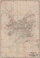
Street map of greater Las Vegas, Nevada, 1984
Date
1984
Description
'The professional street map of greater Las Vegas, Nevada. Detailed guide of Las Vegas, North Las Vegas, Paradise Valley & vicinity' -- front panel. ' Street index on map verso. Original publisher: Front Boy Service Co. Scale [ca. 1:44,352. 1 in. to approx. 0.70 mi.].
Text