Search Results
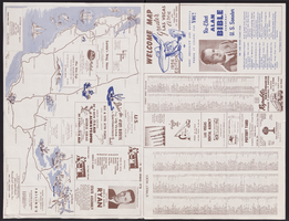
Map of Las Vegas, North Las Vegas, and The Strip, 1956
Date
1956
Description
1956 ed. 'Compiled by Redwood Publishing Co. Copyright 1956 by Robert E. Barringer ... Las Vegas, Nevada.' Panel title: Welcome map, greater Las Vegas area and scenic routes to and from there. Map of California from San Francisco to Los Angeles to Las Vegas drawn by Beth Bergh. Includes notes and street index. Includes advertisements for Las Vegas and California businesses. Scale [ca. 1:35,640. 1 in. to approx. 0.56 mile].
Text
Map of Las Vegas, North Las Vegas, and vicinity, June 1975
Date
1975-06
Description
'Cartographic Department. Copyright by California State Automobile Association. C6-75.' 'Issued by California State Automobile Association and Automobile Club of Southern California. 6-75' on front panel. Indexes on map verso. Scale [ca. 1:32,400. 1 in. to approx. 2700 ft.]. California State Automobile Association.
Text
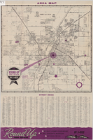
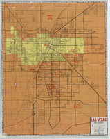
Street map of Las Vegas and North Las Vegas, circa 1963
Date
1961 to 1965
Description
36 x 37 cm. Panel title: Las Vegas area map. Includes index. Advertisements for Round-up Real Estate on verso. Original publisher: Round.
Image
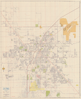
Street map of Las Vegas, North Las Vegas and vicinity, circa 1969
Date
1905-05-22
Description
Color; 100 x 58 cm., folded to 24 x 11 cm. "569." Indexes on verso. Library's copy has a small piece missing along the left-hand side of the map. Original publisher: California State Automobile Association.
Image
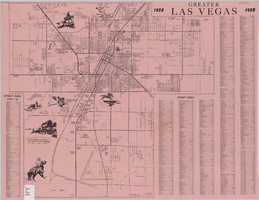
Greater Las Vegas, 1957
Date
1957
Description
42 x 44 cm., folded to 22 x 14 cm. Title in upper-right margin: Greater Las Vegas. Copyright held by Robert E. Barringer. Includes index. Map is irregularly shaped. Original publisher: Redwood Publishing Co..
Image
#71066: Opening of Shakespeare's First Folio reception with speakers followed by a sneak peak performance of sections of Nevada Conservatory Theatre's The Bomb-itty of Errors and then a viewing of the Folio, September 1, 2016, 2016 September 01
Level of Description
Item
Archival Collection
University of Nevada, Las Vegas Creative Services Records (2010s)
To request this item in person:
Collection Number: PH-00388-05
Collection Name: University of Nevada, Las Vegas Creative Services Records (2010s)
Box/Folder: Digital File 01
Collection Name: University of Nevada, Las Vegas Creative Services Records (2010s)
Box/Folder: Digital File 01
Archival Component
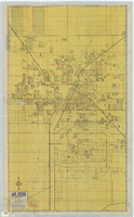
Street map of Las Vegas and vicinity, 1965
Date
1905-05-18
Description
1965 [ed.]. Color; 70 x 55 cm., folded to 24 x 10 cm. Panel title: Las Vegas, North Las Vegas and vicinity street map, home buyers guide. "1/65." Includes names of subdivisions. Index and advertisements for subdivisions on verso. "Compliments of First Western Savings & Loan Association."--Panel. "Drawn by Bob and Beverly Bennett, 1/65." Original publisher: Amusement Guide Publications of America.
Image
Picha, K. G., Jr., 1998c, "Follow Up Response to Repository EIS Data Call for High-Level Waste," interoffice memorandum to W. Dixon, U.S. Department of Energy, Office of Waste Management, Washington, D.C., 1998
Level of Description
File
Archival Collection
Environmental Radiation Protection Standards for Yucca Mountain, Nevada
To request this item in person:
Collection Number: MS-00603
Collection Name: Environmental Radiation Protection Standards for Yucca Mountain, Nevada
Box/Folder: Box 20
Collection Name: Environmental Radiation Protection Standards for Yucca Mountain, Nevada
Box/Folder: Box 20
Archival Component
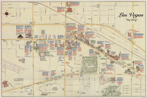
Maps of the Las Vegas Strip, downtown and metropolitan Las Vegas area, the Grand Canyon and southern Nevada, circa 1997
Date
1995 to 1999
Description
'Detail maps for downtown, neighborhoods, out of town, Grand Canyon' -- front panel. Maps on verso: Downtown -- Out of town and short adventures -- Greater Las Vegas -- Grand Canyon, South Rim Village. Major buildings and points of interest on the Las Vegas Strip shown pictorially. Includes text and notes. Originally published by MapEasy, Inc. Scale [ca. 1:10,560. 1 inch to approximately 1/6 mile].
Text
Promotional materials: "Follow Me to Las Vegas" magazine with the Carsony Brothers on the cover, "Chez Paree" photographs, "Lido" Paris Theater Magazines, "La Nouvelle Eve" Paris Magazine with an article on Margot Meyers, as well as programs and photographs of domestic and international performances, 1950-1980
Level of Description
File
Archival Collection
Karl Carsony Papers
To request this item in person:
Collection Number: MS-00807
Collection Name: Karl Carsony Papers
Box/Folder: Oversized Box 03
Collection Name: Karl Carsony Papers
Box/Folder: Oversized Box 03
Archival Component