Search Results

Map of Las Vegas, Nevada, annotated to show different soil types, September 2, 1948
Date
1948-09-02
Archival Collection
Description
'Types of soil as determined by James M. Montgomery for use in appraisal. (Copy). LRM 7/10/52'--handwritten in blue pencil in lower right corner of map. 'September 2, 1947. Revised September 2, 1948.' Soil was designated as badly corrosive, mildly corrosive, or non-corrosive by hand-drawn colored lines and hand-printed labels. Soil was surveyed to measure its effect on water pipes. Scale [ca. 1:7,200] 1 in.=600 feet.
Image
Photographs of Ole's Store 671 employees, including the following individuals: Louis Riggs, Chris Hunt, Bonnie Davis, Bernice Johnson, Miguel Torres, Marie Imus, Dana Schafer, Bill Lowe, Richard Diedrick, Colleen Schneider, Judy Kazel, and Rex Paulson, 1987-1988
Level of Description
Item
Archival Collection
Von Tobel Family Papers
To request this item in person:
Collection Number: MS-00589
Collection Name: Von Tobel Family Papers
Box/Folder: Box 04
Collection Name: Von Tobel Family Papers
Box/Folder: Box 04
Archival Component
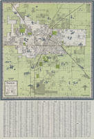
Map of Las Vegas and vicinity, 1963
Date
1963
Description
42 x 39 cm., folded to 21 x 9 cm. Panel title: Las Vegas and southern Nevada map and street guide. Includes index. Includes illustrations . Advertisement for Nevada State Bank, text with facts about Las Vegas and maps of Henderson, Boulder City and downtown Las Vegas on verso. "Courtesy of Nevada State Bank."--Panel. Original publisher: Thomas Bros. Maps.
Image

Map showing proposed annexation of Las Vegas Valley, Clark County, Nevada, January 1, 1929
Date
1929-01-01
Description
'Compiled by C. D. Baker, C.E., United States Mineral Surveyor, State Right Water Surveyor, Nevada. Las Vegas, Nev. January 1, 1929. Copyright applied for.' ; "Filed Dec. 10, 1936" and signed by Viola Burns, clerk, city of Las Vegas ; Hand-printed title at top of map: Proposed annexation to Las Vegas ; Map is stamped as Filed Dec 10, 1936 and signed by Las Vegas City Clerk Viola Burns. Library's copy has brown line hand-drawn around area to be annexed.
Image
T-Shirt Color: White; Front: Dolphins; Back: Where Traditions Begins Champions Follow; Handwritten Text: Numerous Names & Statements: United We Stand, Ashlee; I Love You, Rene; We Love NY, Mellissa; God Bless America, approximately 2001-2012
Level of Description
File
Archival Collection
New York-New York Hotel and Casino 9-11 Heroes Tribute Collection
To request this item in person:
Collection Number: MS-00459
Collection Name: New York-New York Hotel and Casino 9-11 Heroes Tribute Collection
Box/Folder: Box 378
Collection Name: New York-New York Hotel and Casino 9-11 Heroes Tribute Collection
Box/Folder: Box 378
Archival Component
#71160: The second Presidential Debate Watch Party held inside Greenspun Auditorium on October 9, 2016. Following the broadcast of the debate from St. Louis panelists Jacob Thompson, Michael Eisenstadt, Michael Green and David Fott took questions from the audience, 2016 October 09
Level of Description
Item
Archival Collection
University of Nevada, Las Vegas Creative Services Records (2010s)
To request this item in person:
Collection Number: PH-00388-05
Collection Name: University of Nevada, Las Vegas Creative Services Records (2010s)
Box/Folder: Digital File 01
Collection Name: University of Nevada, Las Vegas Creative Services Records (2010s)
Box/Folder: Digital File 01
Archival Component

Topographic map of the Las Vegas Valley and surrounding northern and western mountain ranges, 1943
Date
1943
Description
'Edition of Mar. 1908, reprinted 1943.' 'E.M. Douglas, Geographer in charge. Topography and triangulation by R.H. Chapman, B.D. Stewart, J.E. Blackburn and D.F.C. Moor. Surveyed in 1906-1907.' Scale 1:250,000 ; polyconic proj. (W 116°00´--W 115°00´/N 37°00´--N 36°00´). Relief shown by contours and spot heights. 'Contour interval 100 feet.' 'Datum is mean sea level.' Includes township and range lines. Text and illustrations from the Topographic maps of the United States series on verso. Series: The topograhic maps of the United States. Map includes the Desert Range; Sheep Range; Pintwater Range; Las Vegas Range; Spring Mountains; Indian Springs Valley; Spotted Range. United States, Dept. of the Interior, Geological Survey
Text

Official Arrow city map, Las Vegas & vicinity, Nevada, circa 1957-1961
Date
1957 to 1961
Description
71 x 68 cm. on sheet 106 x 71 cm., folded in cover 25 x 12 cm. Cover title: Latest edition, city map and street index of "fabulous" Las Vegas and vicinity, Nevada. Publisher from cover. "H-654-32." Includes indexes. Inside of cover includes information on Las Vegas. Includes inset maps of Boulder City, Nevada, and Las Vegas's location. Original publisher: R. L. Polk.
Image

Blueprint map showing proposed changes to water system, Las Vegas Land & Water Co., Las Vegas, Nevada, circa 1936
Date
1931 to 1941
Archival Collection
Description
'U.P.C. Co. #1799.31-T3-L3.'
Image

Topographic map of groundwater in the southwest quadrangle of Las Vegas, Nevada, 1985
Date
1985
Description
'Las Vegas Area Map 3Bf.' 'Prepared in cooperation with the U.S. Geological Survey.' ' Water Resources Division, U.S. Geological Survey, Carson City, Nevada.' Scale 1:24,000 (W 115°15´00?--W 115°07´30? / N 36°07´30?--N 36°00´00?). Series: Las Vegas area map ; 3Bf. Urban area maps. Las Vegas area map ; 3Bf. Relief shown by contour lines and spot heights. Title in right and left margins: Las Vegas SW quad : ground water. Title on publications list on Nevada Bureau of Mines and Geology website: Groundwater map of the Las Vegas SW quadrangle. Series: Urban area maps [Las Vegas area map] from list of publications on Nevada Bureau of Mines and Geology website. Nevada Bureau of Mines and Geology
Text