Search Results

Plat of H.F.M & M addition to city of Las Vegas, Clark County, Nevada, comprising the west 1/2 of N.W. 1/4 Sec. 27, Twp. 20 S., R. 61 E., M.D.B & M, March 8, 1924
Date
Description
Image
Status of Virgin River Chub and Other Fishes of the Muddy River Following 1995 Invasion of Blue Tilapia in Warm Springs Area, 2004
Level of Description
Archival Collection
Collection Name: Jeff Van Ee Papers
Box/Folder: Box 05
Archival Component
XF-11 plane's second flight immediately following take-off at the Hughes Airport in Culver City, California, 1947 April 04
Level of Description
Archival Collection
Collection Name: Howard Hughes Professional and Aeronautical Photographs
Box/Folder: Folder 07
Archival Component
Old Mormon and 49er road which followed the Spanish Trail. Looking west from Immigrant (sic) Pass, October 1967
Level of Description
Archival Collection
Collection Name: Sherwin "Scoop" Garside Papers
Box/Folder: Box 01
Archival Component
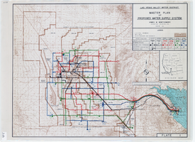
Topographic map of master plan for proposed water supply system for Las Vegas Valley Water District, August 1960
Date
Description
Image
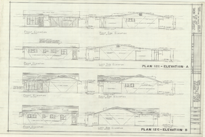
Architectural drawings of residential home in Las Vegas, Nevada, exterior elevations, 1955
Date
Archival Collection
Description
Two different sets of drawings of front, rear, left and right exterior elevations of a ranch-style residential home in the Greater Las Vegas development in Las Vegas, Nevada.
Site Name: Greater Las Vegas
Image
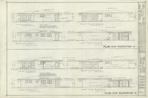
Architectural drawings of residential home in Las Vegas, Nevada, exterior elevations, 1955
Date
Archival Collection
Description
Two different sets of drawings of front, rear, left and right exterior elevations of a ranch-style residential home in the Greater Las Vegas development in Las Vegas, Nevada.
Site Name: Greater Las Vegas
Image
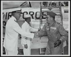
Rear Admiral F. J. Brush greets Howard Cannon immediately following his landing at Naval Station Mayport, Jacksonville, Florida: photographic print
Date
Archival Collection
Description
Image
Szymanski, Michael. Winner Takes All: a quer spin on the 1992 adult video news awards and the gay celebration that followed, Advocate, 1992 February 25
Level of Description
Archival Collection
Collection Name: UNLV Libraries Collection of Articles on Gaming and Las Vegas, Nevada Topics
Box/Folder: Box 17
Archival Component

General geologic map of Las Vegas, Pahrump, and Indian Spring Valleys, Clark and Nye Counties, Nevada, 1948
Date
Description
At top of map: 'United States Department of the Interior, Geological Survey. State Engineer of Nevada. Water resources bulletin No. 5, Plate 1.' Relief shown by spot heights. Includes 3 inset maps of wells and springs in the vicinity of Pahrump, Manse Ranch and Indian Springs, Nevada. Scale [ca. 1:126,720. 1 inch to approx. 2 miles] (W 116°--W 115°/N 40°--N 36°). Originally published as plate 1 in Geology and water resources of Las Vegas, Pahrump, and Indian Spring Valleys, Clark and Nye Counties, Nevada by George B. Maxey and C.H. Jameson (1948), which is number 5 of the Water resources bulletin published by the Nevada Office of the State Engineer.
Image