Search Results

Blueprint map showing proposed water pipeline from Big Spring to Las Vegas, Nevada, January 24, 1911
Date
Archival Collection
Description
Image
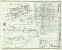
Architectural drawing of additions and alterations to the mens' and womens' health clubs in the Sands Hotel, Las Vegas, Nevada, April 19, 1965
Date
Description
Floor plans, sections, elevations for mens' and womens' health clubs at the Sands Hotel, Las Vegas, Nevada. Includes door and finish schedules. "Sheet no. 17A. Job no. 420. Drawn by Shoji Yasuda. Job captain, Mas Tokubo. 2-26-65. Revised 4-19-65."
Site Name: Sands Hotel
Address: 3355 Las Vegas Boulevard South;
Image

Plan of proposed new well pipe and fittings for Las Vegas, Nevada, 1936
Date
Archival Collection
Description
Image

Map showing profile of 24-inch cast iron water pipeline for Las Vegas, Nevada, May 20, 1930
Date
Archival Collection
Description
Image

Map showing plan for water quality management update for wastewater collection systems in the Las Vegas Valley, February 20, 1997
Date
Description
Image
Szymanski, Michael. Winner Takes All: a quer spin on the 1992 adult video news awards and the gay celebration that followed, Advocate, 1992 February 25
Level of Description
Archival Collection
Collection Name: UNLV Libraries Collection of Articles on Gaming and Las Vegas, Nevada Topics
Box/Folder: Box 17
Archival Component
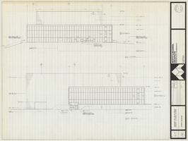
Architectural drawing of Performing Arts Center, Phase II, University of Nevada, Las Vegas, exterior elevations, July 31, 1974
Date
Archival Collection
Description
East and south exterior elevations of Performing Arts Center (later to become the Judy Bayley Theatre), University of Nevada, Las Vegas. Scale: 1/8" = 1'-0". "Drawn by J.A.L. Checked by O.D.S. Job no. 720. Date 7-31-74." "Sheet A-7 of 28."
Site Name: University of Nevada, Las Vegas
Address: 4505 S. Maryland Parkway
Image
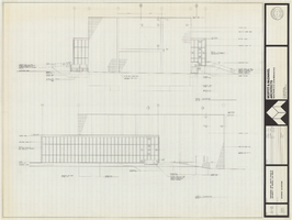
Architectural drawing of Performing Arts Center, Phase II, University of Nevada, Las Vegas, exterior elevations, July 31, 1974
Date
Archival Collection
Description
West and north exterior elevations of Performing Arts Center (later to become the Judy Bayley Theatre), University of Nevada, Las Vegas. Scale: 1/8" = 1'-0". "Sheet A-8 of 28." "Drawn by J.A.L. Checked by O.D.S. Job no. 720. Date 7-31-74."
Site Name: University of Nevada, Las Vegas
Address: 4505 S. Maryland Parkway
Image
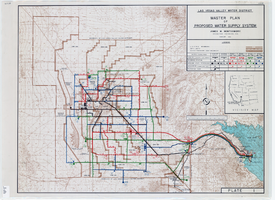
Topographic map of master plan for proposed water supply system for Las Vegas Valley Water District, August 1960
Date
Description
Image
Ada Belk (second from left) followed by Judy Bayley, U.S. Senator Howard Cannon, Mrs. Bonnie Gragson, and Gus Giuffre (at the podium), 1971
Level of Description
Archival Collection
Collection Name: Ann Valder Photograph Collection on Judy Bayley
Box/Folder: Folder 01
Archival Component