Search Results
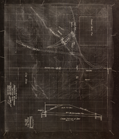
Topographic map showing proposed reservoir for the Las Vegas Rancho, August 4, 1931
Date
1931-08-04
Archival Collection
Description
'Chief Engineers Office, Los Angeles, Calif. August 4, 1931. Scale: 1"=100'. Drawn by L.P.D. 1"=10'.' Accompanies: Letter from R. L. Adamson to F. H. Knickerbocker, August 18, 1931 (Folder 6B: 18-1-9).
Image
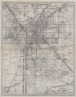
Map of greater Las Vegas, 1960
Date
1960
Description
55 x 44 cm., folded to 30 x 12 cm. Relief shown by spot heights. Includes notes and quotations. Includes indexes. Panel title: Front Boy's official 1962-1963 edition street map: detailed guide of North Las Vegas, Las Vegas, Paradise Valley and vicinity. 1962-1963 ed. Original publisher: Front Boy Service Co..
Image
Photographs of Ole's Store 671 employees, including the following individuals: Louis Riggs, Chris Hunt, Bonnie Davis, Bernice Johnson, Miguel Torres, Marie Imus, Dana Schafer, Bill Lowe, Richard Diedrick, Colleen Schneider, Judy Kazel, and Rex Paulson, 1987-1988
Level of Description
Item
Archival Collection
Von Tobel Family Papers
To request this item in person:
Collection Number: MS-00589
Collection Name: Von Tobel Family Papers
Box/Folder: Box 04
Collection Name: Von Tobel Family Papers
Box/Folder: Box 04
Archival Component
Paul Cummings dialog rehearsals [1968] (side A); Lavern Cummings [1966] sings "Almost in Your Arms;" "Wrap Your Troubles in Dreams;" "That Rainy Day is Here;" and "Love Me With All Your Heart;" followed by unintelligible recording of televised programs (side B), approximately 1966 to 1968
Level of Description
Item
Archival Collection
Paul Lavern Cummings Papers
To request this item in person:
Collection Number: MS-00971
Collection Name: Paul Lavern Cummings Papers
Box/Folder: Box 09
Collection Name: Paul Lavern Cummings Papers
Box/Folder: Box 09
Archival Component

Topographic map of the northeast quadrangle of the metropolitan Las Vegas, Nevada area, 1967
Date
1967
Description
Scale 1:24,000 ; polyconic proj. (W 115°730--W 115°0000/N 36°1500--N 36°730) ; 1 map : col. ; 58 x 47 cm ; 7.5 minute series (topographic) ; Relief shown by contours and spot heights ; Filing title: Las Vegas NE, Nev ; "AMS 2956 II NE--Series V896." ; Contour interval 20 feet ; "Topography by photogrammetric methods from aerial photographs taken 1965. Field checked 1967." ;Includes quadrangle location map ; Interior--Geological Survey
Image

Topographic map of the northwest quadrangle of the metropolitan Las Vegas, Nevada area, 1967
Date
1967
Description
Scale 1:24,000 ; polyconic proj. (W 115°1500--W 115°730/N 36°1500--N 36°730) ; 1 map : col. ; 58 x 47 cm ; 7.5 minute series (topographic) ; Relief shown by contours and spot heights ; Filing title: Las Vegas NW, Nev ; "AMS 2956 II NW--Series V896." ; Contour interval 10 feet ; "Topography by photogrammetric methods from aerial photographs taken 1965. Field checked 1967." ; Includes quadrangle location map ; Interior--Geological Survey
Image

Topographic map of the southeast quadrangle of the metropolitan Las Vegas, Nevada area, 1967
Date
1967
Description
Scale 1:24,000 ; polyconic proj. (W 115°0730--W 115°0000/N 36°0730--N 36°0000) ; 1 map : col. ; 58 x 47 cm ; 7.5 minute series (topographic) ; Relief shown by contours and spot heights ; Filing title: Las Vegas SE, Nev ; "AMS 2956 II SE--Series V896." ; Contour interval 20 feet ; "Topography by photogrammetric methods from aerial photographs taken 1965. Field checked 1967." ; Includes quadrangle location map ; Interior--Geological Survey
Image

Topographic map of the southwestern quadrangle of the metropolitan Las Vegas, Nevada area, 1967
Date
1967
Description
Scale 1:24,000 ; polyconic proj. (W 115°1500--W 115°0730/N 36°0730--N 36°0000) ; 1 map : col. ; 58 x 47 cm ; 7.5 minute series (topographic) ; Relief shown by contours and spot heights ; Filing title: Las Vegas SW, Nev ; "AMS 2956 II SW--Series V896." ; Contour interval 10 feet ; "Topography by photogrammetric methods from aerial photographs taken 1965. Field checked 1967." ; Includes quadrangle location map ; Interior--Geological Survey
Image

Map of Las Vegas Valley artesian basin, circa 1940
Date
1938 to 1942
Description
Scale [ca. 1:72,000. 1 in.=approx. 6,000 feet] (W 115°10´--W 115°/N 36°20´--N 36´). Shows wells, springs, boundary between valley fill and bedrock, and ground water district boundaries for Las Vegas Metropolitan Area and North Las Vegas. "Figure 1." Nevada. State Engineer
Image

Topographic map of the southwestern quadrangle of the metropolitan Las Vegas, Nevada area, 1973
Date
1973
Description
Scale 1:24,000 ; polyconic proj. (W 115°1500--W 115°0730/N 36°0730--N 36°0000) ; 1 map : col. ; 58 x 47 cm ; 7.5 minute series (topographic) ; Relief shown by contours and spot heights ; Filing title: Las Vegas SW, Nev ; "AMS 2956 II SW--Series V896." ; Contour interval 10 feet ; "Topography by photogrammetric methods from aerial photographs taken 1965. Field checked 1967." ; "Map photoinspected 1973. No major culture or drainage changes observed." ; Includes quadrangle location map ; Interior--Geological Survey
Image