Search Results
Street map of Las Vegas, 1966
Date
1966
Description
1966 ed. Color; 56 x 43 cm., folded to 23 x 10 cm. Panel title: Street map of Las Vegas and vicinity. On bottom of panel: Humble Oil & Refining Company. Index, photographs of Las Vegas scenes and nearby tourist attractions and map titled Lake Mead National Recreation Area, lower basin section on verso. Original publisher: H. M. Gousha Company.
Image
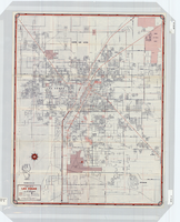
Street map of the city of Las Vegas, 1954
Date
1954
Description
22 x 34 cm. on sheet 36 x 54 cm. Copyright held by Redwood Publishing Co. Includes advertisements. 1954 [ed.] Street index, map of the Strip and advertisements on verso. Map is irregularly shaped. Original publisher: Redwood Pub. Co..
Image
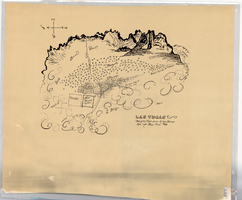
Hand-drawn map of Las Vegas, Nevada, circa 1855
Date
1850 to 1859
Description
Not drawn to scale. Relief shown pictorially. Facsimile of manuscript map. Oriented with north to left. Shows Las Vegas Mormon Fort, desert, mountains.
Image
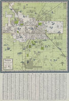
Map of Las Vegas and vicinity, 1963
Date
1963
Description
42 x 39 cm., folded to 21 x 9 cm. Panel title: Las Vegas and southern Nevada map and street guide. Includes index. Includes illustrations . Advertisement for Nevada State Bank, text with facts about Las Vegas and maps of Henderson, Boulder City and downtown Las Vegas on verso. "Courtesy of Nevada State Bank."--Panel. Original publisher: Thomas Bros. Maps.
Image

Map of Las Vegas, Nevada, annotated to show different soil types, September 2, 1948
Date
1948-09-02
Archival Collection
Description
'Types of soil as determined by James M. Montgomery for use in appraisal. (Copy). LRM 7/10/52'--handwritten in blue pencil in lower right corner of map. 'September 2, 1947. Revised September 2, 1948.' Soil was designated as badly corrosive, mildly corrosive, or non-corrosive by hand-drawn colored lines and hand-printed labels. Soil was surveyed to measure its effect on water pipes. Scale [ca. 1:7,200] 1 in.=600 feet.
Image

Map showing proposed annexation of Las Vegas Valley, Clark County, Nevada, January 1, 1929
Date
1929-01-01
Description
'Compiled by C. D. Baker, C.E., United States Mineral Surveyor, State Right Water Surveyor, Nevada. Las Vegas, Nev. January 1, 1929. Copyright applied for.' ; "Filed Dec. 10, 1936" and signed by Viola Burns, clerk, city of Las Vegas ; Hand-printed title at top of map: Proposed annexation to Las Vegas ; Map is stamped as Filed Dec 10, 1936 and signed by Las Vegas City Clerk Viola Burns. Library's copy has brown line hand-drawn around area to be annexed.
Image

Topographic map of the Las Vegas Valley and surrounding northern and western mountain ranges, 1943
Date
1943
Description
'Edition of Mar. 1908, reprinted 1943.' 'E.M. Douglas, Geographer in charge. Topography and triangulation by R.H. Chapman, B.D. Stewart, J.E. Blackburn and D.F.C. Moor. Surveyed in 1906-1907.' Scale 1:250,000 ; polyconic proj. (W 116°00´--W 115°00´/N 37°00´--N 36°00´). Relief shown by contours and spot heights. 'Contour interval 100 feet.' 'Datum is mean sea level.' Includes township and range lines. Text and illustrations from the Topographic maps of the United States series on verso. Series: The topograhic maps of the United States. Map includes the Desert Range; Sheep Range; Pintwater Range; Las Vegas Range; Spring Mountains; Indian Springs Valley; Spotted Range. United States, Dept. of the Interior, Geological Survey
Text
Concert prep and follow up teacher's guide, 1972-1973
Level of Description
File
Archival Collection
Young Audiences New York, Nevada Humanities Collection
To request this item in person:
Collection Number: MS-00227
Collection Name: Young Audiences New York, Nevada Humanities Collection
Box/Folder: Box 05
Collection Name: Young Audiences New York, Nevada Humanities Collection
Box/Folder: Box 05
Archival Component

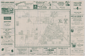
Official Arrow city map, Las Vegas & vicinity, Nevada, circa 1957-1961
Date
1957 to 1961
Description
71 x 68 cm. on sheet 106 x 71 cm., folded in cover 25 x 12 cm. Cover title: Latest edition, city map and street index of "fabulous" Las Vegas and vicinity, Nevada. Publisher from cover. "H-654-32." Includes indexes. Inside of cover includes information on Las Vegas. Includes inset maps of Boulder City, Nevada, and Las Vegas's location. Original publisher: R. L. Polk.
Image
Nevada trip: follow-up memorandum, background information, 1987
Level of Description
File
Archival Collection
Senator Chic Hecht Political Papers
To request this item in person:
Collection Number: MS-00003
Collection Name: Senator Chic Hecht Political Papers
Box/Folder: Box 036
Collection Name: Senator Chic Hecht Political Papers
Box/Folder: Box 036
Archival Component