Search Results

Map of city of Las Vegas, Nevada, October 1, 1940
Date
Description
Image
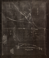
Topographic map showing proposed reservoir for the Las Vegas Rancho, August 4, 1931
Date
Archival Collection
Description
Image

Topographic map of the Las Vegas Valley area, 1959
Date
Description
Image
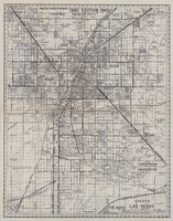
Map of greater Las Vegas, 1960
Date
Description
Image

Original plat, townsite of Las Vegas, Lincoln Co., Nevada, January 13, 1905
Date
Description
Subtitle: 'Embracing the N. 1/2 of S.W. 1/4 Sec. 27 Township 20S. R.61E. Mt. Diablo Meridian.' 'Book 1, page 17A" handwritten in lower right corner. Signed by Henry Lee, County Recorder, Lincoln County Nevada. 'Filed at request of J.T. Williams, January 13th A.D. 1905.' Backwards handwriting on right side. Map has a Lincoln County seal on the bottom near the center. In the dedication J.T. McWilliams states that he has surveyed and platted the townsite of Las Vegas subject to the right of way of the San Pedro, Los Angeles and Salt Lake Railroad Company. He signed the dedication on Jan. 13, 1905, and it was signed by witnesses Scale [ca. 1:2,520? 1 inch to approx. 210 feet?]. Copy of a blueline print.
Image

Newspaper headline: “Thyroid Disease, Cancer Follows Micronesia Fallout.”: photographic slide
Date
Archival Collection
Description
From the Sister Klaryta Antoszewska Photograph Collection (PH-00352). Written on the newspaper: "Honolulu Adv./S.B June 12, 1977".
Image
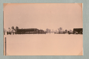
Ranch buildings following snowstorm at Walking Box Ranch, Nevada: photographic print
Date
Archival Collection
Description
Bell Family Scrapbook scanning, Set 4, proofed 11.04.2010 Snow at the Walking Box Ranch. Various ranch buildings in the background
Image

Map of Las Vegas and vicinity, Nevada, circa 1957-1961
Date
Description
Image
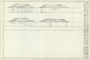
Architectural drawings of residential home in Las Vegas, Nevada, exterior elevations, 1955
Date
Archival Collection
Description
Drawings of exterior elevations of a ranch-style residential home in the Greater Las Vegas development in Las Vegas, Nevada. Handwritten underneath drawings at right: "Plan 14C - Elev. C."
Site Name: Greater Las Vegas
Image

Map of Las Vegas, Nevada, July 1947
Date
Description
Text