Search Results
Las Vegas SE quadrangle
Date
1973
Description
'Prepared by the U.S. Department of the Interior, Geological Survey, in cooperation with the U.S. Department of Housing and Urban Development, Federal Insurance Administration. 1973.'
Image

Las Vegas SW quadrangle
Date
1973
Description
'Prepared by the U.S. Department of the Interior, Geological Survey, in cooperation with the U.S. Department of Housing and Urban Development, Federal Insurance Administration. 1973.'
Image
"49: Telephone pole on Boulder Ranch Spur; 3354 at MP325, LZM48 3746 between Las Vegas Boulevard and sunset crossing with Landmark Hilton Sign and Stupak Tower with McCarren Airport; Caboose of LZM48 "I Follow the Leader" with Luxor, MGM , Landmark; 9050 "All you need is love," LZM48 West at Desk Hendon; Landmark and Hilton Sign Stupak Tower": photographs, 1994 March
Level of Description
File
Archival Collection
Ray Tutaj Jr. and Harv Kahn Photographs
To request this item in person:
Collection Number: PH-00456
Collection Name: Ray Tutaj Jr. and Harv Kahn Photographs
Box/Folder: Box 01
Collection Name: Ray Tutaj Jr. and Harv Kahn Photographs
Box/Folder: Box 01
Archival Component

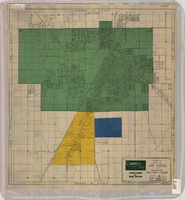
Map of the Las Vegas Strip, May 1950
Date
1950-05
Description
Scale [ca. 1:10,200. 1 in. to approx. 850 ft.] ; 1 map : col. ; 54 x 28 cm ; Cadastral map ; "May 1950." Campbell Realty.
Image
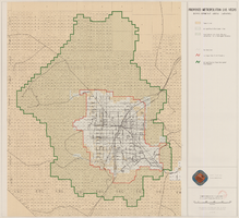
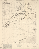
Map showing proposed metropolitan Las Vegas development area, June 24, 1997
Date
1997-06-24
Description
'Data sources: Advanced Planning Division, Clark County, Nevada.' 'Comprehensive Planning, Advanced Planning Division.' 'June 24, 1997.' Shows federal land, metropolitan Las Vegas development area, Las Vegas urban growth boundary and section lines. Scale [ca. 1:154,056. 1 inch to approx. 12,838 feet].
Image
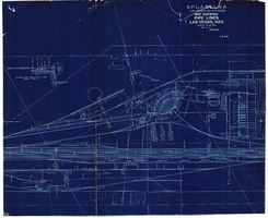
Map showing water pipelines, Las Vegas, Nevada, January 15, 1914
Date
1914-01-15
Archival Collection
Description
'S.P.L.A.&S.L.R.R., Los Angeles Division.' 'Jan. 15, 1914.' Includes other parts of water utilities besides pipelines such as sump pumps and water tanks. Scale varies. Blueprint. Library's copy includes hand-written notes.
Image
Map of Las Vegas and vicinity, Clark County, Nevada, April 15, 1951
Date
1951-04-15
Description
'2nd issue. 4/15/51.' 'Jack Asher, Reg. C.E. & Land Surveyor, Nev. #305.' Cadastral map..
Image
#68182: Artist and UNLV alumnus Troy Gillett installs a September 11th memorial sculpture inside Lied Library July 30, 2011 at the University of Nevada, Las Vegas The piece resembles a double-helix strand of DNA and will display 5,000 T-shirts that were collected at the New York, New York Hotel Casino following the 9/11 terrorism attack and donated to the Lied Libraries Special Collections., 2011 July 30
Level of Description
File
Archival Collection
University of Nevada, Las Vegas Creative Services Records (2010s)
To request this item in person:
Collection Number: PH-00388-05
Collection Name: University of Nevada, Las Vegas Creative Services Records (2010s)
Box/Folder: Digital File 00
Collection Name: University of Nevada, Las Vegas Creative Services Records (2010s)
Box/Folder: Digital File 00
Archival Component
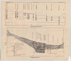
Cross-sections of wells and aquifers in the Las Vegas Valley, circa 1946
Date
1943 to 1949
Description
2 map sections on 1 sheet. Originally published as plate 6 in Geology and water resources of Las Vegas, Pahrump, and Indian Spring Valleys, Clark and Nye Counties, Nevada by George B. Maxey and C.H. Jameson, which is number 5 of the Water resources bulletin published by the Nevada Office of the State Engineer. Shows permeable and impermeable materials, wells, and aquifers.
Text