Search Results
A general map of Las Vegas, 1969
Date
1905-05-22
Description
Color; 60 x 55 cm. on sheet 64 x 96 cm. At top left of map: Map of greater Las Vegas. Includes index.
Image

Las Vegas Valley map, Clark County, Nevada, June 1958
Date
1958
Description
'Compiled 1954. First revision - June 1958.' 'Area extends 9 miles north, 11 miles south, and 3 miles east, 3 miles west city limits of Las Vegas.' Original publisher: Campbell Realty. Scale [ca. 1:60,000. 1 in. to approx. 5,000 ft.]. Cadastral map. Hand-drawn red line around some sections on map.
Image
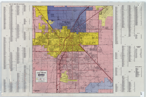
Map of Las Vegas Valley area, 1969
Date
1969
Description
'Featuring Las Vegas ... North Las Vegas ... Paradise Valley.' '1969 edition - revised' -- top of map. Original publisher: Front-Boy Service Co. 1969 ed. Scale [ca. 1:79,200]. 'Copyright - Russell A. Meador, 1968.' Front panel title: 'Front Boy's official 1969 edition street map.' Indexes on map verso. 'Walt Choik, editor, Front Boy Maps' -- back panel.
Text
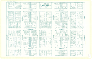
Map of downtown Las Vegas, Nevada, circa 1952-1955
Date
1952 to 1955
Description
Title in upper left and right margins: Las Vegas, Nevada. Identifies business tenants in the downtown area and includes property valuations, measurements, addresses, etc. Cadastral map. Oriented with north to the lower right.Text, illustrations, aerial photos, and ancillary map of the Las Vegas Strip on verso. Cataloger has determined date of map to be between 1952 and 1955 because the Sahara and the Sands Casinos are shown on the verso of the map, and they both opened in 1952, but the Riviera and the Dunes opened in 1955, and they are not shown on the map. Also, the Hotel Last Frontier is shown on the verso of the map, and its name was changed to New Frontier in 1955. Note: Many of the property names and addresses are erroneous when compared to Las Vegas business directories from the same period.
Image
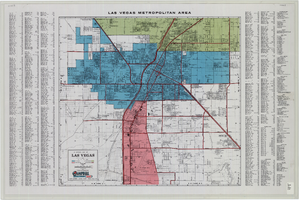
General map of Las Vegas, Nevada, June 1962
Date
1962-06
Description
At top of map: 'Las Vegas Metropolitan Area.' 'June 1962.' Includes indexes and information about Las Vegas. Published by Campbell Realty. Scale [ca. 1:31,680. 1 in. to approx. .5 miles].
Text
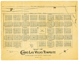
Map of Clark's Las Vegas Townsite, Lincoln County, Nevada, May 10, 1905
Date
1905-05-10
Archival Collection
Description
Scale: 1" = 100'. 1 map ; 28 x 22 cm. Verso of map is an announcement of the auction to be held May 15, 1905, for lots in the Las Vegas townsite. Pricing and lot information is included, as well as specials for railway tickets to Las Vegas from Los Angeles and Salt Like City. Las Vegas Land and Water Company
Text

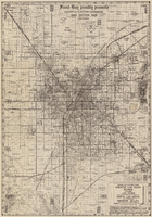
Map of metropolitan Las Vegas, Nevada area, circa 1957
Date
1955 to 1960
Description
Compiled and drawn by California State Automobile Association.--Panel ; "California State Automobile Association. Nevada Division." ; Includes indexes ; Includes inset maps of Nellis Air Force Base and area bounded on the north by Cheyenne Ave. and by Charleston Blvd. on the south. Signature of Elton M. Garrett of back of map. California State Automobile Association.
Text

City of Las Vegas map, 1952
Date
1952
Description
General information on Las Vegas and index on verso ; Copyright held by Redwood Publishing Co. ; Includes inset map of the Strip (U.S. 91 or Los Angeles Highway) ; Redwood Publishing Company
Text
Concert prep and follow up teacher's guide, 1972-1973
Level of Description
File
Archival Collection
Young Audiences New York, Nevada Humanities Collection
To request this item in person:
Collection Number: MS-00227
Collection Name: Young Audiences New York, Nevada Humanities Collection
Box/Folder: Box 05
Collection Name: Young Audiences New York, Nevada Humanities Collection
Box/Folder: Box 05
Archival Component
Nevada trip: follow-up memorandum, background information, 1987
Level of Description
File
Archival Collection
Senator Chic Hecht Political Papers
To request this item in person:
Collection Number: MS-00003
Collection Name: Senator Chic Hecht Political Papers
Box/Folder: Box 036
Collection Name: Senator Chic Hecht Political Papers
Box/Folder: Box 036
Archival Component