Search Results
Follow Your Heart, menu, approximately 1961 to 1990
Level of Description
Archival Collection
Collection Name: UNLV University Libraries Menu Collection
Box/Folder: Oversized Box 69
Archival Component
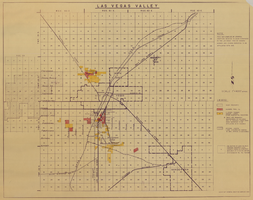
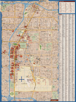
Map of Las Vegas Valley, 1968
Date
Description
Image
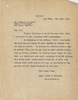
Letter from Walter R. Bracken (Las Vegas) to Leonard L. Arnett (Las Vegas), follow-up to letter with same date, June 20, 1935
Date
Archival Collection
Description
In his report of water production and consumption, Bracken forgot to report carload water sales to Boulder City.
Text
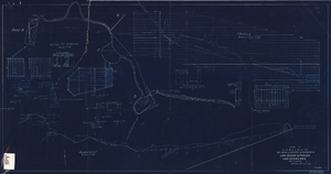
Blueprint showing proposed improvement of Las Vegas Springs, Las Vegas, Nevada, September 21, 1916
Date
Archival Collection
Description
'Exhibit A'. 'Approved Sept. 21, 1916.' '2-N-1719' handwritten in lower right corner. 'W.E.J."--Lower left corner. "L-44 - 50 to 61. T-75 - 17 & 46"--Upper left corner. Includes discharge figures and plans for improvements to springs. Scale [ca. 1:240]. 1 in. to 20 feet. -- Scale [ca. 1:2,400]. 1 in. to 200 ft. Vertical scale [ca. 1:48]. 1 in. to 4 feet. -- Scale [ca. 1:4,800]. 1 in. to 100 feet. 1 map. Contents: Detail at springs -- Profile -- Alignment.
Image

Topographic map of Nevada-California, Las Vegas quadrangle, 1951
Date
Description
Image
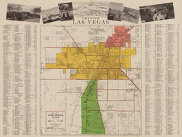
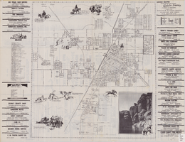
General map of Las Vegas, Nevada, circa 1957
Date
Description
Text

Map showing location of the Las Vegas & Tonopah Railroad from Las Vegas to Bullfrog, Nevada, 1906
Date
Archival Collection
Description
Image
Map of the city of Las Vegas, 1953
Date
Description
Image
Maps of Las Vegas metropolitan area, Grand Canyon National Park and national parks near Las Vegas, Nevada, 2008
Date
Description
Text
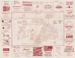
Street map of the city of Las Vegas, North Las Vegas, the "Strip", 1955
Date
Description
Image