Search Results

Official Arrow city map, Las Vegas & vicinity, Nevada, circa 1957-1961
Date
1957 to 1961
Description
71 x 68 cm. on sheet 106 x 71 cm., folded in cover 25 x 12 cm. Cover title: Latest edition, city map and street index of "fabulous" Las Vegas and vicinity, Nevada. Publisher from cover. "H-654-32." Includes indexes. Inside of cover includes information on Las Vegas. Includes inset maps of Boulder City, Nevada, and Las Vegas's location. Original publisher: R. L. Polk.
Image
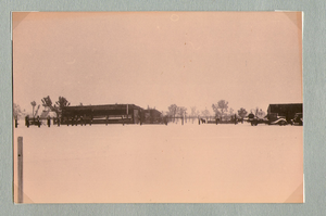
Ranch buildings following snowstorm at Walking Box Ranch, Nevada: photographic print
Date
1880 to 1979
Archival Collection
Description
Bell Family Scrapbook scanning, Set 4, proofed 11.04.2010 Snow at the Walking Box Ranch. Various ranch buildings in the background
Image
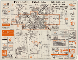
Las Vegas area map, 1960
Date
1960
Description
1960 ed. Scale [ca. 1:47,520. 1 in. equals approx. 0.75 miles.] 1 map : col. ; 41 x 43 cm., folded to 22 x 10 cm. Panel title: Welcome map : greater Las Vegas area and scenic routes to and from there. "1960-61 edition."--Panel. Irregularly-shaped map. Includes list of Las Vegas schools, inset maps of East Las Vegas (Whitney) and Wherry housing area on Nellis Air Force Base and advertisements for Las Vegas businesses. Index, mileages from cities in the United States to Las Vegas and sightseeing information on verso. Library's copy 1 has some art work and some lettering in orange and has "Las Vegas Nevada Chamber of Commerce" stamped in purple on panel. Library's copy 2 has some art work and some lettering in purple and has "Pioneer Title Insurance Co. of Nevada" stamped in black on panel. Nevada State Motel Association?
Text

Topographic map of the Las Vegas Valley and surrounding northern and western mountain ranges, 1943
Date
1943
Description
'Edition of Mar. 1908, reprinted 1943.' 'E.M. Douglas, Geographer in charge. Topography and triangulation by R.H. Chapman, B.D. Stewart, J.E. Blackburn and D.F.C. Moor. Surveyed in 1906-1907.' Scale 1:250,000 ; polyconic proj. (W 116°00´--W 115°00´/N 37°00´--N 36°00´). Relief shown by contours and spot heights. 'Contour interval 100 feet.' 'Datum is mean sea level.' Includes township and range lines. Text and illustrations from the Topographic maps of the United States series on verso. Series: The topograhic maps of the United States. Map includes the Desert Range; Sheep Range; Pintwater Range; Las Vegas Range; Spring Mountains; Indian Springs Valley; Spotted Range. United States, Dept. of the Interior, Geological Survey
Text

Map of Las Vegas Valley, Clark County, Nevada, 1954
Date
1954
Description
Scale [ca. 1:63,360. 1 in. to approx. 5,280 ft.].Cadastral map. 'Compiled for C.D. Baker, Reg. Civil Engineer Nevada No. 6 and Licensed Real Estate Broker by Tyson Engineering Co., Las Vegas, Nevada.' 'Copyright 1954 Tyson Engineering Co., Las Vegas, Nevada. Drawn by E.M. Ballinger' Tyson Engineering Company
Image
Donations made in name of Louis Wiener, Jr. following his death, 1996
Level of Description
File
Archival Collection
Valerie Wiener Papers
To request this item in person:
Collection Number: MS-01148
Collection Name: Valerie Wiener Papers
Box/Folder: Box 06
Collection Name: Valerie Wiener Papers
Box/Folder: Box 06
Archival Component
2017 Gaming Gender Equality Index corporation follow-up interviews, 2017
Level of Description
File
Archival Collection
Women of Diversity Productions, Inc. Records
To request this item in person:
Collection Number: MS-01161
Collection Name: Women of Diversity Productions, Inc. Records
Box/Folder: Box 09
Collection Name: Women of Diversity Productions, Inc. Records
Box/Folder: Box 09
Archival Component
"I Follow the Forest Flame Bird" manuscript draft, approximately 1980 to 2020
Level of Description
File
Archival Collection
Stephen G. Brown Literary Papers
To request this item in person:
Collection Number: MS-01090
Collection Name: Stephen G. Brown Literary Papers
Box/Folder: Box 12, Box 15
Collection Name: Stephen G. Brown Literary Papers
Box/Folder: Box 12, Box 15
Archival Component
Observed Damage at Groom Mine Following Shot of Plumbbob, July 9, 1964
Level of Description
Item
Archival Collection
Alice P. Broudy Papers on Broudy v. United States
To request this item in person:
Collection Number: MS-00097
Collection Name: Alice P. Broudy Papers on Broudy v. United States
Box/Folder: Box 24
Collection Name: Alice P. Broudy Papers on Broudy v. United States
Box/Folder: Box 24
Archival Component

Topographic map of groundwater in the southeast quadrangle of Las Vegas, Nevada, 1980
Date
1980
Description
'Las Vegas Area Map 3Af.' 'Prepared in cooperation with U.S. Geological Survey.' 'Water Resources Division, U.S. Geological Survey, Carson City, Nevada.' 'Topographic base from U.S. Geological Survey, Las Vegas SE 7 1/2 quadrangle, 1967.' Scale 1:24,000 (W 115°07'30"--W 115°00'00"/N 36°07'30"--N 36°00'00"). Series: Las vegas area map ; 3Af. Urban area maps. Las Vegas area map ; 3Af. Relief shown by contour lines and spot heights. Title in margins of map: Las Vegas SE quad. : ground water. Title on publications list on Nevada Bureau of Mines and Geology website: Groundwater map of the Las Vegas SE quadrangle. Series: Urban area maps [Las Vegas area map] from publications list on Nevada Bureau of Mines and Geology website. Nevada Bureau of Mines and Geology
Text