Search Results
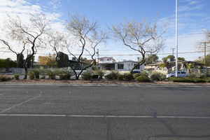
A median featuring desert landscaping on Civic Center Drive in residential neighborhoods, in North Las Vegas, Nevada: digital photograph
Date
Archival Collection
Description
From the UNLV University Libraries Photographs of the Development of the Las Vegas Valley, Nevada (PH-00394). Part of the collection documents the entire 19 mile length of the north/south Eastern Avenue / Civic Center Drive alignment. This photograph was captured in the section of Civic Center Drive between Cheyenne Avenue and Las Vegas Boulevard.
Image
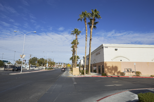
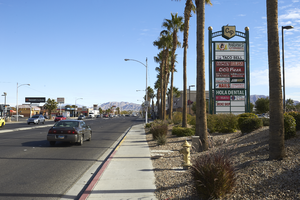
Commercial development on Civic Center Drive near Cheyenne Avenue, in North Las Vegas, Nevada: digital photograph
Date
Archival Collection
Description
From the UNLV University Libraries Photographs of the Development of the Las Vegas Valley, Nevada (PH-00394). Part of the collection documents the entire 19 mile length of the north/south Eastern Avenue / Civic Center Drive alignment. This photograph was captured in the section of Civic Center Drive between Cheyenne Avenue and Las Vegas Boulevard.
Image
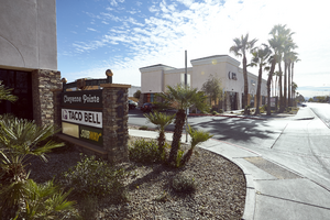
Marque for Cheyenne Pointe shopping center on Civic Center Drive near Cheyenne Avenue, in North Las Vegas, Nevada: digital photograph
Date
Archival Collection
Description
From the UNLV University Libraries Photographs of the Development of the Las Vegas Valley, Nevada (PH-00394). Part of the collection documents the entire 19 mile length of the north/south Eastern Avenue / Civic Center Drive alignment. This photograph was captured in the section of Civic Center Drive between Cheyenne Avenue and Las Vegas Boulevard.
Image
A Panda Express restaurant sits on the corner of Cheyenne Avenue and Civic Center Drive, in North Las Vegas, Nevada: digital photograph
Date
Archival Collection
Description
From the UNLV University Libraries Photographs of the Development of the Las Vegas Valley, Nevada (PH-00394). Part of the collection documents the entire 19 mile length of the north/south Eastern Avenue / Civic Center Drive alignment. This photograph was captured in the section of Civic Center Drive between Cheyenne Avenue and Las Vegas Boulevard.
Image
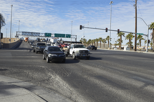
Cars travel on Cheyenne Avenue at Civic Center Drive, looking northwest in North Las Vegas, Nevada: digital photograph
Date
Archival Collection
Description
From the UNLV University Libraries Photographs of the Development of the Las Vegas Valley, Nevada (PH-00394). Part of the collection documents the entire 19 mile length of the north/south Eastern Avenue / Civic Center Drive alignment. This photograph was captured in the section of Civic Center Drive between Cheyenne Avenue and Las Vegas Boulevard.
Image
Marque for Cheyenne Pointe shopping center on Cheyenne Avenue, looking northeast in North Las Vegas, Nevada: digital photograph
Date
Archival Collection
Description
From the UNLV University Libraries Photographs of the Development of the Las Vegas Valley, Nevada (PH-00394). Part of the collection documents the entire 19 mile length of the north/south Eastern Avenue / Civic Center Drive alignment. This photograph was captured in the section of Civic Center Drive between Cheyenne Avenue and Las Vegas Boulevard.
Image
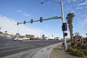
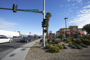
Civic Center Drive intersection with Cheyenne Avenue, looking northeast in North Las Vegas, Nevada: digital photograph
Date
Archival Collection
Description
From the UNLV University Libraries Photographs of the Development of the Las Vegas Valley, Nevada (PH-00394). Part of the collection documents the entire 19 mile length of the north/south Eastern Avenue / Civic Center Drive alignment. This photograph was captured in the section of Civic Center Drive between Cheyenne Avenue and Las Vegas Boulevard.
Image
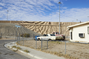
I-15 looms over a single family home on Hamilton Street, looking north in North Las Vegas, Nevada: digital photograph
Date
Archival Collection
Description
From the UNLV University Libraries Photographs of the Development of the Las Vegas Valley, Nevada (PH-00394). Part of the collection documents the entire 19 mile length of the north/south Eastern Avenue / Civic Center Drive alignment. This photograph was captured in the section of Civic Center Drive between Cheyenne Avenue and Las Vegas Boulevard.
Image
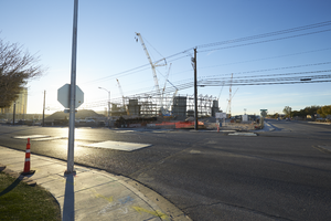
The intersection of West Hacienda and Polaris Avenues with Allegiant Stadium under construction, looking southeast in Las Vegas, Nevada: digital photograph
Date
Archival Collection
Description
Photographed as part of the UNLV Special Collections and Archives' Building Las Vegas collecting initiative started in 2016. This photo series documents ongoing construction work at the Allegiant Stadium.
Image
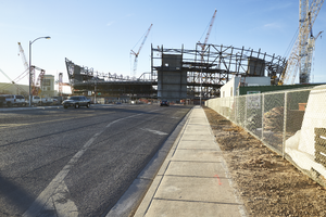
Al Davis Way leading up to the Allegiant Stadium construction site, looking south in Las Vegas, Nevada: digital photograph
Date
Archival Collection
Description
Photographed as part of the UNLV Special Collections and Archives' Building Las Vegas collecting initiative started in 2016. This photo series documents ongoing construction work at the Allegiant Stadium.
Image