Search Results
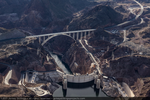
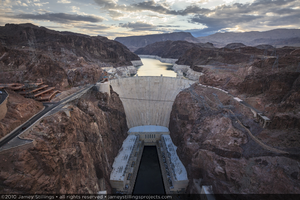
Photograph showing an aerial view of the Colorado River, Mike O'Callaghan-Pat Tillman Memorial Bridge, Hoover Dam, and Lake Mead, January 14, 2011
Date
2011-01-14
Archival Collection
Description
Photographer's notes: "Afternoon aerial view of the river, bridge, dam and Lake Mead, January 14, 2011. Note: The structural relationship between the bridge and the small bridge over the Arizona spillway can be easily seen." Site Name: Mike O'Callaghan-Pat Tillman Memorial Bridge
Image
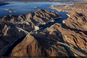
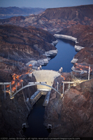
Photograph showing an aerial view of the Mike O'Callaghan-Pat Tillman Memorial Bridge, Hoover Dam, and Lake Mead, Nevada-Arizona border, January 14, 2011
Date
2011-01-14
Archival Collection
Description
Photographer's notes: "With the bridge complete and open, the bridge, dam and lake now share the Black Canyon." Site Name: Mike O'Callaghan-Pat Tillman Memorial Bridge
Image
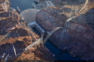
Photograph showing an aerial view of the Mike O'Callaghan-Pat Tillman Memorial Bridge, Hoover Dam, Colorado River, and Lake Mead, September 10, 2009
Date
2009-09-10
Archival Collection
Description
Photographer's notes: "Aerial view by early morning light shows the relationship between the respective arches of the dam and bridge, September 10, 2009." Site Name: Mike O'Callaghan-Pat Tillman Memorial Bridge
Image
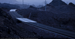
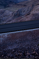
Photograph of the roadway approaching the Mike O'Callaghan-Pat Tillman Memorial Bridge near the Nevada side of Hoover Dam, April 29, 2009
Date
2009-04-29
Archival Collection
Description
Photographer's notes: "Roadway on Nevada side bridge approach, Hoover Dam Bypass, April 29, 2009."
Image
Photograph of the roadway approaching the Mike O'Callaghan-Pat Tillman Memorial Bridge near the Nevada side of Hoover Dam, April 29, 2009
Date
2009-04-29
Archival Collection
Description
Photographer's notes: "Roadway on Nevada side bridge approach, Hoover Dam Bypass, April 29, 2009."
Image
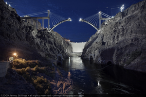
Photograph showing an upstream view of Hoover Dam and the Mike O'Callaghan-Pat Tillman Memorial Bridge under construction, Nevada-Arizona border, May 21, 2009
Date
2009-05-21
Archival Collection
Description
Photographer's notes: "Upstream view of the bridge and dam. The growing arch segments on the Nevada and Arizona sides of the canyon moved toward their rendezvous over the Colorado River." Site Name: Mike O'Callaghan-Pat Tillman Memorial Bridge
Image
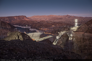
Photograph of the Mike O'Callaghan-Pat Tillman Memorial Bridge during construction, Hoover Dam, and Lake Mead at dusk, Nevada-Arizona border, October 21, 2009
Date
2009-10-21
Archival Collection
Description
Photographer's notes: "A view of the bridge, dam and Lake Mead at dusk. Pier and pier cap construction can be seen along the length of the arch." Site Name: Mike O'Callaghan-Pat Tillman Memorial Bridge
Image
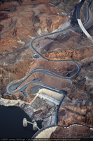
Photograph showing an aerial view of the original winding road descending to Hoover Dam with the new bypass road under construction in the upper right, Arizona border, February 3, 2010
Date
2010-02-03
Archival Collection
Description
Photographer's notes: "Aerial view of the winding original road descending to the dam on the Arizona side with the new bypass road under construction in the upper right, February 3, 2010." Site Name: Mike O'Callaghan-Pat Tillman Memorial Bridge
Image
Photograph of Hoover Dam and Lake Mead as seen from the Mike O'Callaghan-Pat Tillman Memorial Bridge pedestrian walkway, Nevada-Arizona border, July 29, 2010
Date
2010-07-29
Archival Collection
Description
Photographer's notes: "A view of Hoover Dam and Lake Mead from the bridge's pedestrian walkway. Before the bridge's construction, such a view would only have been possible in a helicopter. July 29, 2010." Site Name: Mike O'Callaghan-Pat Tillman Memorial Bridge
Image
Photograph of Lake Mead, Hoover Dam, and the Mike O'Callaghan-Pat Tillman Memorial Bridge under construction, Nevada-Arizona border, February 3, 2010
Date
2010-02-03
Archival Collection
Description
Photographer's notes: "Evening aerial view of the dam and bridge. Twelve tub (box) girders spanned the central pier caps of the bridge forming part of the substructure for the roadbed. Note: This photo was taken well after sunset and was only possible because of the state of digital technology in 2010." Site Name: Mike O'Callaghan-Pat Tillman Memorial Bridge
Image