Search Results
Public Improvements - Clark County - County Road, 1931
Level of Description
Archival Collection
Collection Name: Union Pacific Railroad Collection
Box/Folder: Box 69 (Restrictions apply)
Archival Component
Lease to Board of County Commissioners Lincoln County, 1914
Level of Description
Archival Collection
Collection Name: Union Pacific Railroad Collection
Box/Folder: Box 92 (Restrictions apply)
Archival Component

Map showing proposed annexation of Las Vegas Valley, Clark County, Nevada, January 1, 1929
Date
Description
Image
Clark County Planning Commission Research Library Collection
Identifier
Abstract
The Clark County Planning Commission Research Library Collection (1911-2004) consists of reports, publications, and proposals gathered by the Clark County Planning Commission that focus on the environmental impact of proposed developments, construction, or infrastructure improvements around the county. The collection contains materials related to various local, state, federal, and inter-agency workshops, committees, and agencies. Documents include activity reports, impact statements, annual budgets and reports, and detailed studies. The majority of the collection dates from 1970 to 1999.
Archival Collection
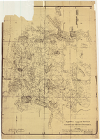
Map of approved mineral surveys in the Goldfield Mining District, Esmeralda and Nye Counties, Nevada, 1911
Date
Description
Image
Clark County 208 Water Quality Management Plan Records
Identifier
Abstract
The Clark County 208 Water Quality Management Plan Records contain reports produced by consultants and agencies for the Clark County Board of County Commissioners to create the Clark County, Nevada 208 Water Quality Management Plan (1960-1990). The collection also includes amendments and studies about the implementation of the plan.
Archival Collection