Search Results
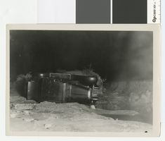
Photograph of cars overturned by a 4 mile cloudburst flood, circa 1931
Date
Archival Collection
Description
Car overturned by flood at 4-mile on the Boulder Highway, about 5 miles southeast of Las Vegas
Transcribed Notes: Handwritten collection note on back of photo: Cars overturned by cloudburst flood near wash by present-day Showboat. c. 1931-1932; Notes on photo sleeve: 'Photo taken at night with flash. Probably Chevrolet wrecked in flood in Vegas Wash. Water was 4 ft. deep on pavement.' (W.A. Davis, photographer)
Image

Photograph of leveling sand dunes west of the water tower in Boulder City, circa 1931
Date
Archival Collection
Description
Bulldozers leveling sand dunes west of the water tower in Boulder City.
Image
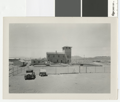
Photograph of water treatment plant in Boulder City, circa 1931
Date
Archival Collection
Description
Water purification plant in Boulder City.
Transcribed Notes: Notes on photo sleeve: Clarifiers in background, c. 1934 - built before anyone moved into B.C.
Image

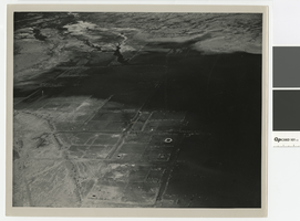
Aerial photograph of Alamo, Nevada, from an overlooking hill, circa 1922
Date
Archival Collection
Description
Alamo, Nevada from an overlooking hill
Transcribed Notes: Transcribed from back of photo: "About 1922 - Alamo - Looked like this."; Transcribed from photo sleeve: "An aerial of Alamo, Nevada ca. 1922"
Image
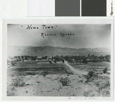
Aerial photograph of Alamo, Nevada, 1920-1925
Date
Archival Collection
Description
Alamo, Nevada from an overlooking hill
Transcribed Notes: Transcribed from front of photo: "Home Town. Alamo, Nevada. In 1920 to 1925."; Transcribed from photo sleeve: "An aerial of Alamo, Nevada looking west in the early 1920s. The four room schoolhouse where Logan Wright attended in 1954 is in the center-back of the picture. Alamo Services was owned and operated by Larry and Evy Davis."
Image
Aerial photograph of Saint Thomas, Nevada, being covered by Lake Mead, June 1938
Date
Archival Collection
Description
Aerial view of St. Thomas, Nevada, being covered by Lake Mead. Stamped on back of photo: Photograph by Bureau of Reclamation, Boulder Canyon Project, Boulder City, Nevada
Image
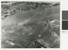
Aerial photograph of Downtown Henderson looking south towards Railroad Pass, circa 1963
Date
Archival Collection
Description
Aerial view of Henderson looking south towards Railroad Pass
Transcribed Notes: Transcribed from photo sleeve: "Aerial view of Downtown Henderson, NV"
Image
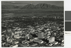
Aerial photograph of downtown Las Vegas looking east toward Frenchman Mountain, post-1953
Date
Archival Collection
Description
Aerial view of downtown Las Vegas looking east toward Frenchman Mountains. The following buildings are visible in the photograph: Lucky Casino, Horseshoe Casino, Fremont Hotel and Casino, Four Queens Casino, Golden Nugget, El Cortez Hotel, First National Bank, Bank of Nevada.
Transcribed Notes: Transcribed from photo sleeve: "Aerial view of Downtown Las Vegas"
Image
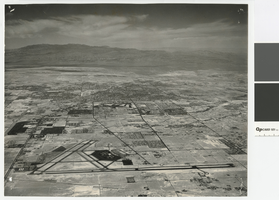
Aerial photograph of Las Vegas looking north, circa 1974
Date
Archival Collection
Description
Aerial view of Las Vegas looking north. The Strip, Paradise Road, and UNLV are visible in the photograph.
Transcribed Notes: Transcribed from photo sleeve: "Aerial view landing strip, Las Vegas Airport, 3-16-70"
Image

Photograph of Union Pacific Railroad crews removing tracks at the St. Thomas line, 1938
Date
Archival Collection
Description
Union Pacific Railroad crews taking up the St. Thomas line in advance of Lake Mead.
Transcribed Notes: Transcribed from photo sleeve: "Taking up track, advancing waters of Lake Mead in background"
Image