Search Results

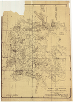
Map showing proposed annexation of Las Vegas Valley, Clark County, Nevada, January 1, 1929
Date
1929-01-01
Description
'Compiled by C. D. Baker, C.E., United States Mineral Surveyor, State Right Water Surveyor, Nevada. Las Vegas, Nev. January 1, 1929. Copyright applied for.' ; "Filed Dec. 10, 1936" and signed by Viola Burns, clerk, city of Las Vegas ; Hand-printed title at top of map: Proposed annexation to Las Vegas ; Map is stamped as Filed Dec 10, 1936 and signed by Las Vegas City Clerk Viola Burns. Library's copy has brown line hand-drawn around area to be annexed.
Image
Map of approved mineral surveys in the Goldfield Mining District, Esmeralda and Nye Counties, Nevada, 1911
Date
1911
Description
'Compiled from records of the U.S. Surveyor General and other authentic sources by Davis and Byler, Mining Engineers, Goldfield, Nevada. Copyright 1908 by Davis and Byler. 1911.' Scale [ca. 1:9,600]. 1 in. to 800 feet. (W 117°14'--W 117°09'/N 37°46'--N 37°41'). Blueline print. Includes township and range grid. Library's copy has upper-left corner torn off and has circles drawn around and diagonal lines drawn on certain claims.
Image
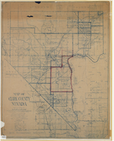
Map of Clark County, Nevada, 1927
Date
1927
Description
'Compiled by J.T. McWilliams from official county records, U.S. Land Dept. surveys, railroad co. field maps and many personal surveys. Made in 1927 by J.T. McWilliams, C.E.' Includes township and road districts, school districts, mining districts, railroads, wagon roads, trails, springs and artesian wells. Scale [ca. 1:316,800. 1 in. to approx. 5 miles] (W 116°--W 114°/N37--N35). Relief shown by hachures. Blueline print. Library's copy 1 has one area outlined by hand in red. Library's copy 2 has school districts outlined in red and green pencil and labeled in pencil by hand.
Image
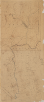
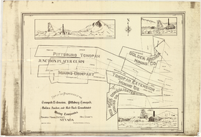
Map of properties in the Tonopah Mining District, Nye County, Nevada, circa 1901
Date
1897 to 1905
Description
'Surveyed by S.K. Bradford, U.S. Deputy.' 'May Bradford, Draughtsman.' Includes locations of mines and their main shafts and drawings of the hoists of the Tonopah Extension, Golden Anchor and the Red Rock Consolidated. Scale [ca. 1:2,400] 1 in. to 200 feet.
Image
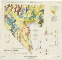
Geologic map of Clark County, Nevada, 1964
Date
1964
Description
'By C.R. Longwell, E.H. Pampeyan, and Ben Bowyer.' 'Prepared cooperatively by the U.S. Geological Survey.' 'Topographic base from Army Map Service Kingman (1947) and Las Vegas (1953) two-degree quadrangle. More recent editions were published after geological compilation and are used on Plate 2.' 'Geology compiled 1955 with revisions and additons to 1964.' At top of map: 'Nevada Bureau of Mines. Bulletin 62, Plate 1.' Published by Williams & Heintz Map Corp. Scale 1:250,000. Bulletin (Nevada Bureau of Mines)62. Relief shown by contours and spot heights. Includes two index maps and eight cross-sections.
Image
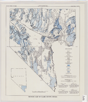
Tectonic map of Clark County, Nevada, 1965
Date
1965
Description
'Nevada Bureau of Mines. Bulletin 62, plate 5.' 'Prepared cooperatively by the U.S. Geological Survey.' Shows types of rocks as well as faults. Scale [ca. 1:760,320. 1 in. to approx. 12 miles] (W 116°--W 114°/N 37°--N 35°). Bulletin (Nevada Bureau of Mines)62.
Image

Plat of H.F.M & M addition to city of Las Vegas, Clark County, Nevada, comprising the west 1/2 of N.W. 1/4 Sec. 27, Twp. 20 S., R. 61 E., M.D.B & M, March 8, 1924
Date
1924-03-08
Description
Blue-line print ; 74 x 36 cm on sheet 79 x 61 cm. Survey was competed on March 8, 1924. Signed by the owners of the piece of property for the addition Roy W. Martin, Forest R. Mildren, William E. Ferron, and A. W. Ham, signed by the surveyor J.T. McWilliams, and notarized on March 31, 1924. Approved by the Board of City Commissioners and signed by the major W. C. German and by Florence S. Doherty, city clerk, on April 1, 1924. Recorded in Book 1 of plats, page 47. Includes township and range grid.
Image

Map showing general geology and areas of artesian flow of the Las Vegas, Pahrump, and Indian Spring Valleys, Clark and Nye Counties, Nevada, 1946
Date
1947
Description
'United States Department of Interior, Geological Survey, Water Resources Bulletin No. 6.' 'State Engineer of Nevada.' Relief shown by contours. Includes township and range lines. Scale [ca. 1:126,720. 1 in.=approx. 2 miles]. Series: Water resources bulletin (Carson City, Nev.)no. 6. Originally published as plate 1 in Ground water in Las Vegas, Pahrump, and Indian Spring Valleys, Nevada : a summary / G. B. Maxey and T. W. Robinson, prepared in cooperation with the United States Department of the Interior, Geological Survey, and published as no. 6 of the Water resources bulletin.
Image