
Search the Special Collections and Archives Portal

Search Results

Display    Results Per Page
Displaying results 21 - 30 of 194

Map of Argentite Red Mountain Mining District, Esmeralda County, Nevada, circa 1908-1913

Date

1908 to 1913

Description

'Compiled by C. A. Liddell, U.S. Mineral Surveyor, Tonopah, Nevada, from surveys by Sherwin, Giles and Liddell.' Published between 1908-1913? Scale [ca. 1:7,200]. 1 in. equals 600 feet. Map printed on linen.

Image

Surficial geologic map of the Specter Range NW quadrangle, Nye County, Nevada, 1989

Date

1989

Description

58 x 47 cm., on sheet 74 x 81 cm., folded in envelope 30 x 24 cm. Relief shown by contours and spot heights. "Geology mapped in 1984-85." Includes text, bibliography, and location maps. "Prepared in cooperation with the U. S. Deparment of Energy." "Base from U. S. Geological Survey, 1961. Photorevised 1983. 10,0000-foot grid ticks based on Nevada coordinate system, central zone. 1000-meter Universal Transverse Mercator grid ticks, zone 11, shown in blue." Original publisher: U. S. Geological Survey, Series: Miscellaneous investigations series map I, Scale: 1:24 000.

Image

Map of the Livingston Ranches near Overton, Clark County, Nevada, March 27, 1920

Date

1920-03-27

Description

Cadastral map. "Las Vegas Plat Book 1, page 42 --Lower left hand corner. "Survey completed March 27th, 1920, J. T. McWilliams, O. E." "Inset plat showing fractional areas adjacent to section corner sections = 12-13 Tp16S.R.67E, 7-18 Tp16S.R68E." Signed by the surveyor on March 28, 1920, and notarized. Includes an inset plat showing fractional area adjacent to section corner, sections 12-13 Tp. 16 S. R. 76 E., 7-18 Tp. 16 S. R. 6 8 E. Includes table of areas of tracts and table of reference ties to scribe marked objects. Recorded in Book 1, page 42 in the County Recorder of Deed's office. Includes township and range grid. Original publisher: Clark County, State of Nevada : D.H. Livingston, 1920, Scale: 600, blue, 82 x 68 cm.

Image

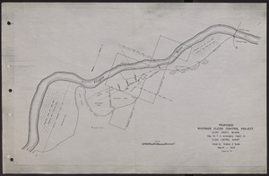
Map of proposed flood control project on the Virgin River in Clark County, Nevada, March, 1934

Date

1934-03

Description

'Map no. 7 to accompany report on flood control survey. Made by Graham S. Quate. March 1934. Drawn by T.K.' Scale [ca. 1:15, 600. 1 in.=approx. 1,300 feet]. Relief shown by hachures. North oriented to upper right corner. Library's copy has hand-drawn map and notes in pencil on verso.

Image

Plat showing original townsite and subdivisions, Las Vegas, Lincoln County, Nevada, May 1905

Date

1905-05

Description

Land owned by the San Pedro, Los Angeles & Salt Lake Railroad is outlined. Scale: [ca. 1:12,000]. 1 inch = 1,000 feet. Cadastral map. Blueline print. Additional copy available in the J.T. McWilliams manuscript collection

Image

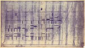
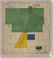
Plat of original townsite of Las Vegas, Clark County, Nevada, November 25, 1927

Date

1927-11-25

Description

Subtitle: 'On N 1/2 of SW 1/4 section 27, T 20 S, R 61 E, M.D. Mer. showing cast iron water mains. Including location and distances of valves, fire hydrants, house connections, etc. Constructed by Las Vegas Land &Water Company. Construction completed Nov. 25-1927. Cast iron pipe system throughout made at Provo, Utah by Pacific States Cast Iron Pipe Company. R.N. Clark, Construction Engineer. Map and survey made by J.T. McWilliams, C.E., Las Vegas, Nev.' Map shows ownership of some parcels of land. Scale [ca. 1:960]. 1 inch to 80 feet. Blueline print. Plat map.

Image

Geologic map of the Plutonium Valley quadrangle, Nye and Lincoln counties, Nevada, 1965

Date

1965

Description

58 x 46 cm., on sheet 77 x 83 cm., folded in envelope 30 x 24 cm. Relief shown by contours and spot heights. "Geology mapped in 1961." Includes description of map units, col. cross section, and quadrangle location map. "Prepared in cooperation with the U. S. Atomic Commission." Original publisher: Interior, Geological Survey, Series: Geologic quadrangle map GQ, Scale: 1:24 000.

Image

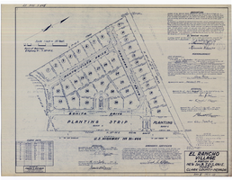
Plat map of El Rancho Village, Clark County, Nevada, July 28, 1942

Date

1942-07-28

Description

Map of housing subdivision outside the Las Vegas city limits. 'Approved this 28 day of July1942, by the City Planning Commission of the City of Las Vegas, County of Clark, Nevada. Approved this 28 day of July 1942, by the County Planning Commission of the County of Clark, State of Nevada.' Blueline print. Oriented with north to the upper right. Embossed with Engineering Certificate seal of Frank D. Rathburn, which states. 'Survey completed August 4, 1942.' 'Book II, page 53' hand printed in lower right corner. Signed by Clark County, Nevada Notary Public and other coumty officials and officials of El Rancho Village. Published by Office of F.D. Rathbun. Scale [ca. 1:600]. 1 inch to 50 feet

Text

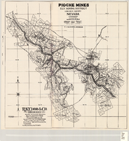
Map of Pioche mines, Ely Mining District, Lincoln County, Nevada, 1909

Date

1909

Description

'A.D. Knowlton, Mining Engineer, Pioche, Nevada; H.H. Snelgrove, Draftsman, Salt Lake City, Utah. Copyright 1909 Rufus K. Cobb.' Includes township and range grid; Includes wagon roads. Published by R.K. Cobb. Photocopy.

Image

Map of Las Vegas and vicinity, Clark County, Nevada, April 15, 1951

Date

1951-04-15

Description

'2nd issue. 4/15/51.' 'Jack Asher, Reg. C.E. & Land Surveyor, Nev. #305.' Cadastral map..

Image