Search Results
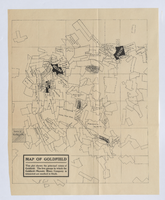
Map of Goldfield, circa 1904-1908
Date
1900 to 1912
Description
'This plat shows the principal mines of Goldfield. The five groups in which the Goldfield-Majestic Mines Company is interested are marked in black.'
Image
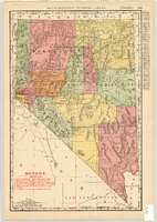
Map showing railroads in Nevada, 1904
Date
1904
Description
Relief shown by hachures. Added title: Rand McNally's new business map of Nevada. Shows range and township grid. Shows railroads. Color used to show boundaries of counties. Includes index to cities. On verso: Indexes to counties, lakes, mountains, rivers, towns, etc. Published by Rand McNally & Co. Scale [ca. 1:1,710,720]. 1 in. equals 27 miles (W 120°--W 114°/N 42°--N 35°). Originally published as pages 263 and 264 of Rand-McNally indexed atlas.
Text


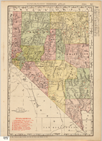
Map showing railroads in Nevada, 1911
Date
1911
Description
Relief shown by hachures. Title below scale: Rand McNally & Co.'s New business atlas map of Nevada. Shows railroads. Includes township and range grid. Includes index to principal cities with population statistics. Includes township and range grid. Index to Nevada counties, lakes, mountains, rivers, towns, etc. on verso. Published by Rand McNally & Co. Scale [ca. 1,710,720]. 1 in. = 27 miles (W 120°--W 114°/N 42°--N 35°). Published as page 321 of Rand-McNally indexed atlas.
Text
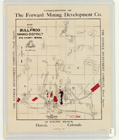
Map of the Bullfrog Mining District, Nye County, Nevada, circa 1905
Date
1901 to 1909
Description
At top of map: 'Compliments of the Forward Mining Development Co.' On left and right margins: 'The Patrick Investment Company, Fiscal Agents.' At bottom of map: '19 Toltec Block, Denver, Colorado.' 'The Williamson-Haffner Co., Denver.' Relief shown by hachures. Properties owned by Patrick Investment Company are marked in red. Shows railroads, roads, and pipelines. Scale [ca. 1:39,000. 1 in. to approx. 3,250 feet].
Image
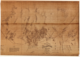
Map of the Bullfrog Mining District, Nye County, Nevada, circa 1905
Date
1901 to 1909
Description
'Compiled by Geo. E. Sherer and W.B. Milliken, miners and surveyors, Bull Frog, Nye Co., Nevada.' 'Photo. Lith. Britton & Rey, S.F.' Scale [ca. 1:16,800. 1 inch to approximately 1,400 feet]. Blueline print.
Image
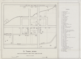
Map of St. Thomas, Nevada, circa 1933
Date
1930 to 1933
Archival Collection
Description
Hand-drawn map of St. Thomas, Nevada (ca. 1914-1932) which was abandoned in 1933 due to the construction of Hoover Dam and is now covered by Lake Mead, as remembered by Merle Frehner (a former resident of St.Thomas). Buildings and residences on map are numbered and explained in a key. "Mormon plat assumed." Scale: 1 1/2 in. = 300 ft.
Image