Search Results
Map of the eighth level of the Clermont Mine, Goldfield, Nevada, circa 1902-1908
Date
1902 to 1908
Description
Hand-drawn, hand-colored and annotated map showing the eighth level of the Clermont Mine.
Image
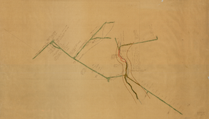
Map of the third level of the Clermont Mine, Goldfield, Nevada, circa 1902-1908
Date
1902 to 1908
Description
Hand-drawn, hand-colored and annotated map showing the third level of the Clermont Mine. 'Clermont, 3rd level, el. 5361.3.'
Image
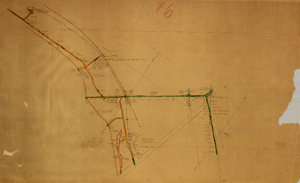
Map of the fourth level of the Clermont Mine, Goldfield, Nevada, circa 1902-1908
Date
1902 to 1908
Description
Hand-drawn, hand-colored and annotated map showing the fourth level of the Clermont Mine. Upper left and lower right corners missing.
Image
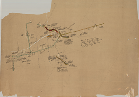
Map of the sixth level of the Clermont Mine, Goldfield, Nevada, circa 1902-1908
Date
1902 to 1908
Description
Hand-drawn, hand-colored and annotated map showing the sixth level of the Claremont Mine. 'Clermont, 6th level, el. 4971.4.'
Image
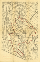
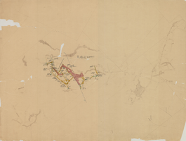
Map of mines owned and operated by Goldfield Deep Mines Company of Nevada, circa 1904-1908
Date
1904 to 1908
Description
Printed on map: 'Boundary in red.'
Image

Cross-section maps of Combination and Florence Mines, Goldfield, Nevada, circa 1902-1908
Date
1902 to 1908
Description
Maps of Combination and Florence Mines, Goldfield, Nevada.
Image
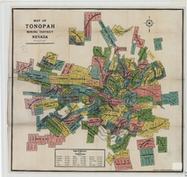
Map of Tonopah Mining District, Nevada, 1905
Date
1905
Description
In lower right corner: 'Copyrighed by Bradford & Bradford 1905.' Includes table of distances from Tonopah. Relief shown by hachures. Scale [ca. 1:15,600. 1 in. to approx. 1300 feet]. Library's copy has one section outlined in red pencil and 'Tonopah Victor' hand-printed on it in red pencil. Red pencil dots are on two other sections. '1905' and some illegible words written in pencil near title of map.
Image
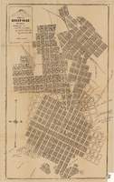
Map of Goldfield, Nevada, April 25, 1907
Date
1907-04-25
Description
'Compiled by James H. Parks, U.S. Deputy Min. Sur., Box 655, Goldfield, Nev. April 25, 1907.' 'Nevada Press Company, Carson City, Nevada.' Scale: [ca. 1:4,800] 1 inch = 400 ft. Plat map. Library's copy has notes handwritten in pencil along right margin with arrows to locations on map: "Ramsey Street ended Columbia St." "MacMaskrs office." "Lived on Euclid ave in adobe house." " Lived in Tent House Sundog Ave."
Image
Map of the 450 foot level of the Mohawk Mine, Goldfield, Nevada, circa 1902-1908
Date
1902 to 1908
Description
'(3rd) 450 Ft. level Mohawk.' Hand-drawn, hand-colored and annotated map showing the 450 foot, or third, level of the Mohawk Mine.
Image
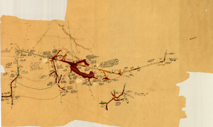
Map of the 280 foot level of the Combination Mine, Goldfield, Nevada, circa 1902-1908
Date
1902 to 1908
Description
Hand-drawn, hand-colored and annotated map showing the 280 foot level of the Combination Mine. Printed on map: 'Mohawk, col. el. 5958.48; Hayes & Monnette No. 2, col. el. 5935.7; Hayes & Monnette No. 1, col. el. 5925.8; Truett, col. el. 5938.8; Combination, col. el. 5986.31.'
Image