
Search the Special Collections and Archives Portal

Search Results

Display    Results Per Page
Displaying results 151 - 160 of 194

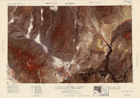
Satellite image map of the Las Vegas Valley, 1981

Date

1981

Description

'1981. Experimental edition 36114-A1-SI-250.' Scale 1:250,000 ; Transverse Mercator proj. (W 116°--W 114°/N 37°--N 36°). Series: Western United States 1:250,000. Western United States 1:250,000 ; NJ 11-12. Filing title: Las Vegas, Nev.; Ariz.; Calif. 'Imagery recorded with Multispectral Scanner (MSS) on NASA Landsat-3.' Includes image coverage diagram. Separate map on verso: Las Vegas / prepared by the U.S. Army Topographic Command ; revised by the U.S. Geological Survey 1969. Ed. 5. Washington, D.C. : Geological Survey, 1976, NJ 11-12 in the series Western United States 1:250,000. United States Geological Survey

Image

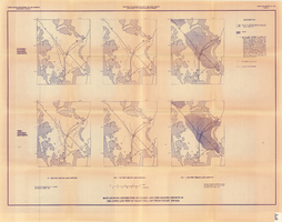
Maps showing distribution of coarse- and fine-grained deposits in the upper 1,000 feet of valley fill, Las Vegas Valley, Nevada, 1981 (Open-file report 84-130, plate 3)

Date

1981

Description

'United States Department of the Interior, Geological Survey. Open-file report 84-130, plate 3.' 'Prepared in cooperation with the Clark County Department of Comprehensive Planning.' 'Base from U.S. Geological Survey, 1:250,000, Las Vegas and Kingman, 1969.' 'Geology from Malmberg (1965); Longwell and others (1965); and J. R. Harrill, 1979. Lithology by R.W. Plume, 1981.' Contents: Coarse-grained deposits: 0-200 feet below land surface; 200-700 feet below land surface; 700-1,000 feet below land surface -- Fine-grained deposits: 0-200 feet below land surface; 200-700 feet below land surface; 700-1,000 feet below land surface. Scale [ca. 1:310,464. 1 in.=approx. 4.9 miles]. Series: Open-file report (Geological Survey (U.S.))84-130 Originally published as plate 3 of Ground-water conditions in Las Vegas Valley, Clark County, Nevada. Part I. Hydrogeologic framework / by Russell W. Plume, published by the U.S. Geological Survey in 1984 as Open-file report 84-130.

Image

Map showing railroads in Nevada, 1911

Date

1911

Description

Relief shown by hachures. Title below scale: Rand McNally & Co.'s New business atlas map of Nevada. Shows railroads. Includes township and range grid. Includes index to principal cities with population statistics. Includes township and range grid. Index to Nevada counties, lakes, mountains, rivers, towns, etc. on verso. Published by Rand McNally & Co. Scale [ca. 1,710,720]. 1 in. = 27 miles (W 120°--W 114°/N 42°--N 35°). Published as page 321 of Rand-McNally indexed atlas.

Text

Map showing detailed topography of the country traversed by the reconnaissance expedition through southern & southeastern Nevada, 1869

Date

1869

Description

At top of map: 'Reconnaissance Maps, Department of California.' In lower right corner: 'Photolith. by the N.Y. Lithg. Engrg. & Prtg. Co.' 'In charge of, Lieut. Geo. M. Wheeler, U.S. Engineers; assisted by Lieut. D.W. Lockwood, Corps of Engineers,U.S.A., 1969.' 'P.W. Hamel, chief topographer and draugthsman.' 'Officially compiled and published at the Engineer Office, Head Quarters Department of California in 1869 and 70 by order of Brigadier General E.O.C. Ord. Comm'dg. [signed] Geo. M. Wheeler, Lieutenant of Engineers In Charge, Head Quarters Dept. of Cal. Oct. 26th, 1870.' Includes information from railroad maps, the United States Geological Survey of the 40th parallel and from Lieutenant Ives' explorations along the Colorado. Map includes camps, astronomical stations, good and bad wagon roads, trails, springs, settlements, mining districts, state and county boundaries and the watershed between the Humboldt and Colorado Basin. Shows most of eastern half of Nevada. Relief shown by hachures and spot heights. Scale: [1:760,320]. 1 in. to approx. 12 miles. (W 117°00´--W 113°00´/N 41°45´--N 35°45´). Series: Reconnaissance maps. Military map / Department of Californiano. 1.miles. Library's copy has counties hand-outlined in colored markers.

Image

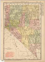
Map of southern California and southern Nevada, 1872

Date

1872

Description

'Entered according to Act of Congress in the year 1872 by Asher & Adams in the office of the Librarian of Congress at Washington.' Scale [ca. 1:1,267,300]. 1 in. to 20 miles (W 124°--W 114°/N 42°--N 32°). Shows natural features, populated places, county boundaries and railroads Prime meridians: Greenwich and Washington. In top margins: 95-96 (south portion). Shows range and township grid. Hand colored. Asher & Adams.

Image

Topographic map of the Las Vegas Valley area, 1959

Date

1959

Description

Scale 1:250,000 ; Transverse Mercator proj. (W 116°--W 114°/N 37°--N 36°) ; 1 map : col. ; 45 x 72 cm ; Relief shown by contours and spot heights. Contour interval 200 feet ; Margin title ; "Compiled in 1955 by photogrammetric methods by U.S. Coast and Geodetic Survey and from Nevada 1:48,000 and 1:62,500, USGS, 1952-54, and Nevada 1:50,000, CE, 1952. Planimetric detail revised by photo-planimetric methods. Horizontal and vertical control by USGS, USC& GS, and CE. Photography field annotated 1954. Road data 1954." ; Shows townships and ranges ; Gives 1955 declination from true north ; Includes location diagram, reliability diagram, and sectionalized township map ; Filing title: Las Vegas, Nevada; Arizona; California ; Interior--Geological Survey

Image

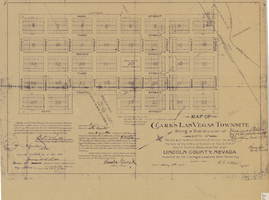
Map of Clark's Las Vegas Townsite, May 8, 1905

Date

1905-05-08

Description

'Book 1, Page 37.' 'Dated: May 8th, 1905.' Subtitle: 'Being a sub-division of parts of the W.1/2 and the W.1/2 of the N.E.1/4 of Section 34 and the S.1/2 of the S.W.1/4 of Section 27 T.20 S.R. 61 E, Mount Diablo Base and Meridian, Lincoln County, Nevada. A Plat map. Blueline print. Scale [ca. 1:2,400]. 1 in. to 200 feet.

Text

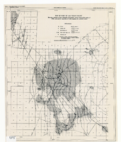
Map of part of Las Vegas Valley showing contours of the composite piezometric surface during the spring of 1944, and specific capacities of wells tapping the confined water

Date

1948

Description

Relief shown by contours. Includes range and township grid. Shows springs and wells. Scale [ca. 1:67,162. 1 in. to approx. 1.06 miles]. Series: Water resources bulletin (Carson City, Nev.)
no. 5. Originally published as plate 8 in Geology and water resources of Las Vegas, Pahrump, and Indian Spring Valleys, Clark and Nye Counties, Nevada by George B. Maxey and C.H. Jameson, which is number 5 of the Water resources bulletin published by the Nevada Office of the State Engineer.

Image

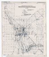
Map of part of Las Vegas Valley showing the piezometric surface of the "near-surface" water during the spring of 1946 by contours, and areas of discharge by evaporation and transpiration

Date

1946

Description

Relief shown by contours. Includes range and township grid. Shows springs, wells and areas of discharge. Scale [ca. 1:67,162. 1 in. to approx. 1.06 miles]. Series: Water resources bulletin (Carson City, Nev.)
no. 5. Originally published as plate 7 in Geology and water resources of Las Vegas, Pahrump, and Indian Spring Valleys, Clark and Nye Counties, Nevada by George B. Maxey and C.H. Jameson, which is number 5 of the Water resources bulletin published by the Nevada Office of the State Engineer.

Image

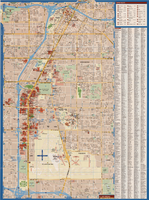
Maps of Las Vegas metropolitan area, Grand Canyon National Park and national parks near Las Vegas, Nevada, 2008

Date

2008

Description

'Cartography, H. Frommer, J. Habersetzer, R. Jendrzejewski, K. Berndtson, M. Grünke, P. Heine, K. Borch. ' On map verso: statistics on Las Vegas, U.S. time zones, maps of Las Vegas and region, Las Vegas and national parks, Grand Canyon National Park, and Grand Canyon Village. Relief is show by shading and colors on Las Vegas & national parks and Grand Canyon National Park maps. Index terms are in English, German, French, Italian, and Spanish. Includes inset map of Grand Canyon Village. Shows casinos, tourist attractions, shows, public buildings, shopping malls, parks, and golf courses. Original publisher: Borch GmbH. 7th ed. '1:20 000.' Original map is laminated.

Text