Search Results
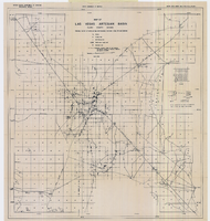
Map of Las Vegas artesian basin, Clark County, Nevada, April 1946 (Water Resources Bulletin no. 4, plate 1)
Date
1946-04
Description
'April, 1946.' 'Showing location of wells, springs, and boundary between valley fill and bedrock.' Originally published as plate 1 in number 4 of the Water resources bulletin published by the Nevada Office of the State Engineer. Scale [ca. 1:63,360. 1 in. to approx. 1 mile] (W 115°10?--N 115°/N 36°20?--N 36°). G4354.L3C34 1946 .N482
Image

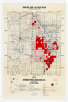
Map of Las Vegas Valley artesian basin, circa 1940
Date
1938 to 1942
Description
Scale [ca. 1:72,000. 1 in.=approx. 6,000 feet] (W 115°10´--W 115°/N 36°20´--N 36´). Shows wells, springs, boundary between valley fill and bedrock, and ground water district boundaries for Las Vegas Metropolitan Area and North Las Vegas. "Figure 1." Nevada. State Engineer
Image
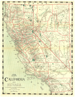
Map of California and Nevada, 1907
Date
1907
Description
Col. ; 57 x 43 cm., folded to 15 x 6 cm. Relief shown by hachures and spot heights. Published and copyrighted bu H.A. Candrian, 1907. "Mrs. H.A. Candrian, Dr'ng"--lower left corner.
Image
Map showing home-site lands in the Las Vegas Valley, 1955
Date
1955
Description
Scale [1:84,269. 1 in. to 1 1/3 miles] ; 1 map : col. ; 57 x 50 cm. on sheet 89 x 59 cm ; Cadastral map ; Gives definition of township, section and acre ; Relief shown by form lines and spot heights ; Shows private land, land classified for small tracts, leased land, vacant Federal land, section numbers, number of acres in each homesite and purchase price of tract ; "From your Congressman Cliff Young."--stamped on map ; Southern Nevada Home-Siters
Image
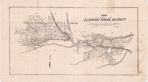
Map of a portion of the Eldorado Mining District, November 1916
Date
1916-11
Description
'Edition No. 2. November 1916.' Map is one side of a folded flyer advertising mines and mining in the Eldorado Canyon district. Transporation options to the area are listed. Scale: 1" = 1000'.
Text

Map of underground workings in Potosi and Central Lodes, May 1906
Date
1906-05
Description
'Scale 20 ft = 1 in.'
Image

Map showing plan for water quality management update for wastewater collection systems in the Las Vegas Valley, February 20, 1997
Date
1997-02-20
Description
'Plate 1. Source: Clark County Geographic Information Systems Central Repository. Comprehensive Planning, Advanced Planning Division. Feburary 20, 1997.' Scale [ca. 1:95, 040. 1 in.=approx. 1.5 miles]. Shows sewers, force mains, service area boundaries, watershed boundaries, and lift stations. Includes inset location map. Includes township and range grid. Clark County, Nevada, Comprehensive Planning, Advanced Planning Division.
Image
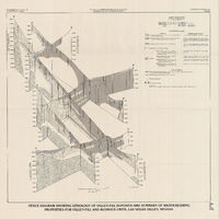
Cross-sections of wells and aquifers in the Las Vegas Valley, circa 1946
Date
1943 to 1949
Description
2 map sections on 1 sheet. Originally published as plate 6 in Geology and water resources of Las Vegas, Pahrump, and Indian Spring Valleys, Clark and Nye Counties, Nevada by George B. Maxey and C.H. Jameson, which is number 5 of the Water resources bulletin published by the Nevada Office of the State Engineer. Shows permeable and impermeable materials, wells, and aquifers.
Text
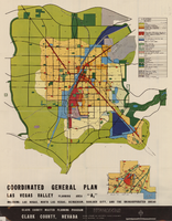
Map showing coordinated general plan for Las Vegas Valley, Planning Area A5, circa 1965-1968
Date
1963 to 1970
Description
Subtitle:'Including Las Vegas, North Las Vegas, Henderson, Boulder City, and the unincorporated areas.' 'Clark County Master Planning Program, Clark County, Nevada.' 'Eisner-Stewart and Associates, Planning Consultants, South Pasadena, California.' Includes inset of Boulder City. Text on verso about the general plan for the Las Vegas Valley, Clark County Master Planning Program Area. Published between 1965 and 1968? Scale [ca. 1:84,269. 1 inch to approximatley 1 1/3 miles].
Text
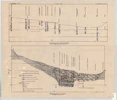
Fence diagram showing lithology of valley-fill deposits and summary of water-bearing properties for valley-fill and bedrock units, Las Vegas Valley, Nevada, 1981 (Water-supply paper 2320-A)
Date
1981
Description
'Department of the Interior, U.S. Geological Survey. Water-supply paper 2320-A, plate 2.' 'Prepared in cooperation with the Clark County Department of Comprehensive Planning.' 'Geology by R.W. Plume, 1981.' Scale [ca. 1:95,040. 1 in.=approx. 1.5 miles]. Series: U.S. Geological Survey water-supply paper2320-A. Originally published as plate 2 of Ground-water conditions in Las Vegas Valley, Clark County, Nevada. Part I. Hydrogeologic framework / by Russell W. Plume, published by the U.S. Geological Survey in 1989 as Water-supply paper 2320-A. "Prepared in cooperation with the Clark County Department of Comprehensive Planning."
Text