Search Results
Warburgs Bridge Kort, undated
Level of Description
Item
Archival Collection
Harrah’s Entertainment Corporate Archives
To request this item in person:
Collection Number: MS-00460
Collection Name: Harrah’s Entertainment Corporate Archives
Box/Folder: Box 107 (Restrictions apply)
Collection Name: Harrah’s Entertainment Corporate Archives
Box/Folder: Box 107 (Restrictions apply)
Archival Component
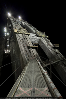
Photograph of the walkway to the Mike O'Callaghan-Pat Tillman Memorial Bridge arch from the Nevada side of the bridge while under construction, September 10, 2009
Date
2009-09-10
Archival Collection
Description
Photographer's notes: "Walkway to the arch from near the Nevada side hairpin, September 10, 2009." Site Name: Mike O'Callaghan-Pat Tillman Memorial Bridge
Image
Operation Bridge program, 1974
Level of Description
File
Archival Collection
Robert Ranney Collection on the Children's Service Guild of Southern Nevada
To request this item in person:
Collection Number: MS-00334
Collection Name: Robert Ranney Collection on the Children's Service Guild of Southern Nevada
Box/Folder: Box 2
Collection Name: Robert Ranney Collection on the Children's Service Guild of Southern Nevada
Box/Folder: Box 2
Archival Component
Washout at end of bridge, 1938
Level of Description
File
Archival Collection
Union Pacific Railroad Photographs
To request this item in person:
Collection Number: PH-00043
Collection Name: Union Pacific Railroad Photographs
Box/Folder: Oversized Box 01
Collection Name: Union Pacific Railroad Photographs
Box/Folder: Oversized Box 01
Archival Component
Bridge 468.06, 1938
Level of Description
File
Archival Collection
Union Pacific Railroad Photographs
To request this item in person:
Collection Number: PH-00043
Collection Name: Union Pacific Railroad Photographs
Box/Folder: Oversized Box 01
Collection Name: Union Pacific Railroad Photographs
Box/Folder: Oversized Box 01
Archival Component
Bridge, Yuma, Arizona, 1870s
Level of Description
File
Archival Collection
Elbert Edwards Photograph Collection
To request this item in person:
Collection Number: PH-00214
Collection Name: Elbert Edwards Photograph Collection
Box/Folder: Folder 12
Collection Name: Elbert Edwards Photograph Collection
Box/Folder: Folder 12
Archival Component
View of Waterfront with PR bridge: photographic print
Date
1870 (year approximate) to 1979 (year approximate)
Archival Collection
Description
From the KLVX Steamboats on the Colorado Photograph Collection (PH-00156)
Image
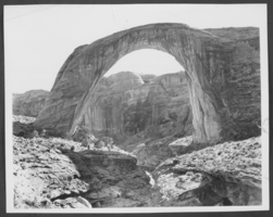
Photograph of Rainbow Bridge National Monument, Utah, June 22, 1976
Date
1976-06-22
Archival Collection
Description
A picture of Rainbow Bridge, known as the world's highest natural bridge, by Lake Powell in Utah.
Image
Under the Manhattan Bridge, 2004
Level of Description
File
Archival Collection
Guide to the Canadian Film Centre Worldwide Short Film Festival Submissions
To request this item in person:
Collection Number: MS-00615
Collection Name: Guide to the Canadian Film Centre Worldwide Short Film Festival Submissions
Box/Folder: Box 2004-036
Collection Name: Guide to the Canadian Film Centre Worldwide Short Film Festival Submissions
Box/Folder: Box 2004-036
Archival Component
Coopers/ Bridges Fight, 2002
Level of Description
File
Archival Collection
Guide to the Canadian Film Centre Worldwide Short Film Festival Submissions
To request this item in person:
Collection Number: MS-00615
Collection Name: Guide to the Canadian Film Centre Worldwide Short Film Festival Submissions
Box/Folder: Box 2004-005
Collection Name: Guide to the Canadian Film Centre Worldwide Short Film Festival Submissions
Box/Folder: Box 2004-005
Archival Component