Search Results
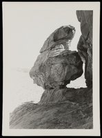
Photograph of Adeline Rock, Lost City (Nev.), May 14, 1933
Date
1933-05-14
Archival Collection
Description
Adeline Rock at Valley of Fire, May 14, 1933.
Image
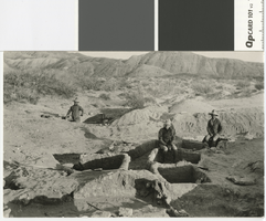
Photograph of excavations in process at the Lost City near St. Thomas, Nevada, circa 1925
Date
1925 (year approximate)
Archival Collection
Description
Transcribed Notes: Transcribed from handwritten inscription by D. Hancock on back of postcard: "This shows some of the excavators at work at the Buried City or 'Lost City' as it is sometimes called. This is near St. Thomas if you wish to look up its approximate location on the map. It was here I went last Spring on one of my trips."
Image
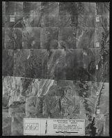
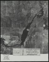
Aerial view of the Bonelli quadrant in Arizona-Nevada: photographic print
Date
1950
Archival Collection
Description
From the Army Mapping Service Aerial Photographs of Southern and Western Nevada (PH-00285). Aerial photographs, composites, and indices. High altitude aerial photographs, Quad. Bonelli, State: Arizona - Nevada. U.S. Geological Survey, Army Map Service. Flight Scale I-47200Project-GS-LJ. Index copied -8-26-50. Flying Comp. -7-26-50
Image
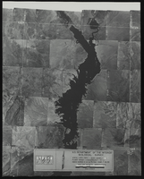
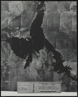
Aerial view of the Bonelli quadrant in Arizona-Nevada: photographic print
Date
1950
Archival Collection
Description
From the Army Mapping Service Aerial Photographs of Southern and Western Nevada (PH-00285). Aerial photographs, composites, and indices. Aerial photographs, Quad. Bonelli 4, U.S. Department of the Interior Geological Survey, Army Map Service. State: Arizona - Nevada. Flight Scale I-47200Project-GS-LJ. Index copied -8-26-50. Flying Comp. -7-26-50
Image
Aerial view of the Bonelli quadrant in Arizona-Nevada: photographic print
Date
1952
Archival Collection
Description
From the Army Mapping Service Aerial Photographs of Southern and Western Nevada (PH-00285). Aerial photographs, composites, and indices. High altitude aerial photographs, Quad. Bonelli 3, State: Arizona - Nevada. U.S. Geological Survey, Army Map Service. Flight Scale I-47200Project-GS-LJ. Index copied -8-26-50. Flying Comp. -7-26-50
Image
Discover NV Lost City: VHS videotape, approximately 1995 to 1996
Level of Description
Item
Archival Collection
William Mors Audiovisual Collection
To request this item in person:
Collection Number: MS-01147
Collection Name: William Mors Audiovisual Collection
Box/Folder: Box 26
Collection Name: William Mors Audiovisual Collection
Box/Folder: Box 26
Archival Component
Painting of the Lost City, Nevada: photographic print, approximately 1935 to 1959
Level of Description
Item
Archival Collection
UNLV Libraries Single Item Accession Photograph Collection
To request this item in person:
Collection Number: PH-00171
Collection Name: UNLV Libraries Single Item Accession Photograph Collection
Box/Folder: Folder 16
Collection Name: UNLV Libraries Single Item Accession Photograph Collection
Box/Folder: Folder 16
Archival Component
View of Lost City, Nevada: photographic print, approximately 1930 to 1959
Level of Description
Item
Archival Collection
UNLV Libraries Single Item Accession Photograph Collection
To request this item in person:
Collection Number: PH-00171
Collection Name: UNLV Libraries Single Item Accession Photograph Collection
Box/Folder: Folder 16
Collection Name: UNLV Libraries Single Item Accession Photograph Collection
Box/Folder: Folder 16
Archival Component
Waters of Lake Mead rise to base of Lost City Restorations, 1939
Level of Description
File
Archival Collection
Elbert Edwards Photograph Collection
To request this item in person:
Collection Number: PH-00214
Collection Name: Elbert Edwards Photograph Collection
Box/Folder: Folder 06
Collection Name: Elbert Edwards Photograph Collection
Box/Folder: Folder 06
Archival Component