Search Results
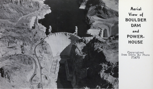
Postcard showing an aerial view of Hoover Dam, circa late 1930s
Date
1936 to 1939
Archival Collection
Description
Text on right side of postcard reads: "Aerial view of Boulder Dam and powerhouse." Boulder Dam was officially re-named Hoover Dam in 1947.
Image
Aerial views of the Dunes golf course and the airport: video, approximately 1980 to 1989
Level of Description
File
Scope and Contents
Aerial views of McCarran International Airport and repeated 360 views of the Dunes golf course and surrounding area. Original media 1 Inch SMPTE Type B, color, aspect ratio 4 x 3, frame size 720 x 486.
Archival Collection
The Production Company Audiovisual Collection
To request this item in person:
Collection Number: MS-00930
Collection Name: The Production Company Audiovisual Collection
Box/Folder: Digital File 00
Collection Name: The Production Company Audiovisual Collection
Box/Folder: Digital File 00
Archival Component
Aerial photograph of Kiel Ranch, 1974 May 15
Level of Description
File
Archival Collection
North Las Vegas Bicentennial Committee Photographs and Drawings of Kiel Ranch
To request this item in person:
Collection Number: PH-00005
Collection Name: North Las Vegas Bicentennial Committee Photographs and Drawings of Kiel Ranch
Box/Folder: Folder 01
Collection Name: North Las Vegas Bicentennial Committee Photographs and Drawings of Kiel Ranch
Box/Folder: Folder 01
Archival Component
Photograph of Saltaire surrounded by water, aerial view, undated
Level of Description
Item
Archival Collection
Young Electric Sign Company (YESCO) Corporate Records
To request this item in person:
Collection Number: MS-00403
Collection Name: Young Electric Sign Company (YESCO) Corporate Records
Box/Folder: Box 13
Collection Name: Young Electric Sign Company (YESCO) Corporate Records
Box/Folder: Box 13
Archival Component
Aerial photograph of Circus Circus construction site, Las Vegas, Nevada, 1967-1968
Date
1967 to 1968
Archival Collection
Description
Aerial view of Circus Circus construction site looking southwest on the Las Vegas Strip, with outline of the "big top" area at the left (east). The Westward Ho Motel is seen immediately above the site and the Stardust (fifteen rectangular buildings) and Frontier (two "wings") hotels are also seen (to the southwest). Site Name: Circus Circus (Las Vegas, Nev.)
Image
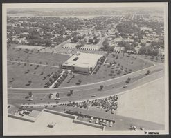
Aerial photograph of Civic Center Drive and North Las Vegas City Hall, May 23, 1970
Date
1905-05-23
Archival Collection
Description
An aerial view of the North Las Vegas City Hall and Civic Center Drive.
Image
Aerials day shots of the Las Vegas Valley: video, 1988 March 01
Level of Description
File
Scope and Contents
Aerial day shots of the Las Vegas valley; includes the Strip, Desert Shores, Cashman field, and other locations across the valley. Original media U-matic S, color, aspect ratio 4 x 3, frame size 720 x 486.
Archival Collection
The Production Company Audiovisual Collection
To request this item in person:
Collection Number: MS-00930
Collection Name: The Production Company Audiovisual Collection
Box/Folder: Digital File 00
Collection Name: The Production Company Audiovisual Collection
Box/Folder: Digital File 00
Archival Component
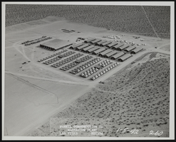
Photograph of aerial view of building boarding camps, Henderson (Nev.), January 5, 1942
Date
1942-01-05
Archival Collection
Description
Aerial view looking east, showing temporary boarding camp.
Image
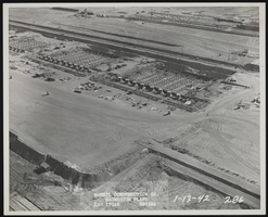
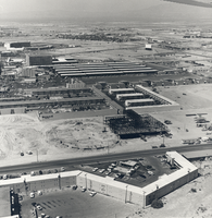
Photograph of aerial view of plant construction, Henderson (Nev.), January 13, 1942
Date
1942-01-13
Archival Collection
Description
Aerial view looking southeast, showing metal plant units 1, 2, and 3.
Image

Aerial photograph of Nellis Air Force Base and gasoline tank farm, Nevada, June 5, 1973
Date
1973-06-05
Archival Collection
Description
Aerial view of Nellis Air Force Base (Nevada) with a gasoline tank farm in the background. Site Name: Nellis Air Force Base (Nev.)
Image