Search Results
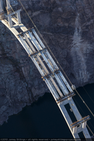
Photograph showing an aerial view of the twelve central girders installed to support the Mike O'Callaghan-Pat Tillman Memorial Bridge deck, Nevada-Arizona border, February 3, 2010
Date
Archival Collection
Description
Image
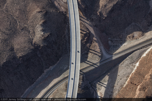
Photograph showing an aerial view of cars driving on the road constructed for the Hoover Dam Bypass Project, Arizona side of Hoover Dam, January 14, 2011
Date
Archival Collection
Description
Image
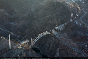
Photograph showing an aerial view of the twelve central girders installed to support the Mike O'Callaghan-Pat Tillman Memorial Bridge deck, Nevada-Arizona border, February 3, 2010
Date
Archival Collection
Description
Image
Photograph showing an aerial view of the twelve central girders installed to support the Mike O'Callaghan-Pat Tillman Memorial Bridge deck, Nevada-Arizona border, February 3, 2010
Date
Archival Collection
Description
Image

Photograph showing an aerial view of the twelve central girders installed to support the Mike O'Callaghan-Pat Tillman Memorial Bridge deck, Nevada-Arizona border, February 3, 2010
Date
Archival Collection
Description
Image
Aerial photograph of Las Vegas, Nevada. Pictured from left to right: the Sands (partially visible), the Flamingo, and the Dunes, 1955
Level of Description
Archival Collection
Collection Name: Mary and Arthur Ackerman Aerial Photograph Collection
Box/Folder: Folder 01
Archival Component
Aerial photograph of Las Vegas, Nevada. The Dunes Hotel and Casino is pictured in the center with the Flamingo Hotel and Casino to the left, 1955
Level of Description
Archival Collection
Collection Name: Mary and Arthur Ackerman Aerial Photograph Collection
Box/Folder: Folder 01
Archival Component

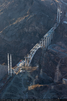
Photograph showing an aerial view of the structurally complete Mike O'Callaghan-Pat Tillman Memorial Bridge, Colorado River, Hoover Dam, and Lake Mead, July 27, 2010
Date
Archival Collection
Description
Image

Photograph of an aerial view of the Mount Diablo Mine Company buildings, Pickhandle Gultch (Nev.), 1891
Date
Archival Collection
Description
Image
Aerial views of UNLV and the Las Vegas strip during day and night; Scott Lyon playing golf: video, 1988 September 01
Level of Description
Scope and Contents
Aerial footage of Las Vegas, Nevada during the daytime, flys over UNLV with stadium area and Thomas and Mack visible; them turns and heads to Las Vegas Boulevard and goes north along the Strip starting at Tropicana and goes all the way to downtown/Fremont Street, where it turns around and heads back down Las Vegas Boulevard going south; sun is setting at this point. The helicopter continues to loop up and down the STrip as the sun sets and skies are eventually dark. Second segment starts around 26:00 is Scott Lyon playing golf with a few other individuals; Las Vegas Hilton is seen in the background, close up on the golf score card, ends with Lyon walking with golf clubs towards a building with golf carts parked next to it. Original media 1 Inch SMPTE Type B, color, aspect ratio 4 x 3, frame size 720 x 486.
Archival Collection
Collection Name: The Production Company Audiovisual Collection
Box/Folder: Digital File 00
Archival Component