Search Results

Aerial photograph showing the Basic Magnesium Inc. plant site, Henderson, Nevada, October 29, 1941
Date
Archival Collection
Description
Air view showing Basic Magnesium Inc. plant site excavation with the administration building in foreground, looking southeast to Railroad Pass.
Transcribed Notes: Transcribed from front of photo: "McNeil construction Co. Magnesium plant, Las Vegas, Nevada, 10-29-41"
Image
Villa Latina: conceptual master plan aerial to south building rendering, 2005 October to 2006 March
Level of Description
Archival Collection
Collection Name: Domingo Cambeiro Corporation Architectural Records
Box/Folder: Roll 38
Archival Component
Boulder Grove site plan, topographic map, and aerial rendering created by Alan L. Blum Associates, 1983
Level of Description
Archival Collection
Collection Name: UNLV University Libraries Collection of Boulder City, Hoover Dam, and Lake Mead National Recreation Area Maps and Brochures
Box/Folder: Flat File 05
Archival Component

Aerial photograph of North Las Vegas flood control channel under I-15 and Civic Center Drive, June 5, 1973
Date
Archival Collection
Description
Flood control channel crossing I-15 and Civic Center Drive, Bullock's Feed and Tack store nearby.
Transcribed Notes: Notes from photo sleeve: "Aerial photo: Looking southeast. North Las Vegas flood control channel crosses I-15 and Civic Center Drive with Bulloch's Feed and Tack store next to channel. June 5, 1973." Stamped on back: "CNLV Engineering Dept." Notes on back: "Looking SE NLV Flood Control channel crosses I-15 and Civic Center Drive with Bullocks Feed and Tack store next to channel"
Image

Aerial photograph showing the Lake Mead intake for the Basic Magnesium Inc. water system, Nevada, December 30, 1941
Date
Archival Collection
Description
Aerial view showing site of Basic Magnesium's water supply intake at Lake Mead.
Transcribed Notes: Transcribed from front of photo: " Basic Magnesium, Inc., Acting for and in behalf of Defense Plant Corp. Plancor 201, Engineers LTD. Contractor, For water services, Las Vegas, Nevada, 12-30-41" Transcribed from photo sleeve: "Air view showing site of water supply intake. Intake structure and pumphouse to be built on point of island (at right center). Causeway between island and mainland in center. BMI, 12-30-41"
Image
Aerial view of Las Vegas Strip from the Dunes Hotel and Tally Ho looking South, undated
Level of Description
Archival Collection
Collection Name: Ruthe Scott Photographs of Las Vegas, Nevada Hotels and Casinos
Box/Folder: Box SH-028
Archival Component
#69134: Aerial photos of several locations on the Main Campus, on May 21, 2013, 2013 May 21
Level of Description
Archival Collection
Collection Name: University of Nevada, Las Vegas Creative Services Records (2010s)
Box/Folder: Digital File 00
Archival Component
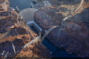
Photograph showing an aerial view of the Mike O'Callaghan-Pat Tillman Memorial Bridge, Hoover Dam, Colorado River, and Lake Mead, September 10, 2009
Date
Archival Collection
Description
Image
Duff's Island Saginaw Industrial Park: oversized prints of an aerial perspective rendering, 1966 February 18
Level of Description
Archival Collection
Collection Name: Frank Reynolds Professional Papers
Box/Folder: Roll 25 (Restrictions apply), Oversized Box 40 (Restrictions apply)
Archival Component

Aerial photo of the power block at the Crescent Dunes Solar concentrated solar power plant near Tonopah, Nevada: digital photograph
Date
Archival Collection
Description
Photographer's assigned keywords: "110 megawatts; CSP; Concentrated Solar Energy; Concentrated Solar Power; Crescent Dunes; NV; Nevada; Solar Reserve; SolarReserve; Tonopah; aerial; concentrated solar thermal; green energy; molten salt; renewable energy; storage; tower."
Image