Search Results
Power production and system testing at Crescent Dunes Solar, near Tonopah, Nevada: digital photograph
Date
2015-10-09
Archival Collection
Description
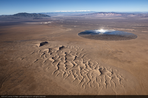
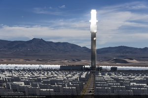
Photographer's note: "Aerial photograph of Crescent Dunes Solar, a 110MW tower style concentrated solar power plant with molten salt storage near Tonopah, Nevada, USA. On this day, the system was being tested by heating molten salt at the top of the glowing tower to 1050°F (566°C), then using the resultant thermal energy to drive steam turbines, which in turn sent electrical power to the Nevada grid.."
Photographer's assigned keywords: "110 megawatts; CSP; Concentrated Solar Energy; Concentrated Solar Power; Crescent Dunes; NV; Nevada; Solar Reserve; SolarReserve; Tonopah; aerial; concentrated solar thermal; green energy; molten salt; renewable energy; storage; tower."
Photographer's assigned keywords: "110 megawatts; CSP; Concentrated Solar Energy; Concentrated Solar Power; Crescent Dunes; NV; Nevada; Solar Reserve; SolarReserve; Tonopah; aerial; concentrated solar thermal; green energy; molten salt; renewable energy; storage; tower."
Image
Power production and system testing at Crescent Dunes Solar, near Tonopah, Nevada: digital photograph
Date
2015-10-09
Archival Collection
Description
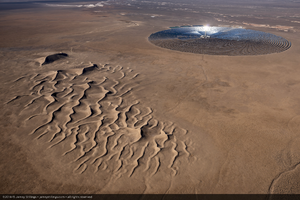
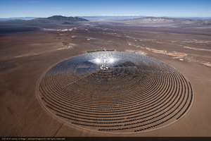
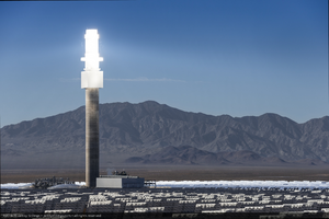
Photographer's note: "Aerial photograph of Crescent Dunes Solar, a 110MW tower style concentrated solar power plant with molten salt storage near Tonopah, Nevada, USA. On this day, the system was being tested by heating molten salt at the top of the glowing tower to 1050°F (566°C), then using the resultant thermal energy to drive steam turbines, which in turn sent electrical power to the Nevada grid.."
Photographer's assigned keywords: "110 megawatts; CSP; Concentrated Solar Energy; Concentrated Solar Power; Crescent Dunes; NV; Nevada; Solar Reserve; SolarReserve; Tonopah; aerial; concentrated solar thermal; green energy; molten salt; renewable energy; storage; tower."
Photographer's assigned keywords: "110 megawatts; CSP; Concentrated Solar Energy; Concentrated Solar Power; Crescent Dunes; NV; Nevada; Solar Reserve; SolarReserve; Tonopah; aerial; concentrated solar thermal; green energy; molten salt; renewable energy; storage; tower."
Image

Topographic map of the southeast quadrangle of the metropolitan Las Vegas, Nevada area, 1984
Date
1984
Description
Scale 1:24,000 ; polyconic proj. (W 115°0730--W 115°0000/N 36°0730--N 36°0000) ; 1 map : col. ; 58 x 47 cm ; 7.5 minute series (topographic) ; Relief shown by contours and spot heights ; Filing title: Las Vegas SE, Nev ; "DMA 2956 II SE--Series V896." ; Contour interval 20 feet ; "Topography by photogrammetric methods from aerial photographs taken 1965. Field checked 1967." ; "Revisions shown in purple and woodland compiled from aerial photographs taken 1982 and other sources. This information not field checked. Map edited 1984." ; Includes quadrangle location map ; Interior--Geological Survey
Image
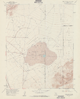
Topographic map of Frenchman Flat quadrangle, Nevada, 1960
Date
1960
Description
'Mapped, edited, and published by the Geological Survery in cooperation with the Atomic Energy Commission. Control by USGS, USC&GS, USCE, and Atomic Energy Commission. Topography from aerial photographs by photogrammetric methods. Aerial photographs taken 1959. Field check 1960.' Scale 1:24,000 polyconic projection (W 116°00'00"--W 115°52'30"/N 36°52'30"--N 36°45'00"). Series: 7.5 minute series (topographic). Relief shown by contours and spot heights. Filing title: Frenchman Flat, Nev. Contour interval 20 feet. opography rom . Includes quadrangle location map. Interior--Geological Survey
For sale by the U.S. Geological Survey
For sale by the U.S. Geological Survey
Image

Photograph of F-100A fighter aircraft in flight, Nellis Air Force Base, Las Vegas, circa 1950s
Date
1953 to 1959
Archival Collection
Description
Black and white image of a fighter aircraft in flight. Additional description from UNLV Special Collections: Nellis Early Days-3595th Pilot Training Wing 1948/1958, North American F-100A 53-1542, 53-1543, 53-1544, 52-1552. Site Name: Nellis Air Force Base (Nev.)
Image