Search Results
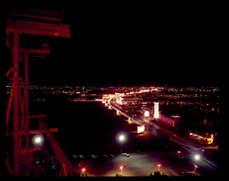
An aerial view of the Las Vegas Strip at night: photographic film
Date
1960 (year approximate) to 1986 (year approximate)
Archival Collection
Description
An aerial view of the Las Vegas Strip at night taken from the Hotel Flamingo looking north. For a southern view see Source ID 0220_0015, Digital ID pho026249.
Image
#16427 "Joe McNamee Aerials" wide view aerials circling downtown Las Vegas showing developed and undeveloped areas: aerial photographs, 1976 March 04
Level of Description
File
Archival Collection
Frank Mitrani Photographs
To request this item in person:
Collection Number: PH-00332
Collection Name: Frank Mitrani Photographs
Box/Folder: Box 76
Collection Name: Frank Mitrani Photographs
Box/Folder: Box 76
Archival Component
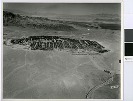
Aerial photograph of Boulder City, circa 1949
Date
1949 (year approximate)
Archival Collection
Description
Aerial view looking north of Boulder City.
Transcribed Notes: Transcribed from handwritten notes on back: "View N-ward"
Image
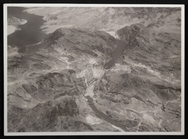
Aerial photograph of downstream face of Hoover Dam, circa 1933-1935
Date
1933 to 1935
Archival Collection
Description
Aerial view of the nearly completed Hoover Dam in Black Canyon prior to the release of water.
Image
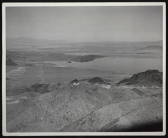
Photograph of an aerial view of Lake Mead, circa 1934-1950s
Date
1934 to 1959
Archival Collection
Description
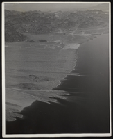
An image showing an aerial view of Lake Mead amidst its home of rocky terrain. Varying rocky roads can be seen etched into the reservoir's shore.
Image
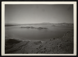
Photograph of an aerial view of Lake Mead, circa 1934-1950s
Date
1934 to 1959
Archival Collection
Description
An image showing an aerial view of Lake Mead amidst its home of rocky terrain. Varying rocky roads can be seen etched into the reservoir's shore.
Image
Photograph of an aerial view of Lake Mead, circa 1934-1950s
Date
1934 to 1959
Archival Collection
Description
An image showing an aerial view of Lake Mead amidst its home of rocky terrain. Varying rocky roads can be seen etched into the reservoir's shore.
Image
Aerial footage of Las Vegas Strip: video
Date
1998
Archival Collection
Description
Aerial b-roll footage of the Las Vegas Strip (day) starting near Mandalay Bay and Luxor and looking north to Stratosphere; aerial views (dusk/night) of the Strip starting near the Stratosphere looking south, Stardust and Treasure Island, the Rio, Mirage, MGM, Excalibur, Luxor, and Mirage volcano show. Video cuts in and out for the last four minutes. Unclear if aerial footage is from KTNV or UNLV. Original media Betacam SP, color, aspect ratio 4 x 3, frame size 720 x 486. From the UNLV TV Audiovisual Collection (UA-00098) – Digitized audiovisual material file.
Moving Image
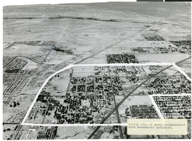
Aerial photograph of North Las Vegas, Nevada, June 5, 1973
Date
1973-06-05
Archival Collection
Description
Aerial view of North Las Vegas, Nevada, with boundaries of "model neighborhood" marked in white. Handwritten on back of photograph: "Corner of Main St. and Las Vegas Blvd. North (No. 5th St.). Model neighborhood includes most of original NLV Williams additions." Label at lower right of photo:"Aerial view of Model Neighborhood with boundaries indicated."
Image
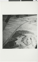
Photograph of aerial view of the Flamingo, Las Vegas (Nev.), circa 1947
Date
1946 to 1948
Archival Collection
Description
Black and white aerial view of the Flamingo hotel and casino on the Las Vegas strip. Site Name: Flamingo Hotel and Casino (Las Vegas, Nev.)
Image