Search Results


#66545: Rebel Connection (2008) - Give Back Service Project, 2008 August 22
Level of Description
File
Archival Collection
University of Nevada, Las Vegas Creative Services Records (2000s)
To request this item in person:
Collection Number: PH-00388-04
Collection Name: University of Nevada, Las Vegas Creative Services Records (2000s)
Box/Folder: N/A
Collection Name: University of Nevada, Las Vegas Creative Services Records (2000s)
Box/Folder: N/A
Archival Component
Transportation System Projects Fiscal Years 2010-2019 (Draft), 2009 July 22
Level of Description
File
Archival Collection
Bruce Turner Collection on Transportation and Water in Southern Nevada
To request this item in person:
Collection Number: MS-00648
Collection Name: Bruce Turner Collection on Transportation and Water in Southern Nevada
Box/Folder: Digital File 00, Box 14
Collection Name: Bruce Turner Collection on Transportation and Water in Southern Nevada
Box/Folder: Digital File 00, Box 14
Archival Component

Map showing U.S. Bureau of Reclamation Region 3 projects in Arizona, California, Nevada, New Mexico and Utah, September 1967
Date
1967-09
Description
'United States, Department of the Interior, Stewart L. Udall, Secretary. Bureau of Reclamation, Floyd E. Dominy, Commissioner.' 'Map. No. X-300-738. September 1967.' Scale [ca. 1:1,774,080] (W 119°--W 108°/N 39°--N 32°). Relief shown pictorially. Shows completed, under construction and proposed dams and reservoirs, canals, and aqueducts, power plants, pumping plants, substations, transmission lines, tunnels and siphons. Also shows non-Bureau of Reclamation dams, reservoirs, tunnels, pipelines and irrigated lands. Includes inset map of location of Region 3 and key map of drainage basins. Bureau of Reclamation, [Region 3?].
Image
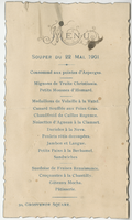
Unknown restaurant, dinner menu, May 22, 1901
Date
1901-05-22
Archival Collection
Description
Location: 50 Grosvenor Square, London, England
Text