Search Results
Su Kim Chung with the Dennis McBride queer archive at the University of Nevada, Las Vegas Lied Library Special Collections Department: digital image, 2016 February 29
Level of Description
Item
Archival Collection
Dennis McBride Photograph Collection
To request this item in person:
Collection Number: PH-00263
Collection Name: Dennis McBride Photograph Collection
Box/Folder: Digital File 00
Collection Name: Dennis McBride Photograph Collection
Box/Folder: Digital File 00
Archival Component
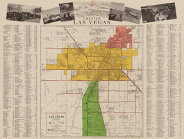
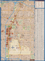
General map of Las Vegas, Nevada, circa 1957
Date
1955 to 1959
Description
'Compiled and issued by the Campbell Realty Company.' At top pf map: ' Greater Las Vegas.' Shows names of housing tracts and locations of hotels and motels on the Las Vegas Strip. Includes indexes and photographs of local recreation and attractions. Originally published by Campbell Realtydistributed by Las Vegas Nevada Chamber of Commerce . Scale (ca. 1:39,000. 1 in. to approx. 3,250 ft.].
Text
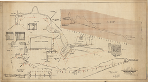
Map showing proposed improvements of Las Vegas Springs, Las Vegas, Nevada, January 26, 1918
Date
1918-01-26
Archival Collection
Description
'Exhibit A'. 'Approved Jan. 26, 1918.' Includes discharge figures and plans for improvements to springs for the municipal water system including diagrams of spillway openings, etc. Scale [ca. 1:1200] 1 in.=100 feet -- Scale [ca. 1:120] 1 in.=10 feet -- Scale [ca. 1:240] 1 in.=20 feet -- Scale [ca. 1:24] 1 in.=2 feet -- Scale [ca. 1:2400] 1 in.=200 feet. Vertical scale [ca. 1:48] 1 in.=4 feet -- Scale [ca. 1:12] 1 in.=1 foot.
Image
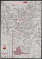
Map of metropolitan Las Vegas, Nevada, 1971
Date
1971
Description
At top of map: 'Avis Rent a Car System.' 'Copyright The H.M.Gousha Company... San Jose, Calif.' '8-SS-1044-S.' Scale [ca. 1:43,718]. 1 in. equals approx 0.69 miles. On verso: map of 'Las Vegas [and] Lake Mead Recreational Area, 1971 edition'; map of McCarran International Airport ('1274-S'); and list of Avis Rent A Car locations. H.M. Gousha Co.
Text
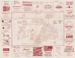
Map of the city of Las Vegas, 1953
Date
1953
Description
24 x 38 cm. on sheet 43 x 56 cm., folded to 28 x 13 cm. Includes advertisements for Las Vegas businesses. Advertisements for Las Vegas businesses, inset map of North Las Vegas, and index on verso. Copyright held by Redwood Pub. Co. Includes inset map of the Strip (U.S. 91 or Los Angeles Highway). Map is irregularly shaped. Original publisher: Redwood Pub. Co..
Image
CBS fires vice president who said Vegas victims didn't deserve sympathy because country music fans 'often are Republican' | Fox News: archived website, 2017
Level of Description
Other Level
Archival Collection
Web Archive on the October 1, 2017 Shooting in Las Vegas, Nevada
To request this item in person:
Collection Number: MS-00866
Collection Name: Web Archive on the October 1, 2017 Shooting in Las Vegas, Nevada
Box/Folder: N/A
Collection Name: Web Archive on the October 1, 2017 Shooting in Las Vegas, Nevada
Box/Folder: N/A
Archival Component
Maps of Las Vegas metropolitan area, Grand Canyon National Park and national parks near Las Vegas, Nevada, 2008
Date
2008
Description
'Cartography, H. Frommer, J. Habersetzer, R. Jendrzejewski, K. Berndtson, M. Grünke, P. Heine, K. Borch. ' On map verso: statistics on Las Vegas, U.S. time zones, maps of Las Vegas and region, Las Vegas and national parks, Grand Canyon National Park, and Grand Canyon Village. Relief is show by shading and colors on Las Vegas & national parks and Grand Canyon National Park maps. Index terms are in English, German, French, Italian, and Spanish. Includes inset map of Grand Canyon Village. Shows casinos, tourist attractions, shows, public buildings, shopping malls, parks, and golf courses. Original publisher: Borch GmbH. 7th ed. '1:20 000.' Original map is laminated.
Text

Topographic map of Nevada-California, Las Vegas quadrangle, March 1908
Date
1908-03
Description
'Edition of Mar. 1908.' 'E.M. Douglas, geographer in charge; Topography and triangulation by R.H. Chapman, B.D. Stewart, J.E. Blackburn, and D.F.C. Moor. Surveyed in 1906-1907.' Scale 1:250,000 (W 116°00--W 115°00/N 37°00--N 36°00). Relief shown by contours and spot heights. Title in lower-right corner: Las Vegas. Contour interval 100 feet. Datum is mean sea level. "Topography"--Center of top margin. Text about the Topographic Maps of the United States series and symbols used on map on verso. U.S. Geological Survey
Text
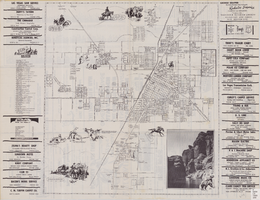
Street map of the city of Las Vegas, North Las Vegas, the "Strip", 1955
Date
1955
Description
41 x 38 cm., folded to 28 x 15 cm. Panel title: Welcome map, greater Las Vegas area. Includes inset map of Meikle Manor subdivision. Includes list of churches in Las Vegas, mileages from Las Vegas to other cities in the Southwest and notes. Helldorado ed. 1955. Map is irregularly shaped. Index and advertisements on verso. Original publisher: Adco Publishing Co..
Image
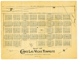
Map of Clark's Las Vegas Townsite, Lincoln County, Nevada, May 10, 1905
Date
1905-05-10
Archival Collection
Description
Scale: 1" = 100'. 1 map ; 28 x 22 cm. Verso of map is an announcement of the auction to be held May 15, 1905, for lots in the Las Vegas townsite. Pricing and lot information is included, as well as specials for railway tickets to Las Vegas from Los Angeles and Salt Like City. Las Vegas Land and Water Company
Text