Search Results
andrew clark on Twitter: "Thousands in line to give blood. And car after car donating food and drinks. #thisisvegas #HomeMeansNevada #VegasStrong #PrayForVegas https://t.co/dbAIqpGhQ1": archived website, 2017
Level of Description
Archival Collection
Collection Name: Web Archive on the October 1, 2017 Shooting in Las Vegas, Nevada
Box/Folder: N/A
Archival Component

Plat of H.F.M & M addition to city of Las Vegas, Clark County, Nevada, comprising the west 1/2 of N.W. 1/4 Sec. 27, Twp. 20 S., R. 61 E., M.D.B & M, March 8, 1924
Date
Description
Image
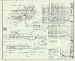
Architectural drawing of additions and alterations to the mens' and womens' health clubs in the Sands Hotel, Las Vegas, Nevada, April 19, 1965
Date
Description
Floor plans, sections, elevations for mens' and womens' health clubs at the Sands Hotel, Las Vegas, Nevada. Includes door and finish schedules. "Sheet no. 17A. Job no. 420. Drawn by Shoji Yasuda. Job captain, Mas Tokubo. 2-26-65. Revised 4-19-65."
Site Name: Sands Hotel
Address: 3355 Las Vegas Boulevard South;
Image
UNLV Libraries Collection of Digital Communication about COVID-19 in Las Vegas
Identifier
Abstract
UNLV Libraries Collection of Digital Communication about COVID-19 in Las Vegas (2020-2021) contain digital materials documenting the COVID-19 pandemic at the University of Nevada, Las Vegas (UNLV) and in Las Vegas, Nevada. The collection materials include archived websites, Twitter data, and official emails sent to the UNLV campus community.
Archival Collection

Map showing profile of 24-inch cast iron water pipeline for Las Vegas, Nevada, May 20, 1930
Date
Archival Collection
Description
Image
Correspondence, memoranda, surveys of other Nevada repositories women's collections, University Library Society minutes, newspaper clippings, Nevada Women's Archives newsletters, University of Nevada, Las Vegas (UNLV) Library Planning minutes, 1998 Women's History Month programs and correspondence, 1994-1998
Level of Description
Archival Collection
Collection Name: Nevada Women's Archives Records
Box/Folder: Box 02
Archival Component
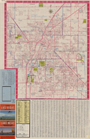
Las Vegas street map and Lake Mead Recreation Area pictorial map, 1979
Date
Description
Text

Plan of proposed new well pipe and fittings for Las Vegas, Nevada, 1936
Date
Archival Collection
Description
Image

Map of Boulder Dam area and Las Vegas, Nevada, October 7, 1930
Date
Description
Text
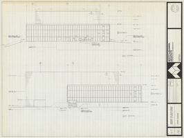
Architectural drawing of Performing Arts Center, Phase II, University of Nevada, Las Vegas, exterior elevations, July 31, 1974
Date
Archival Collection
Description
East and south exterior elevations of Performing Arts Center (later to become the Judy Bayley Theatre), University of Nevada, Las Vegas. Scale: 1/8" = 1'-0". "Drawn by J.A.L. Checked by O.D.S. Job no. 720. Date 7-31-74." "Sheet A-7 of 28."
Site Name: University of Nevada, Las Vegas
Address: 4505 S. Maryland Parkway
Image