Search Results
Dennis McBride and Su Kim Chung with the Dennis McBride queer archive at the University of Nevada, Las Vegas Lied Library Special Collections Department: digital image, 2016 February 29
Level of Description
Item
Archival Collection
Dennis McBride Photograph Collection
To request this item in person:
Collection Number: PH-00263
Collection Name: Dennis McBride Photograph Collection
Box/Folder: Digital File 00
Collection Name: Dennis McBride Photograph Collection
Box/Folder: Digital File 00
Archival Component
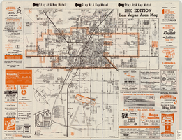
Las Vegas area map, 1960
Date
1960
Description
1960 ed. Scale [ca. 1:47,520. 1 in. equals approx. 0.75 miles.] 1 map : col. ; 41 x 43 cm., folded to 22 x 10 cm. Panel title: Welcome map : greater Las Vegas area and scenic routes to and from there. "1960-61 edition."--Panel. Irregularly-shaped map. Includes list of Las Vegas schools, inset maps of East Las Vegas (Whitney) and Wherry housing area on Nellis Air Force Base and advertisements for Las Vegas businesses. Index, mileages from cities in the United States to Las Vegas and sightseeing information on verso. Library's copy 1 has some art work and some lettering in orange and has "Las Vegas Nevada Chamber of Commerce" stamped in purple on panel. Library's copy 2 has some art work and some lettering in purple and has "Pioneer Title Insurance Co. of Nevada" stamped in black on panel. Nevada State Motel Association?
Text

Map of Las Vegas Valley, Clark County, Nevada, 1954
Date
1954
Description
Scale [ca. 1:63,360. 1 in. to approx. 5,280 ft.].Cadastral map. 'Compiled for C.D. Baker, Reg. Civil Engineer Nevada No. 6 and Licensed Real Estate Broker by Tyson Engineering Co., Las Vegas, Nevada.' 'Copyright 1954 Tyson Engineering Co., Las Vegas, Nevada. Drawn by E.M. Ballinger' Tyson Engineering Company
Image

Map of Las Vegas, Nevada and surrounding Bureau of Land Management areas to the west and north, 1994
Date
1994
Description
'BLM edition, 1994.' 'Surface management status; mineral management status.' '1:100,000-scale topographic map showing highways, roads and other manmade structures; water features; contours and elevations in meters with conversions to feet; BLM recreation sites.' 'Edited and published by the Bureau of Land Management. Base map prepared by the U.S. Geological Survey.' I53:11/4-2
Text