Search Results
United Way of Southern Nevada - Supporting Our Community Through the COVID-19 Crisis: archived website, 2020 to 2021
Level of Description
Archival Collection
Collection Name: UNLV Libraries Collection of Digital Communication about COVID-19 in Las Vegas
Box/Folder: N/A
Archival Component
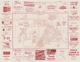
Map of the city of Las Vegas, 1953
Date
Description
Image
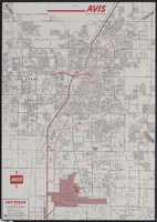
Map of metropolitan Las Vegas, Nevada, 1971
Date
Description
Text
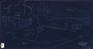
Blueprint showing proposed improvement of Las Vegas Springs, Las Vegas, Nevada, September 21, 1916
Date
Archival Collection
Description
'Exhibit A'. 'Approved Sept. 21, 1916.' '2-N-1719' handwritten in lower right corner. 'W.E.J."--Lower left corner. "L-44 - 50 to 61. T-75 - 17 & 46"--Upper left corner. Includes discharge figures and plans for improvements to springs. Scale [ca. 1:240]. 1 in. to 20 feet. -- Scale [ca. 1:2,400]. 1 in. to 200 ft. Vertical scale [ca. 1:48]. 1 in. to 4 feet. -- Scale [ca. 1:4,800]. 1 in. to 100 feet. 1 map. Contents: Detail at springs -- Profile -- Alignment.
Image
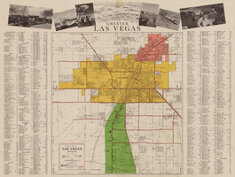
General map of Las Vegas, Nevada, circa 1957
Date
Description
distributed by Las Vegas Nevada Chamber of Commerce . Scale (ca. 1:39,000. 1 in. to approx. 3,250 ft.].
Text
CBS fires vice president who said Vegas victims didn't deserve sympathy because country music fans 'often are Republican' | Fox News: archived website, 2017
Level of Description
Archival Collection
Collection Name: Web Archive on the October 1, 2017 Shooting in Las Vegas, Nevada
Box/Folder: N/A
Archival Component
Collin Rugg on Twitter: "Absolutely horrifying footage of an active shooter in Las Vegas. Stay safe everyone! https://t.co/6pjEy4nMEa": archived website, 2017
Level of Description
Archival Collection
Collection Name: Web Archive on the October 1, 2017 Shooting in Las Vegas, Nevada
Box/Folder: N/A
Archival Component

Map showing location of the Las Vegas & Tonopah Railroad from Las Vegas to Bullfrog, Nevada, 1906
Date
Archival Collection
Description
Image

Topographic map of Nevada-California, Las Vegas quadrangle, 1951
Date
Description
Image
Chinese Immigration and Chinese in the United States compiled by Waverly B. Lowell for the National Archives and Records Administration, 1996
Level of Description
Archival Collection
Collection Name: Sue Fawn Chung Collection on Asians in Nevada
Box/Folder: Box 03
Archival Component