
Search the Special Collections and Archives Portal

Search Results

Display    Results Per Page
Displaying results 1001 - 1010 of 598322

Hotel El Rancho Vegas, wine list

Date

1950 (year approximate) to 1980 (year approximate)

Description

Note: Photographs of hotel on back of menu. Cover has illustration of woman in cowgirl costume, operating a wine press, with the hotel in the background Menu insert: Wine lists; Advertisements Restaurant: El Rancho Vegas Location: On Highway 91, Las Vegas, Nevada, United States

Text

@_SierraMistt_ on Twitter: "Never in the history of ever has the strip been so empty https://t.co/gY9cWxP1jM": archived website, 2017

Level of Description

Other Level

Archival Collection

Web Archive on the October 1, 2017 Shooting in Las Vegas, Nevada
To request this item in person:
Collection Number: MS-00866
Collection Name: Web Archive on the October 1, 2017 Shooting in Las Vegas, Nevada
Box/Folder: N/A

Archival Component

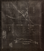
Topographic map showing proposed reservoir for the Las Vegas Rancho, August 4, 1931

Date

1931-08-04

Description

'Chief Engineers Office, Los Angeles, Calif. August 4, 1931. Scale: 1"=100'. Drawn by L.P.D. 1"=10'.' Accompanies: Letter from R. L. Adamson to F. H. Knickerbocker, August 18, 1931 (Folder 6B: 18-1-9).

Image

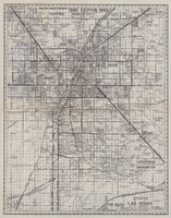
Map of the city of Las Vegas, Nevada, June 1, 1946

Date

1946-06-01

Description

Scale [ca. 1:9,600. 1 in. to approx. 800 ft.]. Cadastral map. 'Compiled by Pioneer Title Insurance &Trust Company.' 'By Jack Asher, State Nev. Reg. Engr. No. 305.' 'Issue 5, 6/1/46.' Includes indexes. Pioneer Title Insurance &ampTrust Company

Image

Topographic map of groundwater in the southeast quadrangle of Las Vegas, Nevada, 1980

Date

1980

Description

'Las Vegas Area Map 3Af.' 'Prepared in cooperation with U.S. Geological Survey.' 'Water Resources Division, U.S. Geological Survey, Carson City, Nevada.' 'Topographic base from U.S. Geological Survey, Las Vegas SE 7 1/2 quadrangle, 1967.' Scale 1:24,000 (W 115°07'30"--W 115°00'00"/N 36°07'30"--N 36°00'00"). Series: Las vegas area map ; 3Af. Urban area maps. Las Vegas area map ; 3Af. Relief shown by contour lines and spot heights. Title in margins of map: Las Vegas SE quad. : ground water. Title on publications list on Nevada Bureau of Mines and Geology website: Groundwater map of the Las Vegas SE quadrangle. Series: Urban area maps [Las Vegas area map] from publications list on Nevada Bureau of Mines and Geology website. Nevada Bureau of Mines and Geology

Text

Map of Las Vegas and vicinity, Clark County, Nevada, December 1954

Date

1954-12

Description

'1955 map of Las Vegas and vicinity, Clark County, Nevada.' '4th issue, December 1954.' Cadastral map..

Image

Map of Las Vegas Valley artesian basin, circa 1940

Date

1938 to 1942

Description

Scale [ca. 1:72,000. 1 in.=approx. 6,000 feet] (W 115°10´--W 115°/N 36°20´--N 36´). Shows wells, springs, boundary between valley fill and bedrock, and ground water district boundaries for Las Vegas Metropolitan Area and North Las Vegas. "Figure 1." Nevada. State Engineer

Image

Map of city of Las Vegas, Nevada, October 1, 1940

Date

1940-10-01

Description

'Compiled by C.D. Baker, Oct. 1, 1940.' Scale [ca. 1:11,400]. 1 in. to 950 ft. Cadastral map.

Image

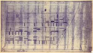
Plat of original townsite of Las Vegas, Clark County, Nevada, November 25, 1927

Date

1927-11-25

Description

Subtitle: 'On N 1/2 of SW 1/4 section 27, T 20 S, R 61 E, M.D. Mer. showing cast iron water mains. Including location and distances of valves, fire hydrants, house connections, etc. Constructed by Las Vegas Land &Water Company. Construction completed Nov. 25-1927. Cast iron pipe system throughout made at Provo, Utah by Pacific States Cast Iron Pipe Company. R.N. Clark, Construction Engineer. Map and survey made by J.T. McWilliams, C.E., Las Vegas, Nev.' Map shows ownership of some parcels of land. Scale [ca. 1:960]. 1 inch to 80 feet. Blueline print. Plat map.

Image

Map of greater Las Vegas, 1960

Date

1960

Description

55 x 44 cm., folded to 30 x 12 cm. Relief shown by spot heights. Includes notes and quotations. Includes indexes. Panel title: Front Boy's official 1962-1963 edition street map: detailed guide of North Las Vegas, Las Vegas, Paradise Valley and vicinity. 1962-1963 ed. Original publisher: Front Boy Service Co..

Image