Search the Special Collections and Archives Portal
Search Results
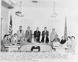
Film transparency of the Boulder City, Nevada Charter Committee, December 1958
Date
1958-12
Archival Collection
Description
Black and white image of the Nevada Charter Committee with the following printed description: Shown are the members of Boulder City, Nevada, Charter Committee. Seated left to right, Thomas S. White, M.D., Morgan J. Sweeney, Clarence Arp, Andrew J. Mitchell, Robert N. Broadbent, Richard Ham, Joe Manix, Jane Cooke, Teresa Denning, and Eloise Blue; standing, Elbert B. Edwards, Byron L. Miller, Albert Franklin, A. B. West and Thomas Clapper.
Image
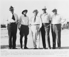
Film transparency of Hoover Dam affiliated businessmen and engineers, Boulder City, Nevada, July 1931
Date
1931-07
Archival Collection
Description
Black and white image of businessmen and engineers affiliated with Hoover Dam. From left to right: W. A. Bechtel, First Vice President, Six Companies, Inc.; Walker R. Young, Construction Engineer, Bureau of Reclamation; Elwood Mead, Commissioner, Bureau of Reclamation, F. T. Crowe, General Superintendent, Six Companies, Inc.; R. F. Walter, Chief Engineer, Bureau of Reclamation. Note: Boulder Dam was officially renamed Hoover Dam in 1947.
Image
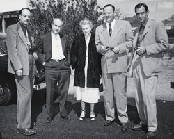
Film transparency of the Chamber of Commerce and Area-Wide Committee representatives and others at the Boulder City, Nevada airport April 30, 1952
Date
1952-04-30
Archival Collection
Description
The pictured Chamber of Commerce and Area-Wide Committee representatives met undersecretary Richard Searles, Senator Ernest W. McFarland, Reclamation Commissioner Michael Straus, and others at the Boulder City, Nevada airport April 30, 1952. From left to right: Max Kelch (chairman of the area-wide committee), Elton M. Garrett (secretary of the area-wide committee), Lillian Collins (secretary of the Boulder City Chamber of Commerce), Earl Brothers, Chester K. Tyree (President of the Boulder City Chamber of Commerce).
Image

Film negative of Mayor Oran K. Gragson seated at his desk in City Hall, Las Vegas, Nevada, December 21, 1967
Date
1967-12-21
Archival Collection
Description
Las Vegas Mayor Oran K. Gragson seated at his desk in City Hall. The man standing next to him is unidentified. A certificate From Delta dated June 25, 1961 hangs on the wall behind him. Oran Kenneth Gragson (February 14, 1911 – October 7, 2002) was an American businessman and politician. He was the longest-serving mayor of Las Vegas, Nevada, from 1959 to 1975. Gragson, a member of the Republican Party, was a small business owner who was elected Mayor on a reform platform against police corruption and for equal opportunity for people of all socio-economic and racial categories. Gragson died in a Las Vegas hospice on October 7, 2002, at the age of 91. The Oran K. Gragson Elementary School located at 555 N. Honolulu Street, Las Vegas, NV 89110 was named in his honor.
Image
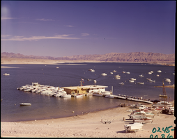
Film transparency of Las Vegas Bay, Lake Mead, Nevada, 1961
Date
1961
Archival Collection
Description
Boats are moored at the marina, as well as offshore. Some boats are on the beach, waiting to launch. A few small islands are visible in the background. Las Vegas Bay is a bay at the western edge of Lake Mead, to the northeast of the city of Henderson, Nevada, near the junction of Lake Mead Drive and Lake Mead Boulevard. A public campground and boat access are available in Las Vegas Bay. Low water levels of Lake Mead have rendered the marina there inoperable, and it relocated to the Hemenway Boat Harbor, in the south end of the Boulder Basin in 2002. The launch ramp there has also been closed due to the water levels. The Lake Mead Marina was relocated to the Hemenway Boat Harbor in 2008. The bay is the natural discharge point for the Las Vegas Wash. Las Vegas Wash is in the southeastern portion of the Las Vegas Valley and is approximately 12 miles long, from its headwaters northwest of Las Vegas to its mouth at Las Vegas Bay on the western portion of Lake Mead. The bridge across the Wash on Northshore Road is approximately 1.2 miles north of the intersection of Lakeshore and Northshore Roads.
Image
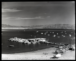
Film transparency of Las Vegas Bay, Lake Mead, Nevada, 1961
Date
1961
Archival Collection
Description
Boats are moored at the marina, as well as offshore. Some boats are on the beach, waiting to launch. A few small islands are visible in the background. Las Vegas Bay is a bay at the western edge of Lake Mead, to the northeast of the city of Henderson, Nevada, near the junction of Lake Mead Drive and Lake Mead Boulevard. A public campground and boat access are available in Las Vegas Bay. Low water levels of Lake Mead have rendered the marina there inoperable, and it relocated to the Hemenway Boat Harbor, in the south end of the Boulder Basin in 2002. The launch ramp there has also been closed due to the water levels. The Lake Mead Marina was relocated to the Hemenway Boat Harbor in 2008. The bay is the natural discharge point for the Las Vegas Wash. Las Vegas Wash is in the southeastern portion of the Las Vegas Valley and is approximately 12 miles long, from its headwaters northwest of Las Vegas to its mouth at Las Vegas Bay on the western portion of Lake Mead. The bridge across the Wash on Northshore Road is approximately 1.2 miles north of the intersection of Lakeshore and Northshore Roads.
Image
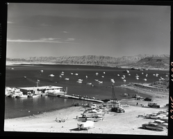
Film transparency of Las Vegas Bay, Lake Mead, Nevada, 1961
Date
1961
Archival Collection
Description
Boats are moored at the marina, as well as offshore. Some boats are on the beach, waiting to launch. A few small islands are visible in the background. Las Vegas Bay is a bay at the western edge of Lake Mead, to the northeast of the city of Henderson, Nevada, near the junction of Lake Mead Drive and Lake Mead Boulevard. A public campground and boat access are available in Las Vegas Bay. Low water levels of Lake Mead have rendered the marina there inoperable, and it relocated to the Hemenway Boat Harbor, in the south end of the Boulder Basin in 2002. The launch ramp there has also been closed due to the water levels. The Lake Mead Marina was relocated to the Hemenway Boat Harbor in 2008. The bay is the natural discharge point for the Las Vegas Wash. Las Vegas Wash is in the southeastern portion of the Las Vegas Valley and is approximately 12 miles long, from its headwaters northwest of Las Vegas to its mouth at Las Vegas Bay on the western portion of Lake Mead. The bridge across the Wash on Northshore Road is approximately 1.2 miles north of the intersection of Lakeshore and Northshore Roads.
Image
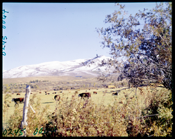
Film transparency of cattle grazing in a field, possibly in Lamoille Valley, Nevada, 1971
Date
1971
Archival Collection
Description
Cattle grazing in a field, possibly in Lamoille Valley, Nevada. Lamoille is located in Elko County, Nevada. It is located about 17 miles (27 km) east of Elko at the base of the Ruby Mountains at an elevation of 5,889 feet (1,795 m) and is part of the Elko Micropolitan Statistical Area. The early history of the community and surrounding area is summarized in a nearby highway marker. John Walker and Thomas Waterman first settled the area in 1865. Waterman named the valley after his native Vermont. In 1868, Walker erected the Cottonwood Hotel, store and blacksmith shop in the valley, and the settlement became known as "The Crossroads." Here wagons were repaired and food and supplies could be obtained. The original buildings and the more recent 20-bedroom Lamoille hotel, creamery, flour mill and dance hall are gone. Lamoille is nestled off the western flanks of the Ruby Mountains at the end of Nevada State Route 227, and is the principal gateway to this range via the National Forest Scenic Byway up Lamoille Canyon.
Image

Film transparency of the mountains near Virginia City, Nevada, circa 1940s
Date
1940 to 1949
Archival Collection
Description
The mountains near Virginia City, Nevada. Virga can be seen falling from the clouds. Like many cities and towns in Nevada, Virginia City was a mining boomtown; it developed virtually overnight as a result of miners rushing to the Comstock Lode silver strike of 1859 on the eastern slopes of Mount Davidson. But, Virginia City far surpassed all others for its peak of population, technological advancements developed there, and for providing the population base upon which Nevada qualified for statehood. The riches of the Comstock Lode inspired men to hunt for silver mines throughout Nevada and other parts of the American West. At its peak, Virginia City had a population of over 25,000 residents and was called the richest city in America. Dominated by San Francisco moneyed interests, Virginia City was heralded as the sophisticated interior partner of San Francisco. “San Francisco on the coast and Virginia City inland” became the mantra of west coast Victorian entrepreneurs. Early Virginia City settlers were in large part the backwash from San Francisco and the California Gold Rush, ten years before. Mine owners who made a killing in the Comstock mines spent most of their wealth in San Francisco.
Image
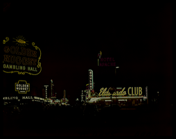
Film transparency of Fremont Street at night, Las Vegas, Nevada, July, 1949
Date
1949-05
Archival Collection
Description
Fremont Street at night. Visible on the left side of the street are neon signs for the Golden Nugget Gambling Hall, Nugget Saloon, Frontier Club, The White Spot Cafe, Pioneer Club, The Monte Carlo Club, The Union Pacific sign (in the background, right of center). Visible on the right side of the street are neon signs for the Vegas Club, Hotel Apache, and the Eldorado Club. The Golden Nugget opened in 1946, and is the first structure designed from the ground up to be a casino. Steve Wynn became the majority shareholder in 1973, and built the first tower in 1977. In 1984, the neon was removed from the building and the spa tower was built, along with the showroom. The third tower was opened in 1989. The hotel now has 2,419 rooms and suites. The casino's large hotel sign at its entrance off Fremont and Casino Center was removed in 1984 when the casino underwent renovations. The old sign presently sits at the YESCO (Young Electric Sign Company) sign yard.
Image
Pagination
Refine my results
Content Type
Creator or Contributor
Subject
Archival Collection
Digital Project
Resource Type
Year
Material Type
Place
Language
Records Classification
