
Search the Special Collections and Archives Portal

Search Results

Display    Results Per Page
Displaying results 280951 - 280960 of 285945

Map to accompany agreement with Willie T. Stewart, Vernon E. Bunker, Earl Leavitt and William Udell Stewart covering lease of Las Vegas Ranch property at Las Vegas, Nevada, January 31, 1951

Date

1951-01-31

Description

'Las Vegas Land and Water Company, Exhibit A.' 'Office of Vice President, Los Angeles, Califormia. January 31, 1951.' Accompanies document: "N"L.D. 2454 (text of lease of the Las Vegas Ranch) (Box 11 Folder W18-1-12). Scale: 1" = 600'.

Image

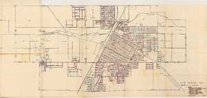
Map of Las Vegas Valley Water District, December 29, 1952

Date

1952-12-29

Description

'Exhibit A.' 'Dec. 29, 1952.' 'I-128.' Scale [ca. 1:3,600]. 1 in.=300 feet. Shows water pipelines, other parts of the water system, and power lines to be removed or relocated when land is sold to the Las Vegas Valley Water District. Shows land to be sold and lists power requirements for water system. Includes township and range lines. Library's copy includes hand-written notations and calculations. Los Angeles & Salt Lake Railroad Company, Office of Vice President?

Image

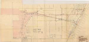
Map showing various facilities of the Las Vegas Land and Water Company, March 1, 1953

Date

1953-03-01

Description

'Exhibit C.' 'March 1, 1953.' 'I-67.' Scale [ca. 1:7,200] 1 in.=600 feet. Map shows facilities [mainly water-pipes] of Las Vegas Land and Water Company completed and those under construction as of September 1, 1952, and facilities which were commenced after September 1, 1952, and prior to March 1, 1953. Map made as part of the papers for the sale of Las Vegas Land and Water Company facilities to the Las Vegas Valley Water District. Shows township and range lines. Library's copy has hand-written notes in pencil. Las Vegas Land and Water Company?

Image

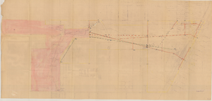
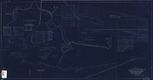
Map showing location of water-bearing lands to be sold to the Las Vegas Valley Water District, March 1, 1953

Date

1953

Description

'Exhibit A.' 'March 1, 1953.' 'I-128.' Shows location of water-bearing lands to be sold to the Las Vegas Valley Water District and the boundary of lands owned by Union Pacific which are not to be sold to the district. The Union Pacific Railroad Company owned the Las Vegas Land and Water Company. Also shows pipes, proposed pipes, other parts of the water system, power lines, and lists power requirements for water system. Includes township and range lines. Las Vegas Land and Water Company

Image

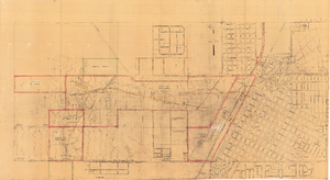
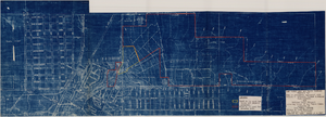
Map of Las Vegas showing areas owned by the Union Pacific Railroad Company, water pipes and other water utilities, circa 1942

Date

1938 to 1946

Description

Map showing downtown Las Vegas and tracts to the west showing water supply lines, wells, springs, and settling basins. Various areas outlined in red and yellow. Scale [ca. 1:7,200] 1 in.=600 feet. Cadastral map. Blueline print. Areas owned by railroad outlined by hand in different colored markers. Library's copy includes hand-written calculations.

Image

Blueprint map showing proposed water pipeline from Big Spring to Las Vegas, Nevada, January 24, 1911

Date

1911-01-24

Description

'S.P.L.A.&S.L.R.R. Los Angeles Division. Map of pipe line from Big Spring. Las Vegas, Nev. Approved: Jan. 24, 1911. E.M. Jessup, E.M. of W.' In lower right corner: '4-U-323.' Scale [ca. 1:2,400] 1 in.=200 feet. Relief shown by contours. North is to upper right.

Image

Map to accompany joint letter dated April 20th, 1931 to Mr. Gray concerning construction of proposed water main to serve lessees in Industrial Unit No. 1, Las Vegas, Nevada, April 20, 1931

Date

1931-04-20

Description

'Union Pacific System. Los Angeles & Salt Lake Railraod Company.' 'Office of Industrial Engr., Los Angeles, California, April 20th, 1931. Dwg. No. 588.' Scale: 1" = 200'.

Image

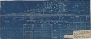
Blueprint showing proposed improvement of Las Vegas Springs, Las Vegas, Nevada, September 21, 1916

Date

1916-09-21

Description

'Exhibit A'. 'Approved Sept. 21, 1916.' '2-N-1719' handwritten in lower right corner. 'W.E.J."--Lower left corner. "L-44 - 50 to 61. T-75 - 17 & 46"--Upper left corner. Includes discharge figures and plans for improvements to springs. Scale [ca. 1:240]. 1 in. to 20 feet. -- Scale [ca. 1:2,400]. 1 in. to 200 ft. Vertical scale [ca. 1:48]. 1 in. to 4 feet. -- Scale [ca. 1:4,800]. 1 in. to 100 feet. 1 map. Contents: Detail at springs -- Profile -- Alignment.

Image

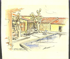
Pastel sketch of the swimming pool at the ranch. "Cupid's Spot on the Desert": design drawings

Date

1880 to 1979

Description

Bell Family Scrapbook scanning, Set 4, proofed 11.04.2010 Pastel sketch of the swimming pool at the ranch. Cupid's Spot on the Desert." Artist is Pierre M. Artigue. Rendering is prior to the addition of wing with master bedroom and boys bedroom. Date is unknown but artist died in 1934 and house was built in 1931/1932

Image

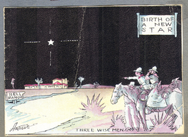
Color-tinted postcard showing the Walking Box Ranch, Nevada

Date

1880 to 1979

Description

Bell Family Scrapbook scanning, Set 4, proofed 11.04.2010 Color-tinted postcard showing the Walking Box Ranch, Titled: "Birth of a New Star". Birth announcement for Tony (Rex Bell (George Francis Beldam)Jr) born 12/16/34." Artist is Pierre M. Artigue


Image