Search the Special Collections and Archives Portal
Search Results
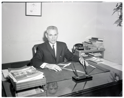
Film negative of Mayor Oran K. Gragson seated at his desk in City Hall, Las Vegas, Nevada, December 21, 1961
Date
1961-12-21
Archival Collection
Description
Portrait of Las Vegas Mayor Oran K. Gragson seated at his desk in City Hall. A certificate From Delta dated June 25, 1961 hangs on the wall behind him. Oran Kenneth Gragson (February 14, 1911 – October 7, 2002) was an American businessman and politician. He was the longest-serving mayor of Las Vegas, Nevada, from 1959 to 1975. Gragson, a member of the Republican Party, was a small business owner who was elected Mayor on a reform platform against police corruption and for equal opportunity for people of all socio-economic and racial categories. Gragson died in a Las Vegas hospice on October 7, 2002, at the age of 91. The Oran K. Gragson Elementary School located at 555 N. Honolulu Street, Las Vegas, NV 89110 was named in his honor.
Image
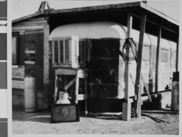
Photograph of a shack house in West Las Vegas, located between Van Buren Avenue and the North Project Boundary, and H and J Streets, Las Vegas, Nevada, October, 1957
Date
1957-10
Archival Collection
Description
A shack house located between Van Buren Avenue and the North Project Boundary, and H and J Streets, West Las Vegas, Nevada. There is a shell of an old school bus under a roof extension that has been fitted with an air conditioner. A sign leaning against a metal tank that is located under the air conditioner reads "8." The photograph was taken by Henry Elder, City Building Inspector, October, 1957. Refer to photo #0310 0058 (pho017999) for an aerial view of the area.
Image
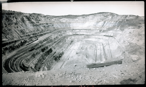
Film transparency of an open-pit copper mine, Ruth, Nevada, August, 1937
Date
1937-08
Archival Collection
Description
An open-pit copper mine located in Ruth, Nevada. Surface mining is done by removing (stripping) surface vegetation, dirt, and, if necessary, layers of bedrock in order to reach buried ore deposits. Techniques of surface mining include: open-pit mining, which is the recovery of materials from an open pit in the ground, quarrying, identical to open-pit mining except that it refers to sand, stone and clay; strip mining, which consists of stripping surface layers off to reveal ore/seams underneath; and mountaintop removal, commonly associated with coal mining, which involves taking the top of a mountain off to reach ore deposits at depth. Most (but not all) placer deposits, because of their shallowly buried nature, are mined by surface methods. Finally, landfill mining involves sites where landfills are excavated and processed.
Image

Film transparency of Cathedral Gorge, Panaca, Nevada, circa 1940s-1950s
Date
1940 to 1959
Archival Collection
Description
Cathedral Gorge near Panaca, Nevada. Cathedral Gorge State Park is a state park of Nevada, USA, featuring a gorge eroded through soft bentonite clay. The park covers 1,608 acres (651 ha). It is located in Central/Eastern Nevada along U.S. Route 93, 1 mile (1.6 km) north of the west end of State Route 319, near Panaca. Cathedral Gorge was established as one of the four original Nevada State Parks in 1935. The park sits at an elevation of 4,800 feet (1,500 m) above sea level, and is typically arid with semi-hot summers, and very cold winters. In the summer, temperatures usually range from 95 °F (35 °C) in midday to roughly 55 °F (13 °C) at night. Rainfall is variable, and thunderstorms are prevalent. At one time, Shakespearean plays were performed with the clay formations in the backdrop. The various naturally formed crevices were used as dressing rooms and as a backstage where actors and actresses would prepare, awaiting their cue.
Image
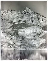
Film transparency of Angel Lake, Nevada, November 10, 1976
Date
1976-11-10
Archival Collection
Description
Angel Lake, Nevada. Angel Lake is a glacial tarn in the northern part of the East Humboldt Range, in central Elko County in the northeastern part of the state of Nevada. It is located at approximately 41°01.6?N 115°05.1?W, and at an elevation of 8378 feet (2553 m). It has an area of approximately 13 acres (5.2 hectares), and a depth of up to 29 feet (9 m). A 12-mile (19 km) scenic highway, State Route 231, climbs from Interstate 80's exit 351 in Wells to the eastern shore of the lake. Located at the base of a steep cirque, the lake is surrounded by high cliffs. Greys Peak (10,674 ft, 3253 m) rises high to the west, and to the south is a group of pinnacles known as Chimney Rock. Far below and to the east lies Clover Valley and the community of Wells.
Image
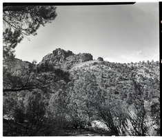
Film transparency of the Beaver Dam area near Carp, Nevada, November, 1954
Date
1954-11
Archival Collection
Description
Beaver Dam area east of Carp, Nevada. Carp, Nevada is an unincorporated community in Lincoln County, Nevada, United States located 35 miles (56 km) south of Caliente. It sits on the Meadow Valley Wash, which empties into Lake Mead. Carp was originally a small railroad station for the Union Pacific Railroad. The post office started under the name of "Carpsdale" on June 29, 1918, but was rescinded. It then officially opened under the name of "Cliffdale" June 7, 1921 and changed yet again to "Carp" December 1, 1925. The Carp post office remained open to serve rural ranches until July 1, 1974, when it closed permanently. Little remains of Carp today except a railroad siding usually occupied by idling trains, and the remains of the watering reservoir.
Image
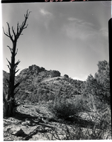
Film transparency of the Beaver Dam area near Carp, Nevada, November, 1954
Date
1954-11
Archival Collection
Description
Beaver Dam area east of Carp, Nevada. Carp, Nevada is an unincorporated community in Lincoln County, Nevada, United States located 35 miles (56 km) south of Caliente. It sits on the Meadow Valley Wash, which empties into Lake Mead. Carp was originally a small railroad station for the Union Pacific Railroad. The post office started under the name of "Carpsdale" on June 29, 1918, but was rescinded. It then officially opened under the name of "Cliffdale" June 7, 1921 and changed yet again to "Carp" December 1, 1925. The Carp post office remained open to serve rural ranches until July 1, 1974, when it closed permanently. Little remains of Carp today except a railroad siding usually occupied by idling trains, and the remains of the watering reservoir.
Image
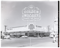
Film transparency of the Golden Nugget Gambling Hall, Las Vegas, Nevada, July, 1949
Date
1949-05
Archival Collection
Description
A view of the front of the Golden Nugget Gambling Hall. A banner advertising "Cooled by refrigeration always pleasant" is visible on the right-hand side of the building. The Nugget Saloon and a Shell gas station sign is visible in the background. The Golden Nugget opened in 1946, and is the first structure designed from the ground up to be a casino. Steve Wynn became the majority shareholder in 1973, and built the first tower in 1977. In 1984, the neon was removed from the building and the spa tower was built, along with the showroom. The third tower was opened in 1989. The hotel now has 2,419 rooms and suites. The casino's large hotel sign at its entrance off Fremont and Casino Center was removed in 1984 when the casino underwent renovations. The old sign presently sits at the YESCO (Young Electric Sign Company) sign yard.
Image
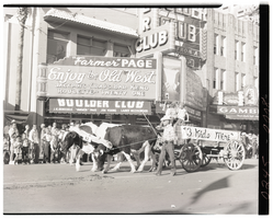
Film transparency of the buckboard dubbed "3 Kids Mine" in the Helldorado Parade on Fremont Street, Las Vegas, Nevada, May, 1958
Date
1958-05
Archival Collection
Description
Entry number 92 in the Helldorado Parade on Fremont Street, Las Vegas, Nevada, May, 1958 The buckboard is dubbed "3 Kids Mine," and is being pulled by two young oxen. Three young children are riding on the buckboard, while an unidentified man guides the livestock. They are in front of the Boulder Club, located at 118 Fremont Street. The Boulder Club was in operation from 1931-1960. A sign on the Boulder Club reads ""Farmer" Page - Enjoy the Old West - Jackpots, Craps, Bar, Keno, Roulette, Twenty-One." A smaller banner reads "J. K. Houssels - "Farmer" Page - Jim Young - Larry Hezzelwood."
Image
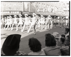
Film transparency of an all female drill team in the Helldorado Parade on Fremont Street, Las Vegas, Nevada, May, 1958
Date
1958-05
Archival Collection
Description
An all-female drill team marching in the Helldorado Parade on Fremont Street, May 1958. They are in front of the Boulder Club, located at 118 Fremont street. The Boulder Club was in operation from 1931-1960. A sign on the Boulder Club reads ""Farmer" Page - Enjoy the Old West - Jackpots, Craps, Bar, Keno, Roulette, Twenty-One." Joe W. Brown's Horseshoe Club (in operation from 1935-1958), located 128 Fremont Street at the corner of Fremont Street and 2nd Street is visible in the background.
Image
Pagination
Refine my results
Content Type
Creator or Contributor
Subject
Archival Collection
Digital Project
Resource Type
Year
Material Type
Place
Language
Records Classification
