Search Results
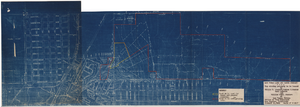
Map to accompany agreement with Willie T. Stewart covering lease of land at Las Vegas, Nevada, August 10, 1943
Date
1943-08-10
Archival Collection
Description
'Las Vegas Land and Water Company.' 'Office of Vice President, Los Angeles, California, August 10, 1943.' Relief shown by contours. Cadastral map. Scale [ca. 1:7,200]. 1 in.=600 feet..
Image
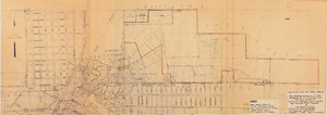
Map showing property to be leased to Willie T. Stewart, Vernon E. Bunker, Earl Leavitt and William Udell Stewart at Las Vegas, Nevada, January 31, 1951
Date
1951-01-31
Archival Collection
Description
'Office of Vice President, Los Angeles, California.' Accompanies: William Reinhardt letter to A. E. Stoddard, January 31, 1951 (Box 11 Folder W18-1-12).
Image
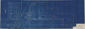
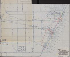
Map showing location of leased properties proposed to be sold to the Las Vegas Land and Water Company, October 2, 1952
Date
1952-10-02
Archival Collection
Description
'October 2, 1952.' Relief shown by contours. Hand-drawn lines mark land leased to these people, land proposed to be withdrawn from lease, and easement for a sewer. Scale [ca. 1:7,200]. 1 in.=600 feet. Blueline.
Image
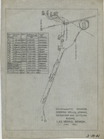
Diagrammatic drawing showing wells, springs, reservoir and settling basins, Las Vegas, Nevada, June 1942
Date
1942-06
Archival Collection
Description
Hand-drawn in pencil on tracing cloth. "June 1942." Also shows pipelines and power lines. Includes a hand-written table showing the number of the well or spring, casing size, depth, capacity in gallons per day, and whether it is pump or artesian. "3-18-41"--Written in black grease pencil in lower right corner of map.
Text
Map of water pipelines owned by or to be sold to the Las Vegas Valley Water District, March 1, 1953
Date
1953-03-01
Archival Collection
Description
Map shows portions of pipelines to be sold to the Las Vegas Valley Water District, pipelines connected to those to be sold to the District that will be retained by the railroad companies, and privately-owned pipelines connecting to those to be sold to the District. 'Exhibit D.' 'March 1, 1953.' 'I-128.' Las Vegas Land and Water Company?
Image
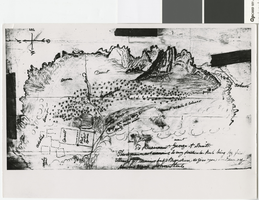
Hand-drawn map of the Mormon Fort and Las Vegas Valley from a letter by John Steele to Brigham Young, circa 1855
Date
1850 to 1859
Archival Collection
Description
Hand-drawn map showing area around the Mormon Fort in Las Vegas, Nevada, circa 1855. Handwritten in lower right: 'To President George A. Smith. This is drawn not according to any particular rule being my first attempt at drawing but it may serve to give you an idea of the Las Vegas. John Steele.' Copy print of material in LDS Archives. Scale not given..
Image

Blueprint map showing proposed changes to water system, Las Vegas Land & Water Co., Las Vegas, Nevada, circa 1936
Date
1931 to 1941
Archival Collection
Description
'U.P.C. Co. #1799.31-T3-L3.'
Image
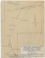
Map showing location of proposed 12-inch water main to connect Well #8 with settling basin serving Reservoir No. 2 at Las Vegas, Nevada, January 16, 1950
Date
1950-01-16
Archival Collection
Description
'Office of Manager-Industrial Development, Los Angeles, California.' Scale: 1" = 600'. 10 3/8 in. x 8 in.
Image
Map showing chemical diagrams representing quality of water in Clark and Nye counties, Nevada, 1963
Date
1963
Description
'T.E. Eakin, S.L. Schoff, and P. Cohen, 1963.' 'Department of the Interior, United States Geological Survey, TEI-833.' 'Prepared in cooperation with the U.S. Atomic Energy Commission.' Scale 1:500,000 (W 117°00´--W 115°00´/N 38°30´--N 36°30´). Originally published as figure 3 in Regional hydrology of a part of southern Nevada : a reconnaissance / by Thomas E. Eakin, Stuart L. Schoff, and Philip Cohen, published by the U.S. Geological Survey in 1963 as number 833 of the Trace elements investigation report.
Image

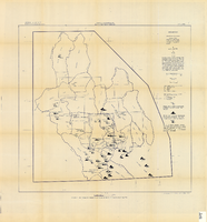
Map of Las Vegas, Nevada, annotated to show different soil types, September 2, 1948
Date
1948-09-02
Archival Collection
Description
'Types of soil as determined by James M. Montgomery for use in appraisal. (Copy). LRM 7/10/52'--handwritten in blue pencil in lower right corner of map. 'September 2, 1947. Revised September 2, 1948.' Soil was designated as badly corrosive, mildly corrosive, or non-corrosive by hand-drawn colored lines and hand-printed labels. Soil was surveyed to measure its effect on water pipes. Scale [ca. 1:7,200] 1 in.=600 feet.
Image