Search Results
The New Superstar Commune: Las Vegas, Cavalier, 1975 July 24
Level of Description
Item
Archival Collection
Arnold Shaw Papers
To request this item in person:
Collection Number: MS-00432
Collection Name: Arnold Shaw Papers
Box/Folder: Box 14
Collection Name: Arnold Shaw Papers
Box/Folder: Box 14
Archival Component

Map of California, and territories of Utah, Nevada, Colorado, New Mexico and Arizona, 1864
Date
1864
Description
'Johnson's California, also Utah, Nevada, Colorado, New Mexico, and Arizona, published by A.J. Johnson, New York.' 'Entered according to act of Congress in the year 1864, by A.J. Johnson in the Clerks Office of the District Court of the United States for the southern district of New York.' Atlas page numbers in upper margin: 67-68. Relief shown by hachures. Prime meridian: Greenwich and Washington. Shows natural features, locations of Indian tribes, proposed railroad routes, routes of explorers, trails, county boundaries and populated places. Hand colored. On verso: 'Historical and statistical view of the West India Islands or Columbian Archipelago' (p. 80) and 'Historical and statistical view of Mexico and Central America' (p. 79). Scale [ca. 1:3,484,800]. 1 in. to ca. 55 miles (W 124°--W 102°/N 42°--N 32°).
Text
Carson, Steve, Stewart Title, 1975 July 15
Level of Description
File
Archival Collection
Frank Mitrani Photographs
To request this item in person:
Collection Number: PH-00332
Collection Name: Frank Mitrani Photographs
Box/Folder: Box 42
Collection Name: Frank Mitrani Photographs
Box/Folder: Box 42
Archival Component
Howard Hughes is appointed Aeronautic Adviser to the 1939 New York World's Fair by Grover Whalen, 1938
Level of Description
File
Archival Collection
Howard Hughes Public Relations Photograph Collection
To request this item in person:
Collection Number: PH-00373
Collection Name: Howard Hughes Public Relations Photograph Collection
Box/Folder: Folder 10
Collection Name: Howard Hughes Public Relations Photograph Collection
Box/Folder: Folder 10
Archival Component
Emriquez, Mary, Ronzones Apparel, 1968 July 15
Level of Description
File
Archival Collection
Frank Mitrani Photographs
To request this item in person:
Collection Number: PH-00332
Collection Name: Frank Mitrani Photographs
Box/Folder: Box 17
Collection Name: Frank Mitrani Photographs
Box/Folder: Box 17
Archival Component
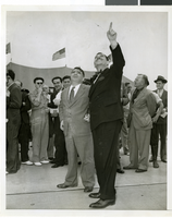
Photograph a crowd awaiting watching Howard Hughes land, New York, July 14, 2013
Date
1938-07-14
Archival Collection
Description
The black and white view Mayor Laguardia and Grover Whelen watched Howard Hughes land in his Lockheed 14 aircraft at Floyd Bennett Field, New York. Typed onto a piece of paper attached to the image: "Mayor Laguardia (left) and Grover Whelen looking skyward as they see the approaching Howard Hughes and his globe girdlers complete A Round The World flight, 7-24-38. (Press Association)."
Image
George Francis Robert Bell, age one month on the baby scales, probably 1938 July
Level of Description
File
Archival Collection
Walking Box Ranch Photograph Collection
To request this item in person:
Collection Number: PH-00346
Collection Name: Walking Box Ranch Photograph Collection
Box/Folder: N/A
Collection Name: Walking Box Ranch Photograph Collection
Box/Folder: N/A
Archival Component
#65212: New Student Union Building, Exteriors, 2006 July 05
Level of Description
File
Archival Collection
University of Nevada, Las Vegas Creative Services Records (2000s)
To request this item in person:
Collection Number: PH-00388-04
Collection Name: University of Nevada, Las Vegas Creative Services Records (2000s)
Box/Folder: N/A
Collection Name: University of Nevada, Las Vegas Creative Services Records (2000s)
Box/Folder: N/A
Archival Component
#64785: New Student Union - Start of Construction, 2005 July 08
Level of Description
File
Archival Collection
University of Nevada, Las Vegas Creative Services Records (2000s)
To request this item in person:
Collection Number: PH-00388-04
Collection Name: University of Nevada, Las Vegas Creative Services Records (2000s)
Box/Folder: N/A
Collection Name: University of Nevada, Las Vegas Creative Services Records (2000s)
Box/Folder: N/A
Archival Component
#65755: New Student Recreation Center - Exteriors, 2007 July 11
Level of Description
File
Archival Collection
University of Nevada, Las Vegas Creative Services Records (2000s)
To request this item in person:
Collection Number: PH-00388-04
Collection Name: University of Nevada, Las Vegas Creative Services Records (2000s)
Box/Folder: N/A
Collection Name: University of Nevada, Las Vegas Creative Services Records (2000s)
Box/Folder: N/A
Archival Component