Search Results

Photograph of Howard Hughes' plane at Floyd Bennet Airfield, New York, August 20, 1938
Date
1938-08-20
Archival Collection
Description
Description given with photograph: "Hughes sets new transcontinental transport mark. Floyd Bennet Field, NY--- Howard Hughes, millionaire flier, setting his famous round-the-world transport plane down here, early August 20th, after a record-smashing flight from Los Angeles. Hughes and three companions completed the trip in 10 hours 32 minutes and 20 seconds, shattering the record of 11 hours and five minutes set four years ago by Tommy Tomlinson. The flight was made most of the way in the substratosphere at an average altitude of 17, 000 feet. Credit Line ACME."
Image

Map of California, Utah, Nevada, Colorado, New Mexico and Arizona, 1864
Date
1864
Description
'Johnson's California, with Utah, Nevada, Colorado, New Mexico, and Arizona, published by Johnson and Ward.' 'Entered according to Act of Congress in the Year 1864 by A.J. Johnson in the Clerks Office of the District Court of the United States for the southern district of New York.' Atlas page numbers in upper margin: 66-67. This is probably plate 67 from Johnson's New Illustrated Family Atlas, published in New York by Johnson & Ward in 1864. Shows natural features, locations of Indian tribes, proposed railroad routes, routes of explorers, trails, county boundaries and populated places ; "." ; Relief shown by hachures ; Prime meridians: Greenwich and Washington ; In top margin: 66-67 ; Hand colored ; On verso: Historical and statistical view of Mexico and central America (p. 79) and Historical and statistical view of the United States, 1860 (p. 78) Scale [ca. 1:3,484,800]. 1 in. to ca. 55 miles (W 124°--W 102°/N 42°--N 32°)
Text
Howard Hughes in his Lockheed 14 aircraft, Floyd Bennett Field, New York, 1938
Level of Description
File
Archival Collection
Howard Hughes Public Relations Photograph Collection
To request this item in person:
Collection Number: PH-00373
Collection Name: Howard Hughes Public Relations Photograph Collection
Box/Folder: Folder 06
Collection Name: Howard Hughes Public Relations Photograph Collection
Box/Folder: Folder 06
Archival Component
#69247: New faculty members on August 15, 2013, 2013 August 15
Level of Description
File
Archival Collection
University of Nevada, Las Vegas Creative Services Records (2010s)
To request this item in person:
Collection Number: PH-00388-05
Collection Name: University of Nevada, Las Vegas Creative Services Records (2010s)
Box/Folder: Digital File 00
Collection Name: University of Nevada, Las Vegas Creative Services Records (2010s)
Box/Folder: Digital File 00
Archival Component
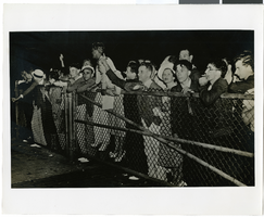
Photograph of a crowd greeting Howard Hughes at Floyd Bennett Field Airport, July 14, 1938
Date
1938-07-14
Archival Collection
Description
The black and white view of a crowd of people gathering to greet Howard Hughes at Floyd Bennett Field Airport in New York. Typed onto a piece of paper attached to the image: "17. Rail birds, part of crowd that waited all nite. International news. (Evening Herald)."
Image

Map of the territories of New Mexico, Arizona, Colorado, Nevada, and Utah, 1855
Date
1855
Description
29 x 36 cm. Relief shown by hachures. Prime meridians: Greenwich and Washington. "Entered according to act of Congress in the year 1855 by J.H. Colton & Co. in the Clerk's Office of the Dist. Office of the U.S. for the Southern. Dist. of New York." Hand colored. Decorative border. Atlas p. number in lower-right margin: 67. Shows routes of explorers, proposed railroad routes, wagon route, mail route, Indian reserves and mines. On verso: History and statistical view of Mexico. Original publisher: J.H. Colton.
Image
The New Fay Easter dinner menu, Sunday, April 7, 1912
Date
1912-04-07
Archival Collection
Description
Restaurant: The New Fay (Virginia, Minn.) Location: Virginia, Minnesota, United States
Text
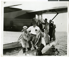
Photograph of Howard Hughes at a U.S. Coast Guard Station, January 15, 1938
Date
1938-01-15
Archival Collection
Description
Description printed on photograph's accompanying strip of paper: Howard Hughes being carried ashore after arrival in amphibian airplane at U.S. Coast Guard Station, Jamaica Bay, B.W.I.
Image
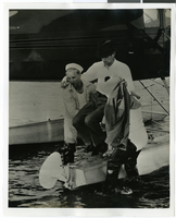

Map of California, Utah, Nevada, Colorado, New Mexico and Arizona, 1864
Date
1864
Description
'Johnson's California, also Utah, Nevada, Colorado, New Mexico, and Arizona, published by A.J. Johnson, New York.' 'Entered according to Act of Congress in the Year 1864, by A.J. Johnson in the Clerks Office of the District Court of the United States for the Southern District of New York.' Atlas page numbers in upper margin: 66-67. Relief shown by hachures. Prime meridians: Greenwich and Washington, D.C. Shows proposed railroads, locations of Indian tribes, natural features, counties, mines, mail routes, trails and routes of exploring expeditions. On verso: History and statistics of Mexico and Central America and statistics of national finances and the Post Office of the United States, 1860. Scale [ca. 1:3,484,800. 1 in. to ca. 55 miles] (W 123°--W 103°/N 42°--N 32°)
Text