Search Results
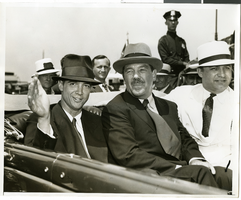
Photograph of Howard Hughes and crew at a parade, New York, July 15, 1938
Date
1938-07-15
Archival Collection
Description
The black and white view of Howard Hughes and his crew at a parade for Howard Hughes after he completed his Around The World flight in New York.
Image
Photograph of Howard Hughes and crew at a parade, New York, July 15, 1938
Date
1938-07-15
Archival Collection
Description
The black and white view of Howard Hughes and his crew at a parade for Howard Hughes after he completed his Around The World flight in New York.
Image

Map of California, Nevada, Utah, Colorado, Arizona & New Mexico, circa 1867
Date
1865 to 1869
Description
39 x 62 cm. Relief shown by hachures and spot heights. Prime meridian: Greenwich and Washington. Hand colored. Shows natural features, populated places, routes of mail steamships, routes of explorers, locations of Indian tribes, railroad routes, and proposed railroad routes. In top margin: No. 80-81. On verso: New Mexico, Arizona, Colorado, Idaho, Dakota (statistics and other information) and The state of California (statistics and other information). Original publisher: G.W. and C.B. Colton.
Image

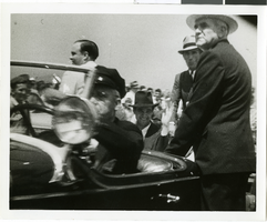
Photograph of Howard Hughes in City Hall, New York City, July 15, 1938
Date
1938-07-15
Archival Collection
Description
Typed onto a piece of paper attached to the image: "New York Hails Hughes and His Companions, New York City - In the greatest reception since Lindbergh's, Howard Hughes and his four gallant companions paraded up Broadway July 15 almost smothered beneath New York's ticker tape accolade recognizing their record-smashing Round-The-World dash. This picture shows Hughes at City Hall as he paused only long enough for a glass of water. At right is his fellow Texan, Jesse Johes, chairman of the Reconstruction Finance Corporation. Credit Line (ACME) 7-15-38."
Image
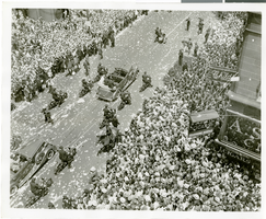
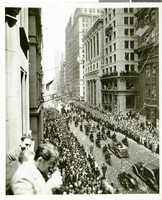
Photograph of a parade for Howard Hughes, New York City, July 15, 1938
Date
1938-07-15
Archival Collection
Description
The view of a crowd consisting of thousands of people who attended a parade that celebrated Howard Hughes completion of his flight Around the World in New York City.
Image
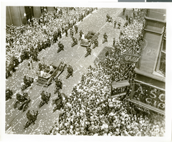
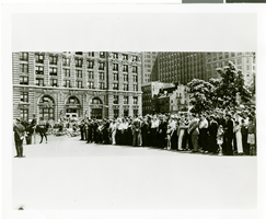
Photograph of a parade for Howard Hughes, New York City, July 15, 1938
Date
1938-07-15
Archival Collection
Description
The view of a crowd consisting of thousands of people who attended a parade that celebrated Howard Hughes completion of his flight Around the World in New York City.
Image
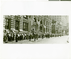
Photograph of a parade for Howard Hughes, New York City, July 15, 1938
Date
1938-07-15
Archival Collection
Description
The view of a crowd consisting of thousands of people who attended a parade that celebrated Howard Hughes completion of his flight Around the World in New York City.
Image
Photograph of a parade for Howard Hughes, New York City, July 15, 1938
Date
1938-07-15
Archival Collection
Description
The view of a crowd consisting of thousands of people who attended a parade that celebrated Howard Hughes completion of his flight Around the World in New York City.
Image
Photograph of a parade for Howard Hughes, New York City, July 15, 1938
Date
1938-07-15
Archival Collection
Description
The view of a crowd consisting of thousands of people who attended a parade that celebrated Howard Hughes completion of his flight Around the World in New York City.
Image

Map of California, and territories of Utah, Nevada, Colorado, New Mexico and Arizona, 1864
Date
1864
Description
'Johnson's California, also Utah, Nevada, Colorado, New Mexico, and Arizona, published by A.J. Johnson, New York.' 'Entered according to act of Congress in the year 1864, by A.J. Johnson in the Clerks Office of the District Court of the United States for the southern district of New York.' Atlas page numbers in upper margin: 67-68. Relief shown by hachures. Prime meridian: Greenwich and Washington. Shows natural features, locations of Indian tribes, proposed railroad routes, routes of explorers, trails, county boundaries and populated places. Hand colored. On verso: 'Historical and statistical view of the West India Islands or Columbian Archipelago' (p. 80) and 'Historical and statistical view of Mexico and Central America' (p. 79). Scale [ca. 1:3,484,800]. 1 in. to ca. 55 miles (W 124°--W 102°/N 42°--N 32°).
Text