Search Results
Photograph of Howard Hughes in New York, July 14, 1938
Date
1938-07-14
Archival Collection
Description
Typed onto a piece of paper attached to the image: "Scene at Floyd Bennett Field as Howard Hughes and his crew landed after completing a round the world hop. 7-14-38. (Press Association)."
Image
Photograph of Howard Hughes and his crew at a parade, New York, July 15, 1938
Date
1938-07-15
Archival Collection
Description
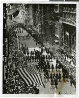
The view of Howard Hughes and his crew at a parade after he completed his Round-The-World flight in New York.
Image

Map of California, Utah, Nevada, Colorado, New Mexico and Arizona, 1864
Date
1864
Description
'Johnson's California, also Utah, Nevada, Colorado, New Mexico, and Arizona, published by A.J. Johnson, New York.' 'Entered according to Act of Congress in the Year 1864, by A.J. Johnson in the Clerks Office of the District Court of the United States for the Southern District of New York.' Atlas page numbers in upper margin: 66-67. Relief shown by hachures. Prime meridians: Greenwich and Washington, D.C. Shows proposed railroads, locations of Indian tribes, natural features, counties, mines, mail routes, trails and routes of exploring expeditions. On verso: History and statistics of Mexico and Central America and statistics of national finances and the Post Office of the United States, 1860. Scale [ca. 1:3,484,800. 1 in. to ca. 55 miles] (W 123°--W 103°/N 42°--N 32°)
Text
Photograph of crowds at Floyd Bennett Airfield, New York, July 1938
Date
1938-07-14
Archival Collection
Description
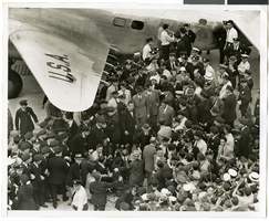
The black and white view of Howard Hughes exiting his Lockheed 14 aircraft after performing the final landing on the Round the World flight at Floyd Bennett Airport, New York. Description printed on photograph's accompanying sheet of paper: "Telling the world about the record-smashing flight. New York City--Under the giant wing of the huge Lockheed plane, radio men set up their microphones so that Howard Hughes and his gallant crew of four can send a few words of greeting to the world over the air waves after landing at Floyd Bennett Field on their record-smashing flight around the world. Credit Line (ACME) 7/14/38"
Image

Photograph of crowds at Floyd Bennett Airfield, New York, July 1938
Date
1938-07-14
Archival Collection
Description
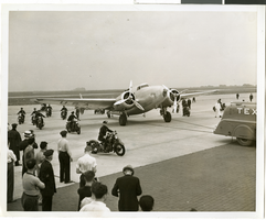
The black and white view of Howard Hughes' Lockheed 14 aircraft after performing its final landing on the Round the World flight at Floyd Bennett Airport, New York. Description printed on photograph's accompanying sheet of paper: "Howard Hughes reception at Floyd Bennett Field 7/14/38."
Image

Photograph of a parade procession, New York, July 15, 1938
Date
1938-07-15
Archival Collection
Description
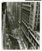
An overhead view of people looking up and waving during a parade procession.
Image

Photograph of a parade procession, New York, July 15, 1938
Date
1938-07-15
Archival Collection
Description
An overhead view of a parade procession celebrating Howard Hughes' completion of his round-the-world flight.
Image

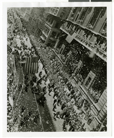
Photograph of a parade procession, New York, July 15, 1938
Date
1938-07-15
Archival Collection
Description
An overhead view of a parade procession celebrating Howard Hughes' completion of his round-the-world flight.
Image
Photograph of a parade procession, New York, July 15, 1938
Date
1938-07-15
Archival Collection
Description
An overhead view of a parade procession celebrating Howard Hughes' completion of his round-the-world flight.
Image
Photograph of a parade procession, New York, July 15, 1938
Date
1938-07-15
Archival Collection
Description
An overhead view of a parade procession celebrating Howard Hughes' completion of his round-the-world flight.
Image