Search Results
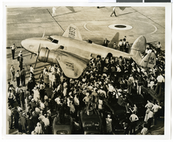
Photograph of the Lockheed 14 aircraft at Floyd Bennett Field, New York, July 10, 1938
Date
1938-07-10
Archival Collection
Description
The black and white view of the Lockheed 14 aircraft being surrounded by people at Floyd Bennett Field in New York.
Image
View of Waldorf Astoria, St. Bartholomew's Church, and Pan Am building from Park Avenue, New York City, New York: panoramic photograph, 1981 May 24
Level of Description
Item
Archival Collection
Bob Paluzzi Panoramic Photographs
To request this item in person:
Collection Number: PH-00414
Collection Name: Bob Paluzzi Panoramic Photographs
Box/Folder: Box 07, Digital File 00
Collection Name: Bob Paluzzi Panoramic Photographs
Box/Folder: Box 07, Digital File 00
Archival Component
George Treem and Charlie Dorenwend, 1954 July 15
Level of Description
File
Archival Collection
Henderson Public Library Photograph Collection on Henderson, Nevada
To request this item in person:
Collection Number: PH-00254
Collection Name: Henderson Public Library Photograph Collection on Henderson, Nevada
Box/Folder: Folder 01
Collection Name: Henderson Public Library Photograph Collection on Henderson, Nevada
Box/Folder: Folder 01
Archival Component

Map of California, territories of New Mexico, Arizona, Colorado, Nevada and Utah, circa 1863
Date
1861 to 1865
Description
40 x 62 cm. Relief shown by hachures and spot heights. Prime meridians: Greenwich and Washington. "Historical and statistical view of the United States, 1860"--Verso. Atlas page numbers at top: 58-59. Arizona became a territory in 1863, and Nevada became a state on October 31, 1864, so this map was either published in 1863 or in 1864 before the end of October. Original publisher: Johnson and Ward.
Image
Taylour Tedder (Boulder City, City Manager) oral history interview conducted by Kelliann Beavers, 2022 July 20
Level of Description
Item
Archival Collection
Lincy Institute "Perspectives from the COVID-19 Pandemic" Oral History Project
To request this item in person:
Collection Number: MS-01178
Collection Name: Lincy Institute "Perspectives from the COVID-19 Pandemic" Oral History Project
Box/Folder: Digital File 00
Collection Name: Lincy Institute "Perspectives from the COVID-19 Pandemic" Oral History Project
Box/Folder: Digital File 00
Archival Component
Carson, Steve, Stewart Title, 1975 July 15
Level of Description
File
Archival Collection
Frank Mitrani Photographs
To request this item in person:
Collection Number: PH-00332
Collection Name: Frank Mitrani Photographs
Box/Folder: Box 42
Collection Name: Frank Mitrani Photographs
Box/Folder: Box 42
Archival Component
Emriquez, Mary, Ronzones Apparel, 1968 July 15
Level of Description
File
Archival Collection
Frank Mitrani Photographs
To request this item in person:
Collection Number: PH-00332
Collection Name: Frank Mitrani Photographs
Box/Folder: Box 17
Collection Name: Frank Mitrani Photographs
Box/Folder: Box 17
Archival Component
Boulder City Parkway planting plan, 2000 July
Level of Description
File
Archival Collection
UNLV University Libraries Collection of Architecture Drawings
To request this item in person:
Collection Number: MS-00923
Collection Name: UNLV University Libraries Collection of Architecture Drawings
Box/Folder: Roll 093, Roll 095
Collection Name: UNLV University Libraries Collection of Architecture Drawings
Box/Folder: Roll 093, Roll 095
Archival Component

City of Las Vegas map, 1952
Date
1952
Description
General information on Las Vegas and index on verso ; Copyright held by Redwood Publishing Co. ; Includes inset map of the Strip (U.S. 91 or Los Angeles Highway) ; Redwood Publishing Company
Text
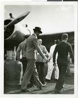
Photograph of Howard Hughes and the Lockheed 14 aircraft, Fairbanks, Alaska, July 15, 1938
Date
1938-07-15
Archival Collection
Description
The black and white view of Howard Hughes walking with other unidentified men toward the Lockheed 14 aircraft that was then being refueled. Hughes was then on his Around the World Flight where he visited Paris, Moscow, Fairbanks, and Alaska.
Image