Search Results
"The Likely Impact of New York City Casinos on the New York Racing Association", 1979
Level of Description
File
Archival Collection
Eugene Martin Christiansen Papers
Archival Component
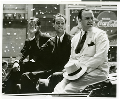
Photograph of a parade procession for Howard Hughes, New York, July 15, 1938
Date
1938-07-15
Archival Collection
Description
Typed onto a piece of paper attached to the image: new York Hails Hughes and Companions, New York City --- In the greatest reception since Lindbergh's, Howard Hughes and his four gallant companions paraded up Broadway July 15 almost smothered beneath Manhattan's ticker tape accolade recognizing their record-smashing Round-the-World flight. This picture shows Hughes, center, waving to the cheering thousands. On the left is Grover Whalen, commissioner of the New York 1939 World's Fair and on the right is Al Lodwick, Hughes' flight manager. 7-15-38. Credit Line (ACME)."
Image
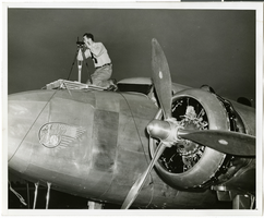
Photograph of Hiram "Tommy" Thurlow and the Lockheed 14, New York, July 9, 1938
Date
1938-07-09
Archival Collection
Description
The black and white view of Hiram "Tommy" Thurlow and the Lockheed 14 aircraft in New York, New York. Typed on a piece of paper attached to the image: "Readying Hughes' plane for Paris flight. New York City-- Mechanics hastened to put Howard Hughes' Lockheed 14 monoplane in shape for a flight from Floyd Bennett Airport here, to Paris. Motor trouble forced postponement and helpers were working under injunction to have the ship ready for a takeoff "at the earliest possible moment," July 9. Photo shows: Lieut, Thomas A. Thurlow, navigator, calibrating compass on plane. Credit Line (ACME) 7/9/1938."
Image

Map of California, Utah, Nevada, Colorado, New Mexico and Arizona, 1864
Date
1864
Description
'Johnson's California, with Utah, Nevada, Colorado, New Mexico, and Arizona, published by Johnson and Ward.' 'Entered according to Act of Congress in the Year 1864 by A.J. Johnson in the Clerks Office of the District Court of the United States for the southern district of New York.' Atlas page numbers in upper margin: 66-67. This is probably plate 67 from Johnson's New Illustrated Family Atlas, published in New York by Johnson & Ward in 1864. Shows natural features, locations of Indian tribes, proposed railroad routes, routes of explorers, trails, county boundaries and populated places ; "." ; Relief shown by hachures ; Prime meridians: Greenwich and Washington ; In top margin: 66-67 ; Hand colored ; On verso: Historical and statistical view of Mexico and central America (p. 79) and Historical and statistical view of the United States, 1860 (p. 78) Scale [ca. 1:3,484,800]. 1 in. to ca. 55 miles (W 124°--W 102°/N 42°--N 32°)
Text

Photograph of crowds at Floyd Bennett Airfield, New York, July 1938
Date
1938-07-14
Archival Collection
Description
The black and white view of Howard Hughes exiting his Lockheed 14 aircraft after performing the final landing on the Round the World flight at Floyd Bennett Airport, New York. Description printed on photograph's accompanying sheet of paper: "Telling the world about the record-smashing flight. New York City--Under the giant wing of the huge Lockheed plane, radio men set up their microphones so that Howard Hughes and his gallant crew of four can send a few words of greeting to the world over the air waves after landing at Floyd Bennett Field on their record-smashing flight around the world. Credit Line (ACME) 7/14/38"
Image

Map of the territories of New Mexico, Arizona, Colorado, Nevada, and Utah, 1855
Date
1855
Description
29 x 36 cm. Relief shown by hachures. Prime meridians: Greenwich and Washington. "Entered according to act of Congress in the year 1855 by J.H. Colton & Co. in the Clerk's Office of the Dist. Office of the U.S. for the Southern. Dist. of New York." Hand colored. Decorative border. Atlas p. number in lower-right margin: 67. Shows routes of explorers, proposed railroad routes, wagon route, mail route, Indian reserves and mines. On verso: History and statistical view of Mexico. Original publisher: J.H. Colton.
Image
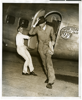
Photograph of Howard Hughes at Floyd Bennett Field, New York, July 9, 1938
Date
1938-07-09
Archival Collection
Description
The black and white view of Howard Hughes exiting an aircraft at Floyd Bennett Field in New York.
Image

City map of Las Vegas, 1973
Date
1905-05-26
Description
Color; 55 x 45 cm., on sheet 95 x 47 cm., folded to 24 x 10 cm. Panel title: Las Vegas city map. Copyright held by Cardinal Publishing Company. Relief shown by hachures. Includes illustrations and advertisements. Index, text, illustrations, advertisements, and map of "Lake Mead National Recreation Area, lower basin section" on verso. Original publisher: Cardinal Publishing Company.
Image
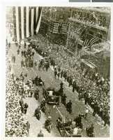
Photograph of a parade procession for Howard Hughes, New York, July 15, 1938
Date
1938-07-15
Archival Collection
Description
An aerial view of a crowd consisting of thousands of people who attended a parade that celebrated Howard Hughes completion of his flight round-the-world flight in New York City.
Image
Report: "Marketing Casino Gambling and a Local Lottery in New York City" by the Council of the City of New York for the Committee on Economic Development, 1991
Level of Description
File
Archival Collection
Eugene Martin Christiansen Papers
Archival Component