Search Results
Exterior view of Showboat Casino in the evening, Atlantic City, New Jersey, 1986
Level of Description
Archival Collection
Collection Name: Showboat Atlantic City Photograph Collection
Box/Folder: Folder 01
Archival Component
Exterior view of Showboat Casino in the evening, Atlantic City, New Jersey, 1986
Level of Description
Archival Collection
Collection Name: Showboat Atlantic City Photograph Collection
Box/Folder: Folder 01
Archival Component
Construction of the Showboat Casino high-rise, Atlantic City, New Jersey, 1986
Level of Description
Archival Collection
Collection Name: Showboat Atlantic City Photograph Collection
Box/Folder: Folder 01
Archival Component
Conceptual sketch of the interior of the Showboat Casino, Atlantic City, New Jersey, 1986
Level of Description
Archival Collection
Collection Name: Showboat Atlantic City Photograph Collection
Box/Folder: Folder 02
Archival Component
Conceptual sketch of the interior of Showboat Casino, Atlantic City, New Jersey, 1986
Level of Description
Archival Collection
Collection Name: Showboat Atlantic City Photograph Collection
Box/Folder: Folder 02
Archival Component
Conceptual sketch of the exterior of Showboat Casino, Atlantic City, New Jersey, 1986
Level of Description
Archival Collection
Collection Name: Showboat Atlantic City Photograph Collection
Box/Folder: Folder 02
Archival Component
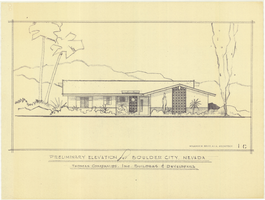
Architectural drawing of residential home in Boulder City, Nevada, preliminary elevation, 1962
Date
Archival Collection
Description
Preliminary drawing of front exterior elevation of ranch-style residential home in Boulder City, Nevada.
Architecture Period: Mid-Century ModernistImage
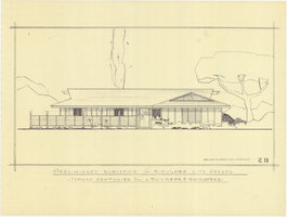
Architectural drawing of residential home in Boulder City, Nevada, preliminary elevation, 1962
Date
Archival Collection
Description
Preliminary drawing of front exterior elevation of a ranch-style residential home in Boulder City, Nevada.
Architecture Period: Mid-Century ModernistImage
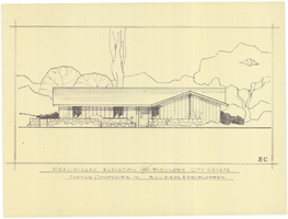
Architectural drawing of residential home in Boulder City, Nevada, preliminary elevation, 1962
Date
Archival Collection
Description
Preliminary drawing of front exterior elevation of a ranch-style residential home in Boulder City, Nevada.
Architecture Period: Mid-Century ModernistImage
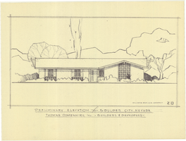
Architectural drawing of residential home in Boulder City, Nevada, preliminary elevation, 1962
Date
Archival Collection
Description
Preliminary drawing of front exterior elevation of a ranch-style residential home in Boulder City, Nevada.
Architecture Period: Mid-Century ModernistImage