Search Results
Construction of the Showboat high-rise, Atlantic City, New Jersey, 1986
Level of Description
Item
Archival Collection
Showboat Atlantic City Photograph Collection
Archival Component
Exterior view of Showboat Casino, Atlantic City, New Jersey, 1986
Level of Description
Item
Archival Collection
Showboat Atlantic City Photograph Collection
Archival Component

Map of California, territories of New Mexico, Arizona, Colorado, Nevada and Utah, circa 1863
Date
1861 to 1865
Description
40 x 62 cm. Relief shown by hachures and spot heights. Prime meridians: Greenwich and Washington. "Historical and statistical view of the United States, 1860"--Verso. Atlas page numbers at top: 58-59. Arizona became a territory in 1863, and Nevada became a state on October 31, 1864, so this map was either published in 1863 or in 1864 before the end of October. Original publisher: Johnson and Ward.
Image
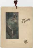
New Year's Eve 1913, dinner menu, Brigham's Hotel and Cafe
Date
1912-12-31 to 1913-01-01
Archival Collection
Description
Note: Two menus are shown inside, one is the "Table d'Hote" and the other is à la carte; both are served from 8:30 P.M. to 11:00 P.M. The prix fixe for the table d'hote is $2.50, with cocktails and cordials extra. Cover is embossed with holly leaves and features the hotel logo and an illustration of a ballerina. Cover illustration has an illegible artist's signature. Menu is tied with a dark red tassel Restaurant: Brigham's Hotel and Café Location: Boston, Massachusetts, United States
Text

Photograph of Howard Hughes and crew posing for photographs outside of City Hall, New York City, July 15, 1938
Date
1938-07-15
Archival Collection
Description
Typed onto a piece of paper attached to the image: "Howard Hughes reception at City Hall - 7/15/38. (Press Association)."
Image
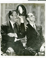
Photograph of Howard Hughes and Grover Whalen, New York City, July 15, 1938
Date
1938-07-15
Archival Collection
Description
The black and white view of Grover Whalen (left) and Howard Hughes (right) enjoying the attention from a crowd of thousands of people who attended a parade that celebrated Hughes' completion of his Round the World flight in New York City.
Image
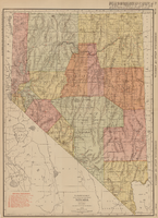
Rand-McNally new commercial atlas map of Nevada, 1912
Date
1912
Description
Original publisher: Rand, McNally & Co. Scale [ca. 1:1,203,840). 1 inch to 19 miles. Originally published as p. 316-317 of Rand McNally's commercial atlas of America. Title in right margin: Nevada : commercial atlas of America. Includes township and range grid. Includes index to Nevada railroads and index to principal cities with their populations. Index on verso to counties, towns and natural features in Oregon and Nevada.
Image
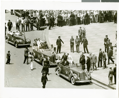
Photograph of a parade for Howard Hughes, New York City, July 15, 1938
Date
1938-07-15
Archival Collection
Description
Typed onto a piece of paper attached to the image: "Howard Hughes and his crew arriving at the City Hall after their Round-The-World flight. July 1938."
Image

Map of city of Las Vegas, Nevada, October 1, 1940
Date
1940-10-01
Description
'Compiled by C.D. Baker, Oct. 1, 1940.' Scale [ca. 1:11,400]. 1 in. to 950 ft. Cadastral map.
Image
Photographs of Harrah's property: Sky City (Auckland, New Zealand), undated
Level of Description
File
Archival Collection
Harrah’s Entertainment Corporate Archives
Archival Component